
Mouro Island facts for kids
|
Native name:
Isla de Mouro
|
|
|---|---|

Mouro Island in 2014
|
|

Mouro Island
Location in Cantabria
|
|
| Geography | |
| Location | Bay of Santander |
| Coordinates | 43°28′24″N 3°45′21″W / 43.473421°N 3.755768°W |
| Area | 2 ha (4.9 acres) |
| Highest elevation | 27.5 m (90.2 ft) |
| Administration | |
| City | Santander, Spain |
| Autonomous community | |
| Comarca | Bay of Santander |
| Demographics | |
| Population | 0 |
Mouro Island (Spanish: Isla de Mouro) is a small, empty island in the Bay of Biscay. It sits just off the coast of Santander in northern Spain. The island is tiny, only about 2 hectares (which is like 5 acres) in size. It's located near the entrance to the Bay of Santander.
Island's Name and Past

The island's first name was Mogro Island. This name was used in old papers from the 1500s. But in the 1700s, a mapmaker made a mistake. He wrote "Mouro" instead of "Mogro," and the new name stuck!
In July 1812, during a war called the Peninsular War, British forces took control of the island from Napoleon's army. This helped Spanish ships land safely nearby.
The only building on Mouro Island is an old lighthouse. It was built in the 1800s and now works all by itself. For many years, two lighthouse keepers lived there. They often got stuck on the island during big storms. In 1865, one keeper was swept away by a storm and sadly drowned. In 1895, another keeper passed away suddenly, but his body could not be moved for a while because of a storm. Another sad event happened when a lighthouse keeper's son slipped and died while trying to get onto the island.
In February 2014, a stunning photo of a huge wave crashing over the lighthouse became famous. It was even on the front page of newspapers around the world!
Amazing Plants and Animals

The waters around Mouro Island are full of life! You can find more than 39 different kinds of fish there. Because of all this amazing nature, the area around the island was made a marine reserve in 1986. This means it's a special protected zone for sea creatures.
On the island itself, you can find plants like heath, gorse, broom, and the eagle fern. There's also a plant called Carpobrotus edulis, which people think a lighthouse keeper might have brought to the island.
Mouro Island is also a very important home for seabirds. Many European storm petrels and herring gulls live there. In 2014, the Spanish government made Mouro Island a Special Protection Area (SPA). This helps make sure the birds living there are safe. It's against the rules to bring cats, rats, or other mammals to the island. A smaller island nearby, called Islote la Corbera, is also part of this protected area.
Celebrating Our Oceans
Every June, people celebrate World Oceans Day with a special event around Mouro Island. There's a swim and scuba diving event. There's also an island "hugging" event, where surfers and kayakers paddle all the way around the island. These events help everyone remember how important it is to protect our seas and oceans.
Gallery
-
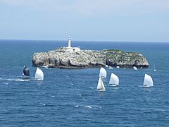
Yacht race in 2009
-
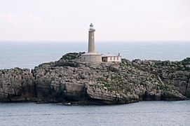
Island with lighthouse and lodgings, as seen in 2013
-
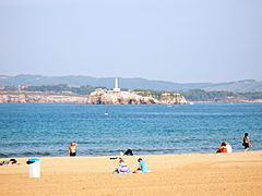
View of the island as seen from Sardinero
-
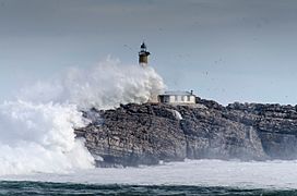
Waves crash over the lighthouse

_04.JPG)
.JPG)

See also
 In Spanish: Isla de Mouro para niños
- List of islands of Spain
