
Mull Hill facts for kids
Quick facts for kids Mull Hill |
|
|---|---|
| Cronk Meayll | |

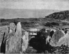
Mull Circle on top of Mull Hill, looking north towards Port Erin
|
|
| Highest point | |
| Elevation | 169 m (554 ft) |
| Prominence | c. 154 m |
| Listing | Marilyn |
| Geography | |
| Location | Rushen, Isle of Man |
| OS grid | SC189676 |
| Topo map | OS Landranger 95 IOM Outdoor Leisure Map (S) |
Mull Hill is a small hill found at the southern tip of the Isle of Man. Its name in the Manx language is Cronk Meayll. You can find it just outside the village of Cregneash, in Rushen Parish.
This hill is famous for two main things. First, it has an ancient stone circle called Mull Circle, also known as Meayll Circle. Second, it holds the remains of a World War II radar station.
The Ancient Mull Circle
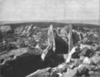
The Mull Circle is a very special and unique ancient monument. It was built a long, long time ago, around 3500 BC. That's about 5,500 years ago!
This stone circle is made up of twelve burial chambers. These chambers are arranged in a ring shape. There are six entrance passages, and each one leads into a pair of these chambers.
Archaeologists have found interesting things inside these burial chambers. They discovered pieces of decorated pottery, charred (burnt) bones, and tools made from flint. They also found small, white quartz pebbles.
People have told many stories and legends about the Mull Circle. Some of these stories even talk about the site being haunted.
What's in a Name?
The word Meayll comes from the Manx Gaelic language. It means "bald." This name might describe the top of the hill, which could have looked bare or without trees.
Mull Hill During World War II
Near the very top of Mull Hill, you can still see parts of an old station from World War II. This was a special type of radar station called a Chain Home Low RDF station.
These stations were very important during the war. They helped to detect enemy planes and ships that were flying or sailing at low altitudes. This gave an early warning to protect the island.
Images for kids
- The Stone Circle and artifacts
-
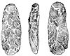
Three views of an adze, from Meayll Hill
-
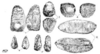
Worked flints found on Meayll Hill
-
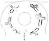
Plan of the Meayll Stone Circle
-
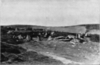
Meayll Stone Circle from the east
-
Meayll Stone Circle, excavated cist
-
Meayll Stone Circle, excavated cist (another view)


