Murillo, Tolima facts for kids
Quick facts for kids
Murillo, Tolima
|
|||
|---|---|---|---|
|
Municipality and town
|
|||
|
|||

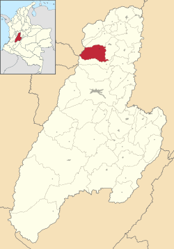
Location of the municipality and town of Murillo, Tolima in the Tolima Department of Colombia.
|
|||
| Country | |||
| Department | Tolima Department | ||
| Aldea | 1887-10-24 | ||
| Area | |||
| • Municipality and town | 417.29 km2 (161.12 sq mi) | ||
| • Urban | 1.0 km2 (0.4 sq mi) | ||
| Elevation | 2,950 m (9,680 ft) | ||
| Population
(2005)
|
|||
| • Municipality and town | 4,953 | ||
| • Density | 11.8694/km2 (30.742/sq mi) | ||
| • Urban | 1,569 | ||
| Time zone | UTC-5 (Colombia Standard Time) | ||
| Website | http://www.murillo-tolima.gov.co/ | ||
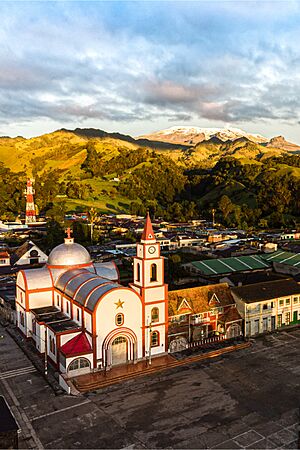
Murillo is a small town and a larger area called a municipality in the Tolima region of Colombia. In 2005, about 4,953 people lived in the whole municipality. Out of these, 1,569 lived right in the town of Murillo, while others lived in the countryside nearby.
Murillo is located about 144 kilometers (about 90 miles) away from Ibagué, which is the capital city of the Tolima region. The municipality of Murillo shares its borders with other towns: Villahermosa to the north, Santa Isabel to the south, and Líbano to the east. To the west, it borders the Caldas and Risaralda regions. Murillo is known for being the highest town in the Tolima department, sitting at an altitude of 2,950 meters (about 9,678 feet) above sea level.
The western edge of the Murillo municipality is home to some very tall mountains. These include the peaks of Nevado del Ruiz, Nevado El Cisne, and Nevado Santa Isabel. These are all volcanoes, making the area very scenic and interesting!
Climate in Murillo
Murillo has a cool and wet climate all year round. This type of weather is called a cold subtropical highland climate. It means that even though it's in a warmer part of the world, the high altitude makes it feel like a cool mountain climate. It rains a lot throughout the year in Murillo.
| Climate data for Murillo | |||||||||||||
|---|---|---|---|---|---|---|---|---|---|---|---|---|---|
| Month | Jan | Feb | Mar | Apr | May | Jun | Jul | Aug | Sep | Oct | Nov | Dec | Year |
| Mean daily maximum °C (°F) | 15.4 (59.7) |
15.7 (60.3) |
15.6 (60.1) |
14.8 (58.6) |
15.0 (59.0) |
14.8 (58.6) |
15.4 (59.7) |
15.0 (59.0) |
15.2 (59.4) |
14.4 (57.9) |
14.7 (58.5) |
15.1 (59.2) |
15.1 (59.2) |
| Daily mean °C (°F) | 10.6 (51.1) |
11.0 (51.8) |
11.1 (52.0) |
10.7 (51.3) |
11.1 (52.0) |
10.9 (51.6) |
11.0 (51.8) |
10.8 (51.4) |
10.8 (51.4) |
10.4 (50.7) |
10.6 (51.1) |
10.6 (51.1) |
10.8 (51.4) |
| Mean daily minimum °C (°F) | 5.9 (42.6) |
6.3 (43.3) |
6.7 (44.1) |
6.6 (43.9) |
7.2 (45.0) |
7.0 (44.6) |
6.7 (44.1) |
6.7 (44.1) |
6.5 (43.7) |
6.4 (43.5) |
6.5 (43.7) |
6.1 (43.0) |
6.6 (43.8) |
| Average rainfall mm (inches) | 108 (4.3) |
116 (4.6) |
152 (6.0) |
252 (9.9) |
247 (9.7) |
169 (6.7) |
122 (4.8) |
133 (5.2) |
204 (8.0) |
244 (9.6) |
220 (8.7) |
133 (5.2) |
2,100 (82.7) |
| Average rainy days | 11 | 12 | 16 | 19 | 19 | 13 | 11 | 11 | 15 | 19 | 18 | 13 | 177 |
See also
 You can also find more information about Murillo (Tolima) in Spanish for kids here: Murillo (Tolima) para niños
 | Percy Lavon Julian |
 | Katherine Johnson |
 | George Washington Carver |
 | Annie Easley |


