Muskegon Heights, Michigan facts for kids
Quick facts for kids
Muskegon Heights, Michigan
|
|
|---|---|

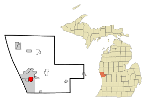
Location in Muskegon County and the state of Michigan
|
|
| Country | United States |
| State | Michigan |
| County | Muskegon |
| Area | |
| • Total | 3.19 sq mi (8.25 km2) |
| • Land | 3.19 sq mi (8.25 km2) |
| • Water | 0.00 sq mi (0.00 km2) |
| Elevation | 623 ft (190 m) |
| Population
(2020)
|
|
| • Total | 9,917 |
| • Density | 3,113.66/sq mi (1,202.05/km2) |
| Time zone | UTC-5 (Eastern (EST)) |
| • Summer (DST) | UTC-4 (EDT) |
| ZIP code |
49444
|
| Area code(s) | 231 |
| FIPS code | 26-56360 |
| GNIS feature ID | 0633165 |
Muskegon Heights is a city located in Muskegon County, in the state of Michigan, United States. It's a vibrant community with a rich history. In 2020, about 9,917 people lived here.
Contents
Exploring Muskegon Heights' Location
Muskegon Heights is found in the southwestern part of Muskegon County. It shares borders with other cities and areas. To the north, you'll find Muskegon. To the south, it borders the city of Norton Shores. A small part of Muskegon Township is on its east side. The city of Roosevelt Park is also very close by, just to the west.
Major Roads and Nearby Cities
A main road, U.S. Route 31, runs along the western edge of Muskegon Heights. This highway is also known as Seaway Drive. If you travel north on U.S. Route 31, you'll reach downtown Muskegon. Going south for about 31 miles (50 km) will take you to Holland. Another big city, Grand Rapids, is about 38 miles (61 km) to the southeast.
Size of the City
Muskegon Heights covers a total area of about 3.19 square miles (8.25 square kilometers). All of this area is land, meaning there are no large lakes or rivers within the city limits.
Understanding Muskegon Heights' Population
The number of people living in Muskegon Heights has changed over the years. Here's a quick look at how the population has grown and shifted:
| Historical population | |||
|---|---|---|---|
| Census | Pop. | %± | |
| 1900 | 1,012 | — | |
| 1910 | 1,690 | 67.0% | |
| 1920 | 9,514 | 463.0% | |
| 1930 | 15,584 | 63.8% | |
| 1940 | 16,047 | 3.0% | |
| 1950 | 18,828 | 17.3% | |
| 1960 | 19,552 | 3.8% | |
| 1970 | 17,304 | −11.5% | |
| 1980 | 14,611 | −15.6% | |
| 1990 | 13,176 | −9.8% | |
| 2000 | 12,049 | −8.6% | |
| 2010 | 10,856 | −9.9% | |
| 2020 | 9,917 | −8.6% | |
| U.S. Decennial Census | |||
Population in 2020
According to the 2020 census, the city had a population of 9,917 people. Most residents identified as African American. There were also many White residents and people of mixed races. A smaller number of people identified as Hispanic or Latino, and they can be of any race.
Population in 2010
Back in 2010, there were 10,856 people living in Muskegon Heights. About 78.3% of the population was African American, and 16.0% was White. Other groups included Native American and Asian residents. About 4.2% of the population was Hispanic or Latino.
Households and Families
In 2010, there were nearly 4,000 households in the city. About 42% of these households had children under 18 living there. The average household had about 2.66 people. The average family size was a bit larger, with about 3.23 people.
Age and Gender
The median age in Muskegon Heights in 2010 was 30.3 years. This means half the population was younger than 30.3, and half was older. About 32% of the residents were under 18 years old. The city had slightly more females (53.7%) than males (46.3%).
See also
 In Spanish: Muskegon Heights para niños

