Mynydd-y-glog facts for kids
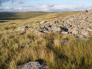
Mynydd-y-glog is a hill located in south Wales, just east of a village called Penderyn. It's part of the Rhondda Cynon Taff area. This hill is special because it sits inside the beautiful Brecon Beacons National Park and the Fforest Fawr Geopark. The very top of Mynydd-y-glog is 389 meters (about 1,277 feet) high. You can find a special marker called a trig point there. To the north, there's a valley called Pant Sychbant, and streams on the southern side flow into the Afon Cynon.
What is Mynydd-y-glog Made Of?
The hill is like a giant layered cake made of different types of rocks. These rocks were formed a very long time ago, during a period called the Carboniferous period.
- Limestone: At the bottom of the hill, you'll find Carboniferous Limestone. This rock is exposed on the northern side.
- Sandstone: Above the limestone is a rough rock called Twrch Sandstone. This also formed during the Carboniferous period.
There are also several faults running across the hill. A fault is like a crack in the Earth's crust where rocks have moved. The limestone in the area creates interesting karst scenery. This includes many shakeholes, which are like natural sinkholes in the ground. You can find these shakeholes in both the limestone and sandstone areas.
Ancient Discoveries on the Hill
People have found several ancient cairns scattered around the slopes of Mynydd-y-glog. A cairn is a pile of stones built by people a very long time ago, often as a monument or burial marker.
How to Explore Mynydd-y-glog
Mynydd-y-glog is an "open access" area, which means you can freely explore it on foot.
- You can start walking from the Cwm Cadlan road near Wernlas, following a public footpath that goes southeast.
- Another way to reach the hill is from the west, using an old railway line near Penderyn.
- You can also get there from the east through the woodlands managed by Natural Resources Wales at Penmoelallt.


