Mynydd Llangatwg facts for kids
Mynydd Llangatwg, also known as Llangattock Mountain, is a large hill in the beautiful Brecon Beacons National Park in south Wales. It's located in the county of Powys. The hill gets its name from the nearby village of Llangatwg, which sits in the River Usk valley to the north.
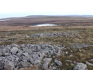
This mountain is mostly a wavy, flat area called a plateau. It rises to about 530 meters (1,739 feet) in the west and 529 meters (1,736 feet) in the east at a spot called Hen Dy-aderyn / Twr Pen-cyrn. You can find a special marker, called a trig point, at this high point. There are also a few small pools on the plateau, like Pwll Gwy-rhoc.
Mynydd Llangatwg has a very steep northern edge, often called the Llangattock Escarpment, which looks out over the Usk valley. The southern parts of the hill are much gentler. To the east, the hill drops sharply into the Clydach Gorge. To the west, past the B4560 road, Mynydd Llangatwg joins up with Mynydd Llangynidr, which looks quite similar.
You'll find some interesting features on the mountain. One is 'The Lonely Shepherd', a tall, thin piece of limestone rock. It was left behind by quarry workers who dug out huge amounts of rock around it. There are also several ancient stone piles, called cairns, scattered across the hill. Two large ones are on the summit of Twr Pen-cyrn and are thought to be from the Neolithic age, thousands of years ago.
A more recent feature was Cairn-Mound Reservoir. This was a small lake built to hold water on the southern slopes. However, Welsh Water stopped using it years ago, and now plants have grown over its bed, though the old dam is still there. You can also see paths where gas pipelines have been laid across the mountain, marked by fences or poles.
Mountain Rocks and Caves
Mynydd Llangatwg is made up of different layers of rock, like a cake. These rocks formed a very long time ago, during the Palaeozoic Era. They include sandstones and limestones, which gently slope southwards towards the South Wales Coalfield.
Along the steep northern edge, you can see impressive cliffs of Carboniferous Limestone. This type of rock is found all under the hill and is home to huge cave systems. Two of the most famous are Ogof y Daren Cilau and Ogof Agen Allwedd. These are some of the longest cave systems in Britain!
The top of the plateau is made of rough sandstones, called 'gritstones', also from the Carboniferous Period. Over thousands of years, the limestone underneath has dissolved, causing the sandstone above to sink in many places. The sandstone that forms lower cliffs above the main northern and eastern edges is called the Twrch Sandstone. Higher up, in the middle of the hill, you'll find the Farewell Rock, which marks the start of the South Wales Coal Measures.
Because there's limestone beneath the sandstone, the hill's surface has many small hollows, like dimples, called shakeholes. These form when the limestone dissolves and the ground above collapses.
Old Quarries and Tramways
For much of the 1800s, the northern edge of Mynydd Llangatwg was a busy place with many limestone quarries. Workers dug out the rock, and then it was moved using special tracks called tramroads or tramways.
These tramways went in different directions:
- North: They connected to a wharf on the Monmouthshire and Brecon Canal at Llangatwg using steep slopes.
- South: Two tramroads went around the eastern end of the hill to Brynmawr and the ironworks at Nant-y-glo.
The upper tramway was built in the early 1800s. It runs south from Pant y Gilwern and then west around the top of Cwm Clydach. Today, this old tramway is a grassy path, making it easy to walk through what would otherwise be rough land. The lower tramway was built a bit later, between 1828 and 1830, and has since been turned into a public road. Both tramways had smaller branches that led to the different quarries along the hillside.
Smaller quarries also existed along the B4560 Beaufort Road, where they dug out Twrch Sandstone and Farewell Rock. There were even larger quarries near the southwestern corner of the hill.
Exploring the Mountain
The B4560 road, which goes from Garnllydan to Llangynidr, crosses the high moorland of Mynydd Llangatwg. This road makes it easy to get onto the hill and also to Mynydd Llangynidr to the west.
Almost the entire hill is considered urban common. This means that, thanks to the Countryside and Rights of Way Act 2000, walkers are free to explore almost anywhere they like. There aren't many marked paths, but one public footpath crosses from north to south, passing just east of the Twr Pen-cyrn summit. The old tramways we talked about earlier also offer easy, flat routes around the edges of the hill.
 | Jackie Robinson |
 | Jack Johnson |
 | Althea Gibson |
 | Arthur Ashe |
 | Muhammad Ali |


