Mynydd Llangynidr facts for kids
Mynydd Llangynidr is a mountain in the Brecon Beacons National Park in south Wales. It's mostly in Powys county, but its lower parts stretch into Blaenau Gwent. The mountain gets its name from the village of Llangynidr, which is in the River Usk valley nearby.
This mountain is like a big, wavy plateau. Its highest point is 557 meters (about 1,827 feet) at a spot called Garn Fawr. Another high point has a trig point, which is a special marker used for surveying. To the north, the mountain looks over the valleys of Dyffryn Crawnon and Cwm Claisfer, which are smaller valleys leading to the Usk River. The upper part of the Ebbw River valley reaches into the mountain from the southeast. The Sirhowy Valley and Nant Trefil define its western edges. To the east, Mynydd Llangynidr connects with Mynydd Llangatwg, which is a similar type of mountain.
Contents
Understanding Mynydd Llangynidr's Rocks
Mynydd Llangynidr is made of different layers of rocks, like a giant cake! These rocks formed a very long time ago, during the Paleozoic Era. They include sandstones and limestones. These layers gently slope southwards, heading towards the South Wales Coalfield basin.
Along the northern edges of the mountain, you can see broken cliffs of Carboniferous Limestone. This type of rock is found underneath the whole mountain. The top part of the mountain, the plateau, is made of rough sandstones, also from the Carboniferous Period. Over thousands of years, the limestone underneath has slowly dissolved. This has caused the sandstone above to sometimes collapse, making the mountain look a bit bumpy.
The mountain's surface has hundreds of small hollows, like dimples, called shakeholes. These form because the limestone beneath the sandstone dissolves, creating holes that the ground above sinks into. The sandstones in the middle and northern parts of the hill are called the Twrch Sandstone. The sandstone found in the southern part is known as the Farewell Rock.
Exploring the Caves
Mynydd Llangynidr is famous for its caves! The most well-known is Ogof Fawr, also called Chartist Cave. People say it was a secret hiding place for the Chartists, who were a group of people fighting for political rights in the 1800s. This cave is about 500 meters east of Garn Fawr.
Another interesting feature is the Carno Adit. This is a long, horizontal tunnel dug into the mountain from the south. It connects with a cave system and has helped scientists learn more about the rocks and how the area was formed. Other caves include Ogof Cynnes (which means 'warm cave') and Crescent Cave, which is not far from Chartist Cave.
Protecting the Mountain: A Special Area
This area is so special that it has been named a Site of Special Scientific Interest (SSSI). This means it's a place that needs to be protected because of its unique natural features. The SSSI was officially recognized in February 2013.
It's protected because of its amazing karst landscape. This is a type of landscape where the dissolving of bedrock (like limestone) creates caves, sinkholes, and underground drainage. The SSSI document says that the area has "the best British example of an interstratal karst," which means it's a top example of how limestone dissolves under other rock layers, creating many dolines (another word for sinkholes). The protected area covers a large space, about 896.8 hectares.
Quarrying on the Mountain
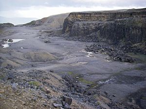
There are a couple of big quarry sites on the mountain. A quarry is a place where rocks are dug out of the ground. There's an active quarry at Trefil, which means it's still being used today. Another one, Blaen Onneu in the northeast, hasn't been used since the 1980s.
You can also find a few smaller, older quarries that were used to dig out limestone before the bigger ones opened. In the past, people also dug for ironstone near the top of Cwm Carneilw before the mid-1800s. There are also some small, abandoned places where sandstone was dug out on the eastern side of the mountain.
Ancient Discoveries: Archaeology
Mynydd Llangynidr is home to many ancient cairns, which are piles of stones built by people long ago. The most famous ones are Garn Fawr ('big cairn') and Carn Caws ('cheese cairn'). These are from prehistoric times.
Near the northern edge of the mountain, you can also find other prehistoric cairns and a line of stones. There's also evidence of house platforms, which are flat areas where ancient houses once stood. These findings help us learn about the people who lived here thousands of years ago.
How to Visit Mynydd Llangynidr
The mountain is considered "open country," which means walkers are free to explore it. There aren't many marked paths, but two public footpaths cross the mountain from north to south, going from Llangynidr towards Tredegar.
The B4560 road, which goes from Garnllydan to Llangynidr, crosses the high moorland on the eastern side of the mountain. This road offers an easy way to reach both Mynydd Llangynidr and Mynydd Llangatwg. To the west, a smaller road goes north from the A465 Heads of the Valleys Road through the village of Trefil. This road then turns into a bridleway (a path for walkers, horse riders, and cyclists), also providing easy access to the mountain.
 | Stephanie Wilson |
 | Charles Bolden |
 | Ronald McNair |
 | Frederick D. Gregory |


