Nanutarra Station facts for kids
Quick facts for kids Nanutarra Station |
|
|---|---|

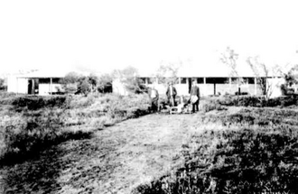
Nanuturra homestead 1909
|
|
| General information | |
| Type | Station |
| Location | 108 kilometres (67 mi) south of Onslow, Pilbara, Western Australia |
| Coordinates | |
| Designated | 4 November 2005 |
| Reference no. | 1743 |
Nanutarra Station, often called Nanutarra, is a very large farm in Western Australia. It is known as a pastoral lease because it's rented land used for grazing animals. This station used to raise sheep, but now it mainly raises cattle.
Contents
Where is Nanutarra Station?
Nanutarra Station is located in the Pilbara region of Western Australia. It is about 108 kilometres (67 miles) south of Onslow. It is also about 156 kilometres (97 miles) southeast of Exmouth.
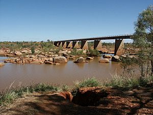
The main road, called the North West Coastal Highway, goes right through the property. You can also find the Nanutarra Roadhouse within the station's boundaries. Two important rivers, the Ashburton River and the Henry River, flow across the land.
Nanutarra Station shares its borders with other large properties. These include Globe Hill to the west, Uaroo and Glenflorrie to the south, and Boolaloo to the north and east.
A Look at Nanutarra's Past
The land that became Nanutarra Station was first used for grazing animals in 1877. A man named Harry Higham brought his animals there. He built the main house, called the homestead, in 1884.
By 1906, Nanutarra Station was home to about 45,000 sheep. It grew so much that by 1919, it was one of the biggest farms in the area.
Harry Higham passed away in 1917. He had managed the station until 1902 before moving to Perth. In 1925, the station was put up for auction (a public sale). At that time, it covered an area of about 319,507 acres (1,293 square kilometres). It had 18 wells for water and lots of fences, dividing the property into 17 different areas for animals. There were 8,617 sheep on the station then.
The Higham family kept the station for a while longer. In 1937, Harry Higham's brothers sold Nanutarra Station, along with another property called Mount Stuart Station. They sold it to the Boololoo Pastoral Company.
Recognized for its History
In 2005, Nanutarra Station received a special honor. It was officially added to the Western Australian Register of Heritage Places. This means it is an important historical site. The station was one of the very first large farms in the northwest of Australia. It played a big part in developing the farming industry in that region.
Today, the Nanutarra lease covers an area of about 1,630 square kilometres (629 square miles). In 2011, an agreement was made about land use. This agreement was between the Buurabalayji Thalanyji Aboriginal Corporation and Nanutarra Grazing Pty Ltd. It followed the rules of the Native Title Act.
In 2012, Nanutarra Station was sold. It was sold together with the nearby Uaroo Station, as they were being managed as one large property. Together, these two stations covered about 4,803 square kilometres (1,854 square miles). They had a herd of about 2,750 cattle. The land has many places where animals can drink water, including 70 specially equipped watering points. There are also many natural waterholes along the rivers and creeks.
Both Nanutarra and Uaroo stations were bought by Andrew Forrest. He is the Chairman of a big mining company called Fortescue Metals Group. Andrew Forrest also owns another large farm called Minderoo Station, which is north of Uaroo.
The Nanutarra Homestead
The main buildings at Nanutarra Station are called the homestead complex. They are a simple example of Victorian-Georgian style. The main building has two separate parts. These parts are connected by a covered area. Some of these buildings were built way back in the 1880s.
Most of the homestead buildings are not in very good condition. They have become damaged over time, mainly because of moisture getting into them. However, these buildings are still considered very original. They are similar to the homesteads found at other stations like Cooya Pooya and Tambrey.
 | Delilah Pierce |
 | Gordon Parks |
 | Augusta Savage |
 | Charles Ethan Porter |


