
Nanyuki facts for kids
Quick facts for kids
Nanyuki
|
|
|---|---|
|
Town
|
|

Nanyuki main street
|
|

Nanyuki
Location in Kenya
|
|
| Country | |
| County | Laikipia County |
| Population
(2019)
|
|
| • Total | 72,813 |
Nanyuki is a busy market town in Laikipia County, Kenya. It is located northwest of Mount Kenya. You can find it along the A2 road and at the end of a railway line from Nairobi. The name Nanyuki comes from a Maasai word meaning "resemblance."
This town is special because it sits just north of the Equator. In 1907, British settlers came to Nanyuki. Some of their families still live there today. Nanyuki is also home to a main airbase for the Kenya Air Force. The British Army Training Unit Kenya (BATUK) has a base nearby. They use the area for training exercises.
Contents
Discovering Nanyuki's Past
The Maasai people, who are herders, first found red ochre in Nanyuki. They thought the ground looked like the coats of roan cattle. That's how the town got its name. In 1907, British settlers made Nanyuki their home. This was during the early days of colonial Kenya. Many of their descendants still live in the area.
A famous British Army officer, Major Digby Tatham-Warter, moved to Nanyuki after World War II. He was known for carrying an umbrella into battle! He lived on his farm until he passed away in 1993. During a time of conflict called the Mau Mau Uprising, Digby helped by forming a volunteer police group. He led them to help keep the peace.
Nanyuki is known for its many farms and ranches. It also has large areas for wildlife. The town is a popular starting point for people who want to climb Mount Kenya. You can even find a sign by the A2 road that marks the Equator.
The Nanyuki Civil Airfield was once used by the No. 1340 Flight RAF. This group flew Harvard planes during the Mau Mau Uprising.
Nanyuki's Weather
Nanyuki usually has cool weather all year round. It gets rain at three different times of the year. January and February are typically the driest months.
| Climate data for Nanyuki | |||||||||||||
|---|---|---|---|---|---|---|---|---|---|---|---|---|---|
| Month | Jan | Feb | Mar | Apr | May | Jun | Jul | Aug | Sep | Oct | Nov | Dec | Year |
| Mean daily maximum °C (°F) | 25 (77) |
26 (79) |
25 (77) |
23 (74) |
23 (73) |
23 (74) |
22 (72) |
23 (73) |
24 (76) |
24 (75) |
23 (73) |
23 (74) |
24 (75) |
| Mean daily minimum °C (°F) | 7 (45) |
8 (47) |
9 (49) |
11 (51) |
10 (50) |
9 (48) |
8 (47) |
8 (47) |
8 (46) |
8 (47) |
9 (49) |
8 (47) |
9 (48) |
| Average precipitation mm (inches) | 13 (0.5) |
23 (0.9) |
46 (1.8) |
120 (4.7) |
81 (3.2) |
51 (2) |
69 (2.7) |
66 (2.6) |
48 (1.9) |
64 (2.5) |
86 (3.4) |
38 (1.5) |
700 (27.5) |
| Source: Weatherbase | |||||||||||||
Life and Business in Nanyuki

In 2019, Nanyuki had an urban population of 72,813 people. Most people in Nanyuki make their living through trade. Shops in the town provide goods for many farms, ranches, and wildlife parks. They also serve the people who live in Nanyuki. In the past, many shops were owned by people of Indian descent. They still make up a good part of the population today.
Many climbers and backpackers visit Nanyuki. They pass through on their way to or from Mount Kenya. Tourists also come to explore the area. Nanyuki has many hotels, like the famous Mount Kenya Safari Club. Other popular places to stay include Sportsman's Arms Hotel and Le Rustique. South of Nanyuki, the Bantu lodge offers fun outdoor activities.
There isn't much large-scale industry in Nanyuki. Some sawmills used to operate here. However, strict rules about cutting trees on Mount Kenya have made it hard for them to continue. Recently, large flower and plant farms have started in the Nanyuki area. These include Likii flower farm and Traco farm. The railway line between Nanyuki and Nairobi has also been reopened. This has helped increase trade in the town. You can find modern shopping centers like Cieni, Cedar Mall, and Quick Mart.
A city park is located in the center of town. Two rivers, the Nanyuki and LikiI Rivers, flow through it. The Equator crosses the southern part of Nanyuki. You will cross it if you drive into Nanyuki from the south on the A2 road. This spot is popular with tourists who like to take photos there. Sometimes, people will show you a trick with draining water. They say it swirls differently on each side of the Equator due to the Coriolis force. However, this effect is usually too small to see outside of a science lab. It's just a fun demonstration!
Exploring Nanyuki: Tourism
The airport is about 6.5 kilometers (4 miles) south of town. It serves small planes. Airlines like Air Kenya and Safarilink have regular flights. This makes it easy for business people and tourists to visit. Nanyuki is also connected by a paved road from Nairobi. This road continues north into other parts of Kenya.
Tourists can visit many parks and reserves near Nanyuki. The most famous is Mount Kenya National Park. The Mount Kenya Wildlife Conservancy is also nearby. It works to protect animals like the endangered bongo. The Fairmont Mount Kenya Safari Club is a luxurious hotel. It offers amazing views of Mount Kenya.
Other great places to visit include:
- Ol Pejeta Conservancy
- Lewa Wildlife Conservancy
- Aberdare National Park
- Samburu National Reserve
- Shaba National Reserve
Nanyuki has some of the cleanest water in Kenya. This is because its water comes directly from Mount Kenya. The entire water system uses gravity to move water from the source to the sewer system.
Learning in Nanyuki: Education
Nanyuki has many schools for students of all ages. Some of the well-known schools include:
- Nanyuki High School
- Moi Equator Girls' High School
- St Christopher's School
- Braeburn International School Nanyuki
- Mt. Kenya Baptist Primary School
- Likii Hill
- Nanyuki Primary School
- Mary Immaculate Primary School
- Baraka School
- Brickwoods School
- St. Jude Nturukuma secondary
- Loise Girls high school
Images for kids
-
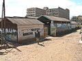
Municipal market
-
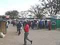
Matatu stage (bus station)
-
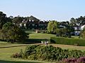
Mount Kenya Safari Club
-
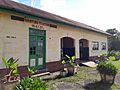
Nanyuki Train Station


.jpg)
See also
 In Spanish: Nanyuki para niños
