Natagaima facts for kids
Quick facts for kids
Natagaima
|
|||
|---|---|---|---|
|
Municipality and town
|
|||
|
|||

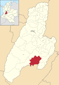
Location of the municipality and town of Natagaima in the Tolima Department of Colombia.
|
|||
| Country | |||
| Department | Tolima Department | ||
| Area | |||
| • Total | 862 km2 (333 sq mi) | ||
| Elevation | 326 m (1,070 ft) | ||
| Population
(2017)
|
|||
| • Total | 22,455 | ||
| Time zone | UTC-5 (Colombia Standard Time) | ||
Natagaima (pronounced nata-GAH-ee-ma) is a town and municipality in Colombia. It is located in the Tolima Department, right by the Magdalena River. The town is about 326 meters (1,070 feet) above sea level.
The average temperature in Natagaima is around 26°C (79°F). In 2017, about 22,455 people lived in the municipality. A Spanish explorer named Juan de Borja founded Natagaima in 1606.
Contents
What's in a Name?
The name Natagaima has a couple of interesting stories. Some people think it comes from two words: "Nataga" (meaning "Chief") and "Ima" (meaning "land").
Another idea is that the name came from a local chief named Nataga. He was said to have married Queen Ima, who was a ruler of other chiefs in the center of Tolima.
Where is Natagaima?
Natagaima is located in the Tolima Department. It shares borders with several other towns:
- To the north: Coyaima and Prado
- To the east: Dolores and Alpujarra
- To the west: Ataco and Coyaima
- To the south: Aipe (which is in the Huila Department)
The capital city of Tolima, Ibagué, is about 118 kilometers (73 miles) away from Natagaima.
People and Jobs
About 26,600 people live in Natagaima, which covers an area of 862 square kilometers (333 square miles). The main way people make a living here is through farming. The warm weather helps grow crops like rice, cotton, corn, and sorghum.
Raising livestock, especially a type of cattle called Zebu, is also very important to the local economy. People in Natagaima also work in crafts and making leather goods like saddles.
A Look at History
The area of Natagaima was first home to the Pijao Indians. These included the Natagaima and Coyaima communities. They were strong warriors and fought hard against the Spanish invaders. The Spanish, led by Juan de Borja, eventually took control.
It is believed that Natagaima was not always in its current spot. It was moved to its present location in 1801 by a priest named Ignacio Navarro. For a few years, from 1863 to 1866, Natagaima was even the capital of the Sovereign State of Tolima.
On February 21, 1963, Natagaima officially became a municipality. It started its role as a local government on January 1, 1964.
The Pijao Indians, especially the Natagaima and Coyaima groups, were very brave. They resisted the Spanish invasion fiercely. Other local tribes, like the Dujos and Babadujos, often fought against the Natagaimas and Coyaimas. Because of many attacks, these tribes eventually decided to support the Spanish instead.
Yummy Local Foods
Natagaima has many delicious traditional dishes. Some of the most important ones include:
- Tamale (Tolimense): A dish made of corn dough, meat, and vegetables, wrapped in plantain leaves and steamed.
- Almojábana: A type of cheese bread.
- Yucca bread with oats: A tasty bread made from yucca (cassava) flour.
- Lechona: A whole roasted pig stuffed with rice, peas, and spices.
- Bizcochuelo: A light sponge cake.
- Mistela: A traditional drink.
- Chanfaina: A stew made with offal.
- Corn Chicha: A fermented corn drink.
- Masato: Another traditional fermented drink, often made from rice or corn.
- Poporoi: A local snack.
Famous Songs and Dances
During local celebrations, people often dance to traditional songs. Some well-known songs include "La caña" (by Cantalicio Rojas), "El contrabandista," and "El pasamanos."
Cool Places to Visit
Natagaima has several interesting places to explore:
- Pacandé Mountain: A beautiful mountain in the area.
- The Painima Bath Zone: A place where people can swim and relax.
- The Patá (la Palmita) Bath Zone: Another popular swimming spot.
- The Anchique River: A river that flows through the region.
- The Hipogeo Indian Cemetery: An ancient burial site located in the Palma Alta area.
- The Magdalena River crossing: A significant point where the Magdalena River can be crossed.
Schools in Natagaima
Natagaima has several schools for different age groups.
Primary Schools
- 1 May Urban Mixed School
- Maria Auxiliadora Urban Mixed School
- Gabriel Rebeis Pizarro Urban Mixed School
- Gustavo Perdomo Ávila Urban Mixed School
Secondary Schools
- Francisco José de Caldas School
- Alfonzo Reyes Echandia School
- Luis Carlos Galan Sarmiento School
Rural Schools
- Rural and Agricultural Development School Anchique
- Policarpa Salavarrieta Basic Education Institute
- La Palmita Rural Mixed School
- New Town Adult Centre
- Mariano Ospina Perez Institute
Notable People
Some famous people come from Natagaima:
- Teófilo Forero: A politician and leader in trade unions.
- Rafael Godoy: A well-known composer.
- Cantalicio Rojas: A famous musician and composer.
- India Meliyara: A notable figure.
Climate
| Climate data for Natagaima (Anchique), elevation 415 m (1,362 ft), (1981–2010) | |||||||||||||
|---|---|---|---|---|---|---|---|---|---|---|---|---|---|
| Month | Jan | Feb | Mar | Apr | May | Jun | Jul | Aug | Sep | Oct | Nov | Dec | Year |
| Mean daily maximum °C (°F) | 33.5 (92.3) |
33.8 (92.8) |
33.2 (91.8) |
32.6 (90.7) |
33.0 (91.4) |
34.3 (93.7) |
35.3 (95.5) |
36.6 (97.9) |
35.8 (96.4) |
33.2 (91.8) |
31.3 (88.3) |
31.6 (88.9) |
33.7 (92.7) |
| Daily mean °C (°F) | 27.7 (81.9) |
28.1 (82.6) |
27.8 (82.0) |
27.4 (81.3) |
27.5 (81.5) |
28.2 (82.8) |
29.0 (84.2) |
30.0 (86.0) |
29.5 (85.1) |
27.8 (82.0) |
26.7 (80.1) |
26.9 (80.4) |
28.1 (82.6) |
| Mean daily minimum °C (°F) | 23.0 (73.4) |
23.1 (73.6) |
23.1 (73.6) |
23.1 (73.6) |
23.0 (73.4) |
23.3 (73.9) |
23.6 (74.5) |
24.0 (75.2) |
23.7 (74.7) |
23.0 (73.4) |
22.8 (73.0) |
22.8 (73.0) |
23.2 (73.8) |
| Average precipitation mm (inches) | 100.1 (3.94) |
123.8 (4.87) |
152.1 (5.99) |
181.9 (7.16) |
129.7 (5.11) |
38.1 (1.50) |
42.3 (1.67) |
32.4 (1.28) |
76.8 (3.02) |
212.0 (8.35) |
242.4 (9.54) |
162.3 (6.39) |
1,493.9 (58.81) |
| Average precipitation days | 9 | 11 | 13 | 14 | 14 | 9 | 8 | 6 | 8 | 15 | 16 | 13 | 135 |
| Average relative humidity (%) | 73 | 71 | 73 | 75 | 74 | 66 | 60 | 55 | 60 | 70 | 78 | 77 | 69 |
| Mean monthly sunshine hours | 229.4 | 186.3 | 179.8 | 174.0 | 195.3 | 192.0 | 210.8 | 210.8 | 195.0 | 195.3 | 189.0 | 210.8 | 2,368.5 |
| Mean daily sunshine hours | 7.4 | 6.6 | 5.8 | 5.8 | 6.3 | 6.4 | 6.8 | 6.8 | 6.5 | 6.3 | 6.3 | 6.8 | 6.5 |
| Source: Instituto de Hidrologia Meteorologia y Estudios Ambientales | |||||||||||||
See also
 In Spanish: Natagaima para niños
 | Dorothy Vaughan |
 | Charles Henry Turner |
 | Hildrus Poindexter |
 | Henry Cecil McBay |


