Aipe facts for kids
Quick facts for kids
Aipe
|
||
|---|---|---|
|
Municipality and town
|
||
|
||

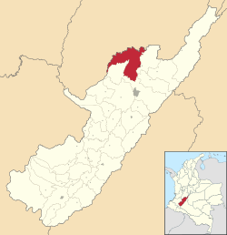
Location of the municipality and town of Aipe in the Huila Department of Colombia
|
||
| Country | ||
| Department | Huila Department | |
| Subregion | Subnorte | |
| Founded | 2 January 1741 | |
| Founded by | Teresa & Enrique Cortés | |
| Area | ||
| • Municipality and town | 801.04 km2 (309.28 sq mi) | |
| Elevation | 350 m (1,150 ft) | |
| Population
(2015)
|
||
| • Municipality and town | 26,219 | |
| • Density | 32.7312/km2 (84.7734/sq mi) | |
| • Urban | 16,530 | |
| Time zone | UTC-5 (Colombia Standard Time) | |
Aipe is a town and municipality in the Huila Department, Colombia. It is located on the west bank of the Magdalena River. This area is part of the Central Ranges of the Colombian Andes mountains. Aipe sits at different heights, from about 350 meters (1,150 feet) to 2,300 meters (7,500 feet) above sea level.
Aipe shares its borders with several other places. To the north and west, it borders Natagaima, Ataco, and Planadas in the Tolima Department. To the east, it borders Villavieja and Tello. To the south, it is next to Neiva, which is the capital city of the Huila Department.
Contents
History of Aipe
Founding the Town
Aipe was founded a long time ago, in early 1741. Two people, Doña Teresa and Don Enríque Cortés, are known as its founders. They were descendants of Mr. Jacinto Cortés. They gave 80 hectares (about 200 acres) of land to start this new town.
Early Developments
By 1770, important records in Neiva show that a church was built in Aipe. This church was dedicated to "Our Lady of Sorrows." This shows that the town was growing and becoming an important community.
Becoming a Municipality
Aipe gained more independence in 1874. It became a part of the canton district of Villavieja. Then, on April 8, 1912, Aipe officially became its own municipality. This means it became a self-governing area within the Huila Department.
Geography of Aipe
Location and Borders
The municipality of Aipe is located on the left bank of the Magdalena River. It is in the northwest part of the Huila Department. This area is within the Magdalena Valley. To the north and west, Aipe borders the Tolima Department. The Magdalena River forms its eastern border. To the south, it borders Neiva, the capital of Huila.
Size and Elevation
Aipe covers a total area of 801.04 square kilometers (about 309 square miles). This is about 3.8% of the entire Huila Department. The lowest part of Aipe is along the banks of the Magdalena River. Here, the altitude is about 350 meters (1,150 feet) above sea level. The average temperature in this lower area is around 28.4°C (83.1°F).
The highest point in Aipe is much higher, at about 2,300 meters (7,500 feet) above sea level. This high point is in an area called "vereda La Union," near the border with the Tolima Department. In these higher parts, the average temperature is cooler, around 13.67°C (56.6°F).
Ancient Life in Aipe
Discovering Fossils
Aipe is a special place for learning about ancient life! In some of its rock formations, like the Loma Gorda and Hondita Formations, scientists have found many fossils. These fossils are from the Late Cretaceous period, which was a very long time ago.
What Fossils Are Found?
Most of the fossils found here are from ancient sea creatures called ammonites. Ammonites were like squids living inside a spiral shell, similar to a modern-day nautilus. They swam in the oceans that covered this area millions of years ago. Finding these fossils helps us understand what the world was like in Colombia during the time of the dinosaurs.
Climate
| Climate data for Villavieja/Aipe, elevation 430 m (1,410 ft), (1981–2010) | |||||||||||||
|---|---|---|---|---|---|---|---|---|---|---|---|---|---|
| Month | Jan | Feb | Mar | Apr | May | Jun | Jul | Aug | Sep | Oct | Nov | Dec | Year |
| Mean daily maximum °C (°F) | 34.0 (93.2) |
34.3 (93.7) |
33.6 (92.5) |
33.2 (91.8) |
33.4 (92.1) |
34.2 (93.6) |
34.7 (94.5) |
35.6 (96.1) |
35.7 (96.3) |
34.0 (93.2) |
32.4 (90.3) |
32.7 (90.9) |
34.0 (93.2) |
| Daily mean °C (°F) | 27.8 (82.0) |
28.0 (82.4) |
27.7 (81.9) |
27.5 (81.5) |
27.5 (81.5) |
27.8 (82.0) |
28.0 (82.4) |
28.7 (83.7) |
28.8 (83.8) |
27.6 (81.7) |
26.9 (80.4) |
27.2 (81.0) |
27.8 (82.0) |
| Mean daily minimum °C (°F) | 22.0 (71.6) |
22.2 (72.0) |
22.2 (72.0) |
22.1 (71.8) |
22.0 (71.6) |
21.6 (70.9) |
21.6 (70.9) |
22.1 (71.8) |
22.4 (72.3) |
22.1 (71.8) |
22.0 (71.6) |
22.0 (71.6) |
22.0 (71.6) |
| Average precipitation mm (inches) | 67.0 (2.64) |
88.0 (3.46) |
128.8 (5.07) |
131.2 (5.17) |
95.2 (3.75) |
29.4 (1.16) |
29.8 (1.17) |
20.2 (0.80) |
66.7 (2.63) |
158.9 (6.26) |
183.6 (7.23) |
129.8 (5.11) |
1,128.5 (44.43) |
| Average precipitation days | 8 | 9 | 12 | 14 | 13 | 10 | 9 | 7 | 9 | 15 | 15 | 12 | 131 |
| Average relative humidity (%) | 71 | 70 | 72 | 73 | 72 | 69 | 65 | 61 | 62 | 69 | 75 | 74 | 69 |
| Source: Instituto de Hidrologia Meteorologia y Estudios Ambientales | |||||||||||||
See Also
 In Spanish: Aipe para niños
 | Roy Wilkins |
 | John Lewis |
 | Linda Carol Brown |


