
Ibagué facts for kids
Quick facts for kids
Ibagué
|
|||
|---|---|---|---|
   .jpg)  From the top: Panorama of Ibagué from the east, Ibagué's city hall, Governorate of Tolima, Ocobos flowered in front of the Cathedral of Ibague and Art Museum of Tolima.
|
|||
|
|||
| Nickname(s):
Ciudad musical de Colombia (Musical city of Colombia)
|
|||

Location of the city of Ibagué in Tolima.
|
|||

Ibagué
Location in Colombia
|
|||
| Country | |||
| Region | Andean Region | ||
| Department | Department of Tolima | ||
| Foundation | 14 October 1550 | ||
| Area | |||
| • Municipio | 1,498 km2 (578 sq mi) | ||
| • Urban | 47.96 km2 (18.52 sq mi) | ||
| Elevation | 1,285 m (4,216 ft) | ||
| Population
(2018)
|
|||
| • Municipio | 529,635 | ||
| • Urban | 492,554 | ||
| • Urban density | 10,270.1/km2 (26,599.4/sq mi) | ||
| • Rural | 37,081 | ||
| Demonym(s) | Ibaguereño, ibaguereña | ||
| Time zone | UTC-5 (Eastern Time Zone) | ||
| Postal code |
730001-730019
|
||
| Area code(s) | 57 + 8 | ||


Ibagué is a major city in Colombia. It is the capital of the Tolima region. The city is located in the middle of the country. You can find it in the central Andes mountains, close to a volcano called Nevado del Tolima.
Ibagué is one of Colombia's biggest cities. In 2018, about 492,554 people lived in the city area. If you count the nearby rural areas, the population was 529,625. A Spanish captain named Andrés López de Galarza founded Ibagué on October 14, 1550. The city is divided into 13 main areas, plus 17 rural areas. As the capital, Ibagué is where the government of Tolima works. It's also a hub for business, art, culture, and tourism.
The World Trade Center Association (WTCA) chose Ibagué as one of three cities in Colombia for a new office. The city's economy relies on industry, tourism, and farming. Its textile industry is the third largest in Colombia. According to the World Bank, Ibagué is one of the easiest cities in Colombia to start a business. It is also part of the important coffee-growing region.
Ibagué is famous as "The Musical Capital of Colombia and America." This is because of the Conservatory of Tolima, a very important music school. The city also has many music-themed monuments and holds lively folklore festivals. Besides the Conservatory, other main schools are the University of Tolima and the University of Ibagué.
Contents
History of Ibagué
Andrés López de Galarza founded Ibagué on October 14, 1550. He first called it "Villa de San Bonifacio de Ibagué del Valle de las Lanzas." This first location was near where the town of Cajamarca is today. It was about 42 kilometers (26 miles) west of Ibagué's current spot.
The local Pijaos people, led by their chief Ibagué, did not want the Spanish to settle there. So, the city was moved and re-founded on February 7, 1551. This new location is where Ibagué stands today.
For a short time, from April to December 1854, Ibagué was the capital of New Granada. This happened after a military takeover. In 1908, when the Tolima region was created, Ibagué became its capital. The University of Tolima started in 1945 and became a state university in 1954. The city is also home to the main church for the Catholic Church in the area.
Geography and Nature
Ibagué is in the Andean region of Colombia. It is in the center of the Tolima department. Mountains surround the city on most sides. To the east, there is a flat area.
Volcanoes Near Ibagué
Ibagué is located in an area with volcanoes. Two active volcanoes are close by. One is the Nevado del Tolima, about 28 kilometers (17 miles) northwest of the city. The other is Cerro Machín, about 17 kilometers (11 miles) west of the city center. Both are part of the Ibagué area.
Cerro Machín has been quiet for about 800 years. However, scientists have recently seen some small earthquakes there. Experts say that even if Cerro Machín were to erupt, Ibagué would likely not be affected. The city is also a way to enter Los Nevados National Park, a beautiful natural area.
Population of Ibagué
The total number of people living in Ibagué, including both city and rural areas, was 529,635 in 2018. Most of these people, 492,554, lived in the main city area.

Getting Around Ibagué
Transportation
Local bus companies manage public transport in Ibagué. They operate minibuses that travel throughout the city. These buses also go to nearby villages.
Ibagué is located where two main national roads meet. Road 40 and Road 43 connect the city to other important places. You can travel east to the Magdalena River Valley and Bogotá. To the west, you can go to Armenia and the Valle del Cauca. To the north, you can reach Honda.
The city has a large bus terminal. From here, you can find buses to most big cities in Colombia. There are many buses to Bogotá, Cali, and Medellín. You can also find overnight buses to Cartagena, Barranquilla, and sometimes to Santa Marta.
About 10 kilometers (6 miles) east of Ibagué is Perales Airport. This airport has several flights each day to Bogotá and Medellín.
Climate in Ibagué
Ibagué has a tropical rainforest climate. This means it's generally warm and rainy all year. Because the city is high up in the mountains, it's a bit cooler than other tropical places. Even though some months are a little drier, it rains more than 60 millimeters (2.4 inches) every month.
Temperatures in Ibagué stay pretty steady throughout the year. The average high temperature is about 28°C (82°F). The average low temperature is around 18°C (64°F). On average, Ibagué receives about 1700 millimeters (67 inches) of rain each year.
| Climate data for Ibagué (Chapeton), elevation 1,300 m (4,300 ft), (1971–2000) | |||||||||||||
|---|---|---|---|---|---|---|---|---|---|---|---|---|---|
| Month | Jan | Feb | Mar | Apr | May | Jun | Jul | Aug | Sep | Oct | Nov | Dec | Year |
| Mean daily maximum °C (°F) | 25.7 (78.3) |
26.0 (78.8) |
25.9 (78.6) |
25.4 (77.7) |
25.6 (78.1) |
25.9 (78.6) |
26.5 (79.7) |
26.9 (80.4) |
26.5 (79.7) |
25.4 (77.7) |
25.2 (77.4) |
25.3 (77.5) |
25.8 (78.4) |
| Daily mean °C (°F) | 20.3 (68.5) |
20.6 (69.1) |
20.9 (69.6) |
20.6 (69.1) |
20.7 (69.3) |
20.8 (69.4) |
20.9 (69.6) |
21.1 (70.0) |
20.9 (69.6) |
20.3 (68.5) |
20.2 (68.4) |
20.2 (68.4) |
20.6 (69.1) |
| Mean daily minimum °C (°F) | 15.7 (60.3) |
16.1 (61.0) |
16.5 (61.7) |
16.4 (61.5) |
16.5 (61.7) |
16.1 (61.0) |
15.7 (60.3) |
16.0 (60.8) |
16.1 (61.0) |
16.1 (61.0) |
16.1 (61.0) |
15.7 (60.3) |
16.1 (61.0) |
| Average precipitation mm (inches) | 101.9 (4.01) |
114.2 (4.50) |
154.4 (6.08) |
212.8 (8.38) |
249.6 (9.83) |
158.8 (6.25) |
93.1 (3.67) |
111.6 (4.39) |
183.2 (7.21) |
219.6 (8.65) |
212.5 (8.37) |
133.7 (5.26) |
1,945.4 (76.59) |
| Average precipitation days | 14 | 14 | 19 | 22 | 22 | 17 | 13 | 13 | 17 | 21 | 22 | 17 | 211 |
| Average relative humidity (%) | 81 | 81 | 82 | 83 | 83 | 79 | 74 | 73 | 77 | 83 | 85 | 83 | 80 |
| Mean monthly sunshine hours | 158.1 | 124.4 | 130.2 | 117.0 | 145.7 | 159.0 | 176.7 | 170.5 | 153.0 | 124.0 | 126.0 | 139.5 | 1,724.1 |
| Mean daily sunshine hours | 5.1 | 4.4 | 4.2 | 3.9 | 4.7 | 5.3 | 5.7 | 5.5 | 5.1 | 4.0 | 4.2 | 4.5 | 4.7 |
| Source: Instituto de Hidrologia Meteorologia y Estudios Ambientales | |||||||||||||
| Climate data for Ibagué, Colombia (Perales Airport), elevation 928 m (3,045 ft), (1991–2020) | |||||||||||||
|---|---|---|---|---|---|---|---|---|---|---|---|---|---|
| Month | Jan | Feb | Mar | Apr | May | Jun | Jul | Aug | Sep | Oct | Nov | Dec | Year |
| Record high °C (°F) | 34.4 (93.9) |
35.4 (95.7) |
34.4 (93.9) |
34.2 (93.6) |
33.2 (91.8) |
33.6 (92.5) |
35.0 (95.0) |
36.4 (97.5) |
36.0 (96.8) |
34.8 (94.6) |
31.9 (89.4) |
34.2 (93.6) |
36.4 (97.5) |
| Mean daily maximum °C (°F) | 29.2 (84.6) |
29.5 (85.1) |
28.9 (84.0) |
28.6 (83.5) |
28.6 (83.5) |
29.2 (84.6) |
30.4 (86.7) |
31.6 (88.9) |
30.8 (87.4) |
28.9 (84.0) |
27.8 (82.0) |
28.4 (83.1) |
29.3 (84.7) |
| Daily mean °C (°F) | 23.9 (75.0) |
24.3 (75.7) |
24.0 (75.2) |
23.8 (74.8) |
23.8 (74.8) |
24.2 (75.6) |
24.7 (76.5) |
25.4 (77.7) |
24.9 (76.8) |
23.7 (74.7) |
23.1 (73.6) |
23.5 (74.3) |
24.1 (75.4) |
| Mean daily minimum °C (°F) | 19.2 (66.6) |
19.5 (67.1) |
19.5 (67.1) |
19.4 (66.9) |
19.5 (67.1) |
19.2 (66.6) |
19.2 (66.6) |
19.5 (67.1) |
19.2 (66.6) |
19.1 (66.4) |
19.2 (66.6) |
19.2 (66.6) |
19.3 (66.7) |
| Record low °C (°F) | 15.3 (59.5) |
15.2 (59.4) |
14.8 (58.6) |
15.6 (60.1) |
16.2 (61.2) |
15.2 (59.4) |
15.2 (59.4) |
10.6 (51.1) |
14.4 (57.9) |
16.0 (60.8) |
15.2 (59.4) |
15.4 (59.7) |
10.6 (51.1) |
| Average precipitation mm (inches) | 86.0 (3.39) |
105.9 (4.17) |
160.3 (6.31) |
230.2 (9.06) |
220.7 (8.69) |
99.1 (3.90) |
67.4 (2.65) |
60.8 (2.39) |
124.7 (4.91) |
189.1 (7.44) |
173.1 (6.81) |
110.5 (4.35) |
1,627.7 (64.08) |
| Average precipitation days (≥ 1 mm) | 8.8 | 9.9 | 13.3 | 15.5 | 14.9 | 8.5 | 6.9 | 5.7 | 10.3 | 14.4 | 14.1 | 11.1 | 133.5 |
| Average relative humidity (%) | 77 | 77 | 79 | 81 | 81 | 77 | 70 | 66 | 72 | 80 | 83 | 81 | 77 |
| Mean monthly sunshine hours | 179.8 | 144.0 | 139.5 | 138.0 | 155.0 | 168.0 | 192.2 | 195.3 | 180.0 | 158.1 | 141.0 | 164.3 | 1,955.2 |
| Mean daily sunshine hours | 5.8 | 5.1 | 4.5 | 4.6 | 5.0 | 5.6 | 6.2 | 6.3 | 6.0 | 5.1 | 4.7 | 5.3 | 5.4 |
| Source: Instituto de Hidrologia Meteorologia y Estudios Ambientales (humidity, sun 1971-2010) | |||||||||||||
| Climate data for Ibagué (Perales Hato Opia), elevation 700 m (2,300 ft), (1981–2010) | |||||||||||||
|---|---|---|---|---|---|---|---|---|---|---|---|---|---|
| Month | Jan | Feb | Mar | Apr | May | Jun | Jul | Aug | Sep | Oct | Nov | Dec | Year |
| Mean daily maximum °C (°F) | 30.4 (86.7) |
30.5 (86.9) |
30.1 (86.2) |
29.4 (84.9) |
29.2 (84.6) |
29.9 (85.8) |
31.1 (88.0) |
32.4 (90.3) |
31.1 (88.0) |
29.3 (84.7) |
28.9 (84.0) |
29.5 (85.1) |
30.2 (86.4) |
| Daily mean °C (°F) | 25.3 (77.5) |
25.2 (77.4) |
25.1 (77.2) |
24.7 (76.5) |
24.8 (76.6) |
25.1 (77.2) |
25.7 (78.3) |
26.4 (79.5) |
25.8 (78.4) |
24.8 (76.6) |
24.4 (75.9) |
24.7 (76.5) |
25.2 (77.4) |
| Mean daily minimum °C (°F) | 19.2 (66.6) |
19.7 (67.5) |
19.9 (67.8) |
19.9 (67.8) |
19.7 (67.5) |
19.6 (67.3) |
19.4 (66.9) |
19.6 (67.3) |
19.5 (67.1) |
19.5 (67.1) |
19.5 (67.1) |
19.5 (67.1) |
19.6 (67.3) |
| Average precipitation mm (inches) | 63.0 (2.48) |
72.6 (2.86) |
115.1 (4.53) |
200.7 (7.90) |
212.9 (8.38) |
92.4 (3.64) |
62.5 (2.46) |
74.9 (2.95) |
152.9 (6.02) |
170.9 (6.73) |
125.7 (4.95) |
78.1 (3.07) |
1,421.6 (55.97) |
| Average precipitation days | 8 | 9 | 11 | 16 | 16 | 10 | 8 | 7 | 12 | 16 | 13 | 10 | 136 |
| Average relative humidity (%) | 76 | 77 | 78 | 81 | 81 | 77 | 71 | 69 | 73 | 79 | 81 | 79 | 77 |
| Mean monthly sunshine hours | 182.9 | 146.8 | 142.6 | 135.0 | 158.1 | 171.0 | 195.3 | 198.4 | 174.0 | 158.1 | 144.0 | 170.5 | 1,976.7 |
| Mean daily sunshine hours | 5.9 | 5.2 | 4.6 | 4.5 | 5.1 | 5.7 | 6.3 | 6.4 | 5.8 | 5.1 | 4.8 | 5.5 | 5.4 |
| Source: Instituto de Hidrologia Meteorologia y Estudios Ambientales | |||||||||||||
Sports in Ibagué
Ibagué is home to a professional soccer team called Deportes Tolima. This team has won the Liga BetPlay three times. They won in 2003, 2018, and 2021. Club Deportes Tolima was started on December 18, 1954. Jorge Guzmán Molina helped the team achieve its first second-place finish in 1957.
Sister Cities
Ibagué is connected with other cities around the world. These are called "sister cities."
 Chengdu, China
 Vitoria-Gasteiz, Spain
Images for kids
-
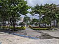
Plaza de Bolívar, the city's main park.
See also
 In Spanish: Ibagué para niños
