
National Register of Historic Places listings in Amador County, California facts for kids

Have you ever wondered about old buildings and places that tell a story? In Amador County, California, there are many special spots that are officially recognized for their history! These places are listed on the National Register of Historic Places. It's like a special list kept by the United States government to protect and celebrate important buildings, sites, and objects.
Amador County is in California, and it has 21 places on this important list. Each one helps us learn about the past and the people who lived here long ago.
Exploring Amador County's Historic Treasures
Let's take a look at some of the amazing historic places you can find in Amador County. These sites are like windows into the past, showing us how people lived, worked, and built communities.
Historic Buildings in Jackson
Jackson, California is home to many of Amador County's historic buildings.
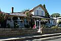
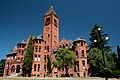
- Amador County Hospital Building: This old hospital building, located at 708 Court Street, was added to the list in 1972. It reminds us of how healthcare was provided in the past.
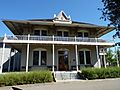
- John A. Butterfield House: Found at 115 Broadway, this house became historic in 1986. It's named after John A. Butterfield, an important person in the area's history.
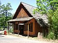
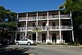
- Chichizola Family Store Complex: This group of buildings at 1316-1330 Jackson Gate Road was recognized in 1992. It shows us what family businesses and stores were like long ago.
- Grace Blair DePue House and Indian Museum: At 215 Court Street, this house and museum was listed in 1982. It's a place where you can learn about the history of Native American people in the region.
- Jackson Downtown Historic District: The heart of downtown Jackson, mainly along Main Street, was added to the list in 2000. This area has many old buildings that show what the town looked like during its early days.
- William J. Paugh House: Located at 406 Pitt Street, this house became historic in 2007. It's a great example of the architecture from its time.
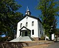
- Saint Sava Serbian Orthodox Church: This beautiful church at 724 N. Main Street was listed in 1986. It's an important place for the Serbian community and a lovely example of historic church architecture.
Mining History and Industry
Amador County has a rich history tied to mining, especially during the California Gold Rush.
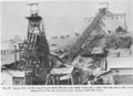
- Kennedy Mine Historic District: Found at 12594 Kennedy Mine Road in Jackson, this entire mining area was listed in 2009. It was once one of the deepest and richest gold mines in the world! You can still see parts of the old mine today.
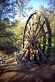
- Kennedy Tailing Wheels: Also in Jackson, on Jackson Gate Road, these giant wheels were added to the list in 1981. They were used to move leftover mining materials (called "tailings") away from the mine. They are huge and very impressive!
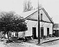
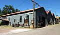
- Knight's Foundry and Shops: In Sutter Creek, California, at 13 Eureka Street, this foundry was listed in 1975. It's the last water-powered foundry and machine shop in the United States! It made and repaired tools and parts for the mines and other industries.
Historic Sites in Ione
The city of Ione, California also has several important historic places.
- Five Mile Drive-Sutter Creek Bridge: This historic bridge on Five Mile Drive was recognized in 1986. Bridges are important for connecting communities and showing how people traveled.
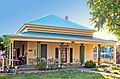
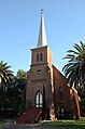
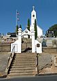
- Ione City Centenary Church: At 150 W. Marlette Street, this church was listed in 1977. It's a beautiful old church that has been a part of the Ione community for a very long time.
- Preston Castle: Located north of Ione on Preston Avenue, this impressive building was added to the list in 1975. It was originally the Preston School of Industry, a reform school for boys, and looks like a real castle!
- Scully Ranch: This historic ranch on Marlette Street was listed in 1978. Ranches played a big part in the development of California.
- C.W. Swain House: At 311 Church and 330 Buena Vista Streets, this house was added to the list in 2014.
- George and Eliza Withington House: Located at 10 Welch Lane, this house became historic in 2015.
Other Notable Historic Places
Amador County has other unique historic sites scattered across its landscape.
- Fiddletown: This entire historic district, located off CA 49, was listed in 1978. Fiddletown is a small, charming town with a lot of history, especially from the Gold Rush era.
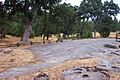
- Indian Grinding Rock State Historic Park: Near Volcano, California, this park was recognized in 1971. It's a very important site for Native American history, featuring large rocks with many holes where acorns and other foods were ground.
- Kirkwood Lake Tract: About half a mile north of California State Route 88, along the shoreline of Lake Kirkwood, this area was listed in 2010. It's a beautiful natural area with historic significance.
- St. George Hotel: In Volcano, California, at 2 Main Street, this hotel was added to the list in 1984. It's a classic old hotel that has welcomed travelers for many years.
- Sutter Creek Grammar School: In Sutter Creek, California, between Broad and Cole Streets, this old school building was listed in 1976. It reminds us of how education has changed over time.
Images for kids
-
Amador County Hospital Building
-
John A. Butterfield House
-
Chichizola Family Store Complex
-
Grace Blair DePue House and Indian Museum
-
Fiddletown
-
Indian Grinding Rock State Historic Park
-
Ione City Centenary Church
-
Jackson Downtown Historic District
-
Kennedy Mine Historic District
-
Kennedy Tailing Wheels
-
Knight's Foundry and Shops
-
William J. Paugh House
-
Preston Castle
-
Saint Sava Serbian Orthodox Church
-
St. George Hotel
-
Sutter Creek Grammar School


.jpg)


.jpg)


