
National Register of Historic Places listings in Anderson County, Tennessee facts for kids

Have you ever wondered about the oldest and most special buildings and places in your community? In Anderson County, Tennessee, there's a list of these important spots! It's called the National Register of Historic Places. This list helps protect buildings, sites, and objects that are important to the history of the United States.
When a place is added to this list, it means it has a unique story to tell about the past. It could be a house where someone famous lived, a church that's very old, or even a whole neighborhood that shows how people used to live. Anderson County has 19 places on this special list, plus one that used to be listed.
This article will tell you about some of these amazing historic places in Anderson County. You can even see their locations on a map if you're interested in exploring!
Historic Places in Anderson County
Anderson County is home to many fascinating places that tell stories from long ago. Each one has been recognized for its special history or architecture.
Norris Area Historic Sites
The town of Norris has several places on the National Register, including parts of the town itself!
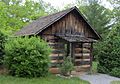
Arnwine Cabin
The Arnwine Cabin is a very old log cabin located on State Route 61 in Norris. It's now part of the Museum of Appalachia, which is a museum dedicated to showing what life was like in the Appalachian mountains. This cabin helps us understand how people lived many years ago.
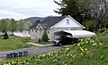
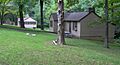
Norris Dam State Park Rustic Cabins Historic District
Located at 125 Village Green Circle in Rocky Top, this area includes old cabins built in a rustic style. They are part of Norris Dam State Park, which is a beautiful place to visit. These cabins show how people used to build vacation spots that blended in with nature.
Norris District
The entire city of Norris, especially the older parts along U.S. Route 441, is recognized as a historic district. This means that many buildings and the way the town is laid out are important to history. Norris was one of the first planned communities built by the Tennessee Valley Authority (TVA) in the 1930s.
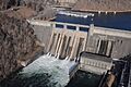
Norris Hydroelectric Project
This is the famous Norris Dam itself, located at 300 Powerhouse Way in Norris. It's a huge dam that creates electricity and helps control floods. Built in the 1930s, it was a major project that brought jobs and power to the region. It's so big that parts of it even extend into Campbell County!
Oak Ridge's Unique History
Oak Ridge is a city with a very unique past, especially because of its role in a secret project during World War II. Many of its historic places are related to this time.
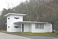
Bear Creek Road Checking Station
This old checking station is found at the junction of South Illinois Avenue and Bear Creek Road in Oak Ridge. During its early days, Oak Ridge was a secret city, and these stations were used to control who could enter and leave.
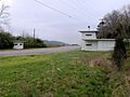
Bethel Valley Road Checking Station
Similar to the Bear Creek station, this one is at the junction of Bethel Valley and Scarboro Roads. These stations are important reminders of Oak Ridge's past as a highly restricted area.
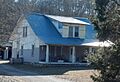
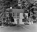
Luther Brannon House
You can find the Luther Brannon House at 151 Oak Ridge Turnpike. This house is a historic building in Oak Ridge, showing some of the older architecture in the area before the city grew so rapidly.
Freels Cabin
The Freels Cabin, also known as "Freels Bend Cabin," was built in 1844. It's located on Freels Bend Road in Oak Ridge. This cabin is one of the oldest structures in the area and gives us a peek into life before Oak Ridge became a city. It's currently on federal property that is not open to the public.
J. B. Jones House
The J. B. Jones House is located on Old Edgemoor Road, between Bethel Valley Road and Melton Hill Lake. This house is another example of the early homes in the Oak Ridge area.
Oak Ridge Historic District
This large historic district in Oak Ridge includes many important buildings and areas. It's roughly bounded by East Drive, West Outer Drive, Louisiana Avenue, and Tennessee Avenue. Some of the notable places within this district include the United Church, The Chapel on the Hill, the Alexander Inn, and the building that now houses the Children's Museum of Oak Ridge. This district helps preserve the unique design and history of the secret city.
Woodland-Scarboro Historic District
Another historic district in Oak Ridge, this area is roughly bounded by Rutgers Avenue, Lafayette Drive, Benedict Avenue, Wilberforce Avenue, and Illinois Avenue. It represents another important part of Oak Ridge's development and history.
Clinton's Downtown Gems
The city of Clinton also has several buildings that are recognized for their historical importance.
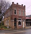
Daugherty Furniture Building
Located at 307 North Main Street in Clinton, this building is a historic part of the downtown area. It shows the kind of businesses and architecture that were common in Clinton's past.
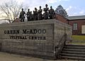
Green McAdoo School
The Green McAdoo School, found at 101 School Street in Clinton, is a very important site for civil rights history. It played a key role during the desegregation of schools in the 1950s.
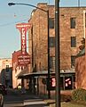
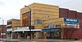
Ritz Theatre and Hoskins Rexall Drug Store No. 2
These two buildings, located at 111-121 North Main Street in Clinton, are listed together. The Ritz Theatre was a popular movie theater, and Hoskins Rexall Drug Store was a well-known local business that started in 1930. The Main Street location opened in 1947, and at one time, there were many Hoskins stores across East Tennessee.
Briceville and Rocky Top's Mining History
The areas around Briceville and Rocky Top have a rich history tied to coal mining and the challenges faced by miners.
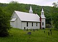
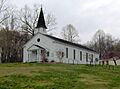
Briceville Community Church and Cemetery
This church, located on State Route 116 in Briceville, is a beautiful example of rural Gothic Revival architecture. While it's a church, it also serves as a community center, bringing people together.
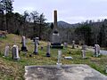
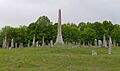
Cross Mountain Miners' Circle
Found on Circle Cemetery Lane in Briceville, this site is a memorial to miners who died in the Cross Mountain Mine disaster. It's a place to remember the brave people who worked in the mines.
Edwards-Fowler House
This historic house is located about 3½ miles south of Rocky Top on Dutch Valley Road. It's an old home that tells a story about the early settlers and families in the area.
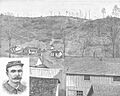
Fort Anderson on Militia Hill
Located on Vowell Mountain Road in Rocky Top, this site was a military garrison during the Coal Creek War in the early 1890s. This was a time when local coal miners and the state government had disagreements over the use of different types of labor in the coal mines.
Fraterville Miners' Circle Cemetery
This cemetery, on Leach Cemetery Lane in Rocky Top, is another important memorial site. It honors the miners who lost their lives in the tragic Fraterville Mine disaster.
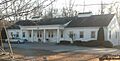
Oliver Springs Banking Company
The Oliver Springs Banking Company building is located at 110 East Tri County Boulevard in Oliver Springs. This historic building shows the economic development and banking history of the town.
Images for kids
-
The Arnwine Cabin, part of the Museum of Appalachia
-
The Bear Creek Road Checking Station in Oak Ridge
-
The Bethel Valley Road Checking Station
-
The Luther Brannon House
-
Briceville Community Church
-
The Cross Mountain Miners' Circle
-
The Daugherty Furniture Building in Clinton
-
Fort Anderson on Militia Hill
-
The Fraterville Miners' Circle Cemetery
-
The J. B. Jones House
-
The Green McAdoo School
-
Rustic cabins at Norris Dam State Park
-
A historic house in the Norris District
-
Norris Dam
-
The United Church, Chapel on the Hill, in the Oak Ridge Historic District
-
The Oliver Springs Banking Company building
-
The Ritz Theatre and Hoskins Rexall Drug Store in Clinton
-
A building in the Woodland-Scarboro Historic District


.jpg)


