
National Register of Historic Places listings in Ascension Parish, Louisiana facts for kids

Welcome to Ascension Parish, Louisiana! This area is home to many amazing places that are so important to history, they've been added to a special list called the National Register of Historic Places. Think of it like a Hall of Fame for buildings, sites, and districts that tell us about America's past.
When a place is on this list, it means it's recognized for its historical, architectural, or archaeological importance. It helps protect these sites so future generations can learn from them. In Ascension Parish, there are 17 places currently on this list. A few others were once listed but have since been removed, perhaps because they were changed or no longer existed.
Contents
Exploring Historic Places in Ascension Parish
Ascension Parish is full of history, especially from the time when large plantations were common. Many of the places on the National Register are beautiful old homes and buildings that show us what life was like long ago.
Grand Plantations and Homes
Many of the most famous historic places in Ascension Parish are old plantations. These were large farms, often growing sugar cane, with grand houses and other buildings.
Ashland Plantation (Belle Helene)
Ashland Plantation, also known as Belle Helene, is a stunning old home located south of Geismar. It was built a long time ago and is a great example of the beautiful architecture from that period. It was officially added to the National Register in 1979.
Bocage Plantation
Bocage Plantation is another impressive historic home near Darrow. It's known for its unique design and has been a part of the National Register since 1991.
The Houmas
The Houmas is a very large and grand mansion built in 1840. It's a great example of the Greek Revival style of architecture, which was popular at the time. It sits next to an even older house and has other interesting buildings around it. This historic site was added to the list in 1980.
Hermitage Plantation
Hermitage, located east of Darrow, was built in 1812. It was originally named L'Hermitage in French, inspired by Andrew Jackson's famous home in Tennessee. It's said that General and Mrs. Jackson even visited this very spot in the 1820s! It became a protected historic place in 1973.
Important Buildings and Districts
Beyond the grand homes, other types of places are also important to history. These can be entire neighborhoods or special buildings that tell a story.
Donaldsonville Historic District
The Donaldsonville Historic District is not just one building, but a whole area in Donaldsonville that is historically significant. It includes many streets and buildings that show what the town looked like in the past. This district was recognized in 1984.
Landry Tomb
In the Ascension Catholic Church Cemetery in Donaldsonville, you'll find the Landry Tomb. This family monument was built around 1845 and is believed to have been designed by a famous architect named James H. Dakin. It was added to the National Register in 1982.
Lemann Store
The Lemann Store, located on Mississippi Street in Donaldsonville, is another historic building. It was listed in 1982, showing its importance to the town's history and development.
Sites of Historical Significance
Some places are important not just for their buildings, but for the events that happened there.
Evan Hall Slave Cabins
West of Donaldsonville are the Evan Hall Slave Cabins. These cabins are a very important reminder of the history of slavery in Louisiana. They help us understand the lives of enslaved people who worked on plantations. This site was added to the National Register in 1983.
Fort Butler
Fort Butler in Donaldsonville is a significant site from the American Civil War. A monument there marks the spot where a battle was fought on June 28, 1863. This fort played a role in the history of the war and was listed in 1999.
Other Notable Listings
Many other properties in Ascension Parish are also recognized for their historical value. These include:
- Dixon House in Prairieville (1999)
- Helvetia Dependency in Darrow (1992)
- Mulberry Grove near White Castle (1993)
- Palo Alto Dependency in Donaldsonville (1992)
- Palo Alto Plantation in Donaldsonville (1977)
- Rome House in Smoke Bend (1990)
- St. Emma Plantation south of Donaldsonville (1980)
- Tezcuco near Burnside (1983) - Sadly, this historic home was completely destroyed by fire in 2002.
- Robert Penn Warren House in Prairieville (1993) - Also known as Twin Oaks, this was the home of a famous writer.
Current Listings in Detail
Here is a complete list of the properties and districts currently on the National Register of Historic Places in Ascension Parish, Louisiana.
| Name on the Register | Image | Date listed | Location | City or town | Description | |
|---|---|---|---|---|---|---|
| 1 | Ashland |
.jpg) |
(#79001050) |
2 miles (3.2 km) south of Geismar on Louisiana Highway 75 30°10′34″N 90°59′56″W / 30.176111°N 90.998889°W |
Geismar | Also known as Belle Helene |
| 2 | Bocage |
 |
(#91000705) |
Louisiana Highway 942 south of Marchandville 30°07′24″N 90°57′19″W / 30.123333°N 90.955278°W |
Darrow | |
| 3 | Dixon House |
 |
(#99000634) |
38127 Louisiana Highway 42 30°19′11″N 90°58′17″W / 30.319722°N 90.971389°W |
Prairieville | |
| 4 | Donaldsonville Historic District |
 |
(#84001248) |
Roughly bounded by Bayou LaFourche, the Mississippi River levee, Jackson Ave., Marchand Dr., and Monroe and Church Sts. 30°06′09″N 90°59′15″W / 30.1025°N 90.9875°W |
Donaldsonville | |
| 5 | Evan Hall Slave Cabins |
 |
(#83000484) |
West of Donaldsonville 30°07′05″N 91°02′40″W / 30.118056°N 91.044444°W |
Donaldsonville | |
| 6 | Fort Butler |
 |
(#99000183) |
Address Restricted |
Donaldsonville | Monument marks the location of a Civil War battle fought on the 28th of June 1863. |
| 7 | Helvetia Dependency |
(#92000570) |
Louisiana Highway 942 30°07′02″N 90°57′44″W / 30.117222°N 90.962222°W |
Darrow | ||
| 8 | Hermitage |
(#73000859) |
1.75 miles east of Darrow on Louisiana Highway 942 30°06′55″N 90°57′45″W / 30.115278°N 90.9625°W |
Darrow | Built in 1812, originally L'Hermitage in French – named after Andrew Jackson's Tennessee home The Hermitage. General & Mrs. Jackson reportedly visited here during an 1820s trip to New Orleans. | |
| 9 | The Houmas |
 |
(#80001694) |
West of Burnside off Louisiana Highways 22 and 44 30°08′19″N 90°56′00″W / 30.138611°N 90.933333°W |
Burnside | Large Greek Revival mansion built in 1840, adjacent to an earlier Federal-style house and several other ancillary structures including octagonal garconnieres |
| 10 | Landry Tomb |
 |
(#82002752) |
Ascension Catholic Church Cemetery, St. Vincent and Claiborne Sts. 30°05′57″N 90°59′09″W / 30.099167°N 90.985833°W |
Donaldsonville | Circa-1845 family monument attributed to architect James H. Dakin |
| 11 | Lemann Store |
 |
(#82002753) |
314 Mississippi St. 30°06′22″N 90°59′14″W / 30.106111°N 90.987222°W |
Donaldsonville | |
| 12 | Mulberry Grove |
 |
(#93001118) |
Louisiana Highway 405, 7 miles east-northeast of its junction with Louisiana Highway 1 30°11′34″N 91°02′10″W / 30.192778°N 91.036111°W |
White Castle | |
| 13 | Palo Alto Dependency |
 |
(#92000579) |
Louisiana Highway 944 30°05′28″N 91°01′57″W / 30.091111°N 91.0325°W |
Donaldsonville | |
| 14 | Palo Alto Plantation |
 |
(#77000665) |
West of Donaldsonville on Louisiana Highway 1 30°05′28″N 91°01′52″W / 30.091111°N 91.031111°W |
Donaldsonville | |
| 15 | Rome House |
 |
(#90000323) |
Louisiana Highway 1 at Delany Ln. 30°06′30″N 91°01′11″W / 30.108333°N 91.019722°W |
Smoke Bend | |
| 16 | St. Emma |
 |
(#80001695) |
South of Donaldsonville 30°05′02″N 91°01′50″W / 30.083889°N 91.030556°W |
Donaldsonville | |
| 17 | Tezcuco |
 |
(#83000485) |
South of Burnside on River Rd. 30°06′57″N 90°54′38″W / 30.115833°N 90.910556°W |
Burnside | Completely destroyed by fire in May 2002 |
| 18 | Robert Penn Warren House |
 |
(#92001732) |
16381 Old Jefferson Highway 30°18′29″N 90°58′25″W / 30.308056°N 90.973611°W |
Prairieville | Also known as Twin Oaks |
Former Listings
Sometimes, places are removed from the National Register. This can happen if they are destroyed, heavily changed, or no longer meet the requirements. Here are some places that were once listed in Ascension Parish:
| Name on the Register | Image | Date listed | Date removed | Location | City or town | Summary | |
|---|---|---|---|---|---|---|---|
| 1 | Kraemer House |
(#84001250) |
|
Off U.S. Route 61 30°17′53″N 90°57′44″W / 30.298056°N 90.962222°W |
Prairieville | ||
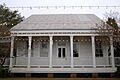
| 2 | St. Joseph's School |
 |
(#88002651) |
|
Louisiana Highways 22 and 44 30°08′59″N 90°55′23″W / 30.149722°N 90.923056°W |
Burnside |
Images for kids
-
St. Joseph's School, a former listing.
