
National Register of Historic Places listings in Beaverhead County, Montana facts for kids

This page tells you about some really cool and important places in Beaverhead County, Montana. These places are so special that they are listed on the National Register of Historic Places. This is like a special list of buildings, areas, and sites across the United States that are important to history.
There are 23 places in Beaverhead County on this list. Two of them are even more important and are called National Historic Landmarks! You can find these places on a map if you look up their exact locations.
Historic Places in Beaverhead County
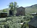
Bannack Historic District

Imagine stepping back in time to a real ghost town! That's what you'll find at the Bannack Historic District. This was Montana's very first capital city. It was founded in 1862 after gold was discovered nearby. Today, you can explore many of the original buildings, which are kept safe and sound. It's like a living museum where you can see what life was like for pioneers and gold miners. Bannack is about 22 miles from Dillon.
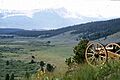
Big Hole National Battlefield

The Big Hole National Battlefield is a very important historical site. It's located about 12 miles west of Wisdom. This battlefield marks a sad but important event in American history. In 1877, a battle took place here during the Nez Perce War. The Nez Perce people were trying to escape to Canada when they were attacked by the U.S. Army. Today, it's a place to learn about this conflict and remember what happened.
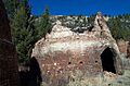
Canyon Creek Charcoal Kilns

Have you ever seen a charcoal kiln? The Canyon Creek Charcoal Kilns are unique, beehive-shaped structures. They are about 5 miles northwest of Glendale. These kilns were built in the late 1800s. They were used to make charcoal from wood. This charcoal was then used to fuel smelters, which melted down metal ores from nearby mines. It's a cool example of early industrial history in Montana.
Clark's Lookout, August 13, 1805
_-_Beaverhead_County,_Montana.png)
Clark's Lookout is a special spot near Dillon. It's named after William Clark, one of the leaders of the famous Lewis and Clark Expedition. On August 13, 1805, Clark climbed to this spot to look for the Beaverhead River. He was trying to find the best way for the expedition to continue their journey. It's a place where you can imagine what it was like for explorers to see new lands for the first time.
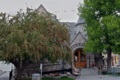
Dillon City Library
_-_Beaverhead_County,_Montana.png)
The Dillon City Library is a beautiful old building in the heart of Dillon. It was built in 1902 and has been serving the community ever since. Libraries are important places for learning and connecting with others. This building is a great example of the architecture from that time period.
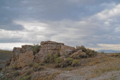
Elkhorn-Coolidge Historic District

The Elkhorn-Coolidge Historic District tells the story of Montana's mining past. It includes the old Elkhorn mine site and the nearby ghost town of Coolidge. This area was once a busy place where people worked to extract valuable minerals from the earth. Now, it's a quiet reminder of the mining boom that shaped much of Montana's history. It's located near Wise River.
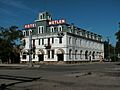
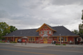
Hotel Metlen

The Hotel Metlen is a grand old hotel in Dillon. It was built in 1897 and has been a central part of the town for over a century. Imagine all the travelers and important people who have stayed there over the years! It's a great example of the kind of fancy hotels that were built during that time.
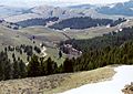
Lemhi Pass

Lemhi Pass is a very important historical location. It's west of Grant and sits in the Beaverhead National Forest. This pass is where the Lewis and Clark Expedition crossed the Continental Divide in 1805. This means they crossed from rivers that flow to the Atlantic Ocean to rivers that flow to the Pacific Ocean. It's also where Sacagawea, their Native American guide, recognized the area as her homeland. It's a place of great natural beauty and historical significance.
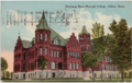
Montana State Normal School

The Montana State Normal School is an important part of education history in Montana. Located in Dillon, this school was founded in 1893. A "normal school" was a place where teachers were trained. Many of the teachers who taught in Montana's early schools got their education here. Today, it's known as the University of Montana Western.
Oregon Short Line Passenger Depot
_-_Beaverhead_County,_Montana.png)
The Oregon Short Line Passenger Depot is the old train station in Dillon. Built in 1909, this building was once a very busy place. Trains were a main way for people to travel and for goods to be moved across the country. This depot saw countless passengers come and go, connecting Dillon to the wider world. It's a reminder of the important role railroads played in developing Montana.
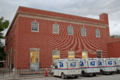
US Post Office-Dillon Main
_-_Beaverhead_County,_Montana.png)
The US Post Office-Dillon Main is another historic building in Dillon. Built in 1934, this post office has served the community for many years. Post offices are important for sending letters and packages, connecting people far and wide. This building is a good example of the style of public buildings constructed during the Great Depression era.
Images for kids
-
The old town of Bannack, Montana.
-
A view of the Big Hole National Battlefield.
-
The unique charcoal kilns at Canyon Creek.
-
The view from Clark's Lookout.
-
The historic Dillon City Library building.
-
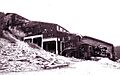
The Elkhorn Mine and Mill in 1917.
-
The historic Hotel Metlen in Dillon.
-
A sign marking Lemhi Pass.
-
The Main Hall of the Montana State Normal School.
-
The old Oregon Short Line Passenger Depot.
-
The historic US Post Office in Dillon.
