
National Register of Historic Places listings in Blaine County, Idaho facts for kids

Have you ever wondered about the old buildings, bridges, or special places in your town or county? Many of these places are important because they tell us stories about the past. In Blaine County, Idaho, there are many such places that are so special, they've been added to a list called the National Register of Historic Places.
This list is like a hall of fame for historic sites across the United States. When a place is on this list, it means it's recognized as important for its history, architecture, or what it means to the community. It also helps protect these places for future generations. In Blaine County, there are 23 different buildings, areas, and structures that have earned a spot on this important list. Let's explore some of them!
Contents
Historic Gems in Blaine County
These places are protected because they help us remember and understand the history of Blaine County. Each one has a unique story!
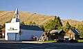
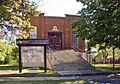
Bellevue's Historic District
The Bellevue Historic District is a special area in Bellevue. It includes many old buildings that show what the town looked like long ago. Walking through this district is like taking a step back in time! It was added to the list in 1982.
Hailey's Important Buildings
The city of Hailey has many historic buildings.
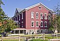
Blaine County Courthouse
The Blaine County Courthouse is a very important building in Hailey. It's where many local government decisions are made. It was built a long time ago and was added to the National Register in 1978.
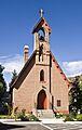
Emmanuel Episcopal Church
The Emmanuel Episcopal Church is another historic building in Hailey. It's a beautiful church that has been a part of the community for many years. It joined the list in 1977.
J. C. Fox Building
The J. C. Fox Building on S. Main Street in Hailey is an old business building. It reminds us of the shops and businesses that used to be central to the town. It was listed in 1983.
Hailey Masonic Lodge
The Hailey Masonic Lodge is a building where a local group called the Masons used to meet. These lodges often have interesting architecture. This one was added to the list in 2008.
Hailey Methodist Episcopal Church
The Hailey Methodist Episcopal Church is another historic church in Hailey. It has served the community for many years and was recognized in 2017.
The Rialto Hotel
The Rialto Hotel in Hailey is an old hotel that once welcomed travelers and visitors. Historic hotels often have grand designs and stories from the past. It was added to the list in 2009.
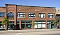
W. H. Watt Building
The W. H. Watt Building is another historic commercial building in Hailey. It shows us what downtown Hailey looked like in earlier times. It was listed in 1983.
Werthheimer Building
The Werthheimer Building, also in Hailey, is another example of the historic architecture found in the town's center. It joined the list in 1985.
Ketchum's Unique Sites
Ketchum also has several places on the National Register.
Bald Mountain Hot Springs
The Bald Mountain Hot Springs are natural hot springs near Ketchum. People have enjoyed these warm waters for a very long time. They were listed in 1982.
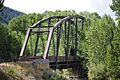
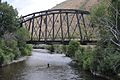
Cold Springs Pegram Truss Railroad Bridge
The Cold Springs Pegram Truss Railroad Bridge is a special kind of bridge that crosses the Big Wood River. It's an old railroad bridge with a unique design, important for understanding how trains used to travel through the area. It was added to the list in 1997.
Gimlet Pegram Truss Railroad Bridge
Similar to the Cold Springs bridge, the Gimlet Pegram Truss Railroad Bridge also crosses the Big Wood River and has the same special design. These bridges are important examples of engineering from the past. It was listed in 1997.
Greenhow and Rumsey Store Building
The Greenhow and Rumsey Store Building in Ketchum is an old store. It gives us a glimpse into what shopping and business were like in Ketchum long ago. It was added to the list in 1983.
Ketchum Ranger District Administrative Site
The Ketchum Ranger District Administrative Site is a collection of buildings that were used by forest rangers. These sites are important for understanding the history of managing our national forests. It joined the list in 2007.
Ernest and Mary Hemingway House
The Ernest and Mary Hemingway House is the home of famous writer Ernest Hemingway and his wife Mary. Hemingway was a very important American author, and his home is a significant part of literary history. It was added to the list in 2015.
Other Notable Places in Blaine County
Fish Creek Dam
The Fish Creek Dam, located northeast of Carey, is an old dam that helped manage water resources in the area. Dams are important structures that help with farming and providing water. It was listed in 1978.
Henry Miller House
The Henry Miller House, south of Bellevue, is a historic home. Old houses often have unique architectural styles and stories about the families who lived there. It was added to the list in 1975.
Proctor Mountain Ski Lift
The Proctor Mountain Ski Lift in Sun Valley is a historic ski lift. Sun Valley is famous for its skiing, and this lift is a piece of that history, showing how skiing developed in the area. It was listed in 1980.
Sawtooth City
Sawtooth City is a historic area southeast of Alturas Lake, near Sun Valley. It's a reminder of old mining towns or settlements that once thrived in the region. It was added to the list in 1975.
Former Listings
Sometimes, a place might be removed from the National Register if it no longer exists or has lost its historic features.
Hiawatha Hotel
The Hiawatha Hotel in Hailey was once on the list, but it was removed in 1986 because it unfortunately burned down in 1979.
Images for kids
-
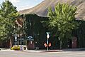
The historic Old City Hall in Bellevue.
-
The Blaine County Courthouse in Hailey.
-
The Cold Springs Pegram Truss Railroad Bridge.
-
Emmanuel Episcopal Church in Hailey.
-
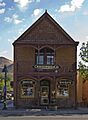
The J. C. Fox Building in Hailey.
-
The Gimlet Pegram Truss Railroad Bridge.
-
The Hailey Masonic Lodge.
-
The Ketchum Ranger District Administrative Site.
-
The Rialto Hotel in Hailey.
-
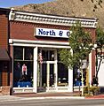
The W. H. Watt Building in Hailey.
-
The Werthheimer Building in Hailey.


