
National Register of Historic Places listings in Blaine County, Montana facts for kids

Blaine County, Montana, is a place filled with history! Many important buildings and areas in the county are listed on the National Register of Historic Places. This special list helps protect places that are important to American history, architecture, archaeology, engineering, or culture. When a place is on this list, it means it's recognized as a valuable part of our past.
In Blaine County, there are 10 different places that have been added to the National Register. These places tell stories about battles, early settlers, and the daily lives of people who lived here long ago. Let's explore some of these amazing historic sites!
Contents
Historic Places in Blaine County
Chief Joseph Battleground of the Bear's Paw

One of the most famous historic sites in Blaine County is the Chief Joseph Battleground of the Bear's Paw. This place is about 15 miles south of Chinook. It's where a very important battle happened in 1877.
This battle was the last major fight of the Nez Perce War. The Nez Perce people, led by their brave chief, Chief Joseph, were trying to escape to Canada to find safety. They had traveled over 1,000 miles, but the U.S. Army caught up to them here. The battle was a sad and difficult time, marking the end of the Nez Perce's long journey for freedom. Today, the battleground is a National Historic Landmark, which means it's one of the most important historic sites in the entire country.
Cow Island Landing Skirmish Site

Near Winifred, you can find the Cow Island Landing Skirmish Site. This spot is along the Missouri River and was important during the Nez Perce War, just like the Bear's Paw Battleground.
Cow Island Landing was a place where steamboats would drop off supplies. In 1877, as the Nez Perce were trying to escape, they had a small fight with U.S. soldiers here. It was a skirmish, meaning a quick and short battle, as the Nez Perce tried to get past the soldiers to continue their journey. This site helps us remember the challenges and conflicts of that time.
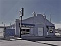
Dave's Texaco
_-_Blaine_County,_Montana.png)
In the town of Chinook, there's a historic building called Dave's Texaco. It's located at 237 Pennsylvania Street. This building was added to the National Register in 1994.
Dave's Texaco is a great example of an old gas station and garage. These types of buildings were very common when cars first became popular. They show us what everyday life was like in the past and how people traveled and took care of their vehicles. It's a piece of local history that reminds us of the early days of driving.
Ervin Homestead-Gist Bottom Historic District

The Ervin Homestead-Gist Bottom Historic District is located near Hays, along the Missouri River. This area was added to the National Register in 2016.
A homestead is a piece of land given by the government to settlers who promised to live on and farm it. The Ervin Homestead is an example of an early ranch that was started beside the Missouri River in a beautiful area known as the Upper Missouri River Breaks National Monument. It shows us how early settlers lived and worked the land in Montana.
Lohman Block

Another historic building in Chinook is the Lohman Block, found at 239-225 Indiana Street. It was listed on the National Register in 1980.
The Lohman Block is an important building because it represents the early growth of Chinook as a town. Often, "blocks" like this were built to house several businesses or offices. They show the kind of architecture and business activity that was happening in Montana towns many years ago.
Young Brothers Chevrolet Garage

Also in Chinook, at 201 Pennsylvania Street, is the Young Brothers Chevrolet Garage. This building was added to the National Register in 1994, the same year as Dave's Texaco.
Like Dave's Texaco, this garage is a reminder of the early days of cars and how important they became to people's lives. It shows the kind of places where people bought and repaired their cars, and it's a part of the town's business history.
Images for kids
-
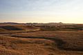
A view of the Chief Joseph Battleground of the Bear's Paw.
-
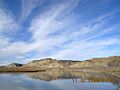
The historic Cow Island Landing area.
-

Dave's Texaco building in Chinook.
-
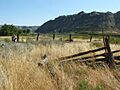
A corral at the Ervin Homestead-Gist Bottom Historic District.
-

The Lohman Block building in Chinook.
-
The Young Brothers Chevrolet Garage in Chinook.
