
National Register of Historic Places listings in Bracken County, Kentucky facts for kids

Welcome to Bracken County, Kentucky! This page is all about special places here that are listed on the National Register of Historic Places. Think of this register as a super important list of buildings, areas, and sites across the United States that are worth protecting because of their history or unique design.
In Bracken County, there are 23 amazing spots on this list. Each one has a story to tell about the past! You can even see where some of these places are on a map if you look at their coordinates. Let's explore some of these cool historic sites!
Contents
- Historic Gems in Bracken County
- Augusta's Historic Buildings and Districts
- Augusta College Historic Buildings
- Augusta Historic District
- Baker Vineyard and Wine Cellar
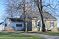
- George W. Barkley Farm
- Brothers-O'Neil House
- Mordecai Chalfant House
- Confederate Monument in Augusta
- Evan Griffith's Grocery
- Alfonso McKibben House
- J. R. Minor House
- Stone House on Bracken Creek
- Stroube House
- Turtle Creek Site (15BK13)
- Water Street Historic District
- James Weldon House
- Wells-Keith House
- Historic Sites Beyond Augusta
- Augusta's Historic Buildings and Districts
- Images for kids
Historic Gems in Bracken County
Augusta's Historic Buildings and Districts
Augusta is a town in Bracken County with many historic treasures.
Augusta College Historic Buildings
The old buildings of Augusta College are found at 205 Frankfort Street and 204 Bracken Street. These buildings were added to the list on February 20, 1980. They remind us of a time when education was growing in the area.

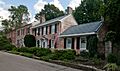
Augusta Historic District
A whole area of Augusta, called the Augusta Historic District, is on the list! This district includes streets like Riverside Drive, 5th Street, Frankfort Street, and Williams Street. It was recognized on March 13, 1984, because it keeps the old charm and look of the town.

Baker Vineyard and Wine Cellar
Just south of Augusta, you'll find the Baker Vineyard and Wine Cellar. This special place, located near Kentucky Route 1839 and 4465 West Augusta-Chatham Road, was added to the register on December 30, 1974. It's a reminder of early winemaking in Kentucky.

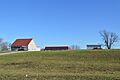
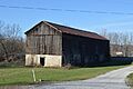
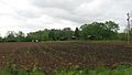
George W. Barkley Farm
The George W. Barkley Farm, located along Kentucky Route 8, became a historic site on June 18, 2003. This farm shows us how people lived and farmed in the past.

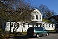
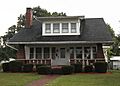
Brothers-O'Neil House
The Brothers-O'Neil House at 308 Seminary Road in Augusta was listed on May 22, 1984. It's a beautiful example of older homes in the area.

Mordecai Chalfant House
Another interesting home, the Mordecai Chalfant House, is on Kentucky Route 8 near Augusta. It joined the list on January 8, 1987.

Confederate Monument in Augusta
In Payne Cemetery, north of Kentucky Route 8, stands the Confederate Monument. This monument was added to the register on July 17, 1997. It's a historical marker from the time of the American Civil War.

Evan Griffith's Grocery
The old Evan Griffith's Grocery at 415 Railroad Avenue in Augusta was listed on May 22, 1984. It tells a story about local businesses from long ago.

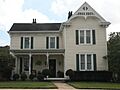
Alfonso McKibben House
The Alfonso McKibben House at 202 4th Street in Augusta was added to the list on May 22, 1984. It's another example of the historic homes in Augusta.

J. R. Minor House
At 204 2nd Street in Augusta, you'll find the J. R. Minor House. This house was recognized on May 22, 1984.

Stone House on Bracken Creek
The Stone House on Bracken Creek, located off Kentucky Route 435 near Augusta, was listed on January 8, 1987. Stone houses are often very old and built to last!
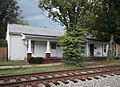
Stroube House
The Stroube House on Kentucky Route 616 near Augusta joined the register on January 8, 1987.

Turtle Creek Site (15BK13)
The Turtle Creek Site is an important archaeological spot along the Ohio River bank, west of Augusta. It was listed on November 14, 1985, and helps us learn about ancient cultures.
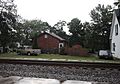
Water Street Historic District
Another historic area in Augusta is the Water Street Historic District. It runs from River Side Drive east to Frankfort Street and west to Ferry Street. This district was listed on September 24, 1975, showing the importance of the riverfront in Augusta's history.

James Weldon House
The James Weldon House at 417 Railroad Street in Augusta was added to the list on May 22, 1984.

Wells-Keith House
Finally, the Wells-Keith House at 411-413 3rd Street in Augusta was also listed on May 22, 1984.

Historic Sites Beyond Augusta
Bracken County has other important places outside of Augusta too!
Bold House
The Bold House at 98 Main Street in Foster, Kentucky, was added to the register on March 13, 2017. It's a more recent addition to the list of historic places.
Bracken County Infirmary
Northeast of Chatham, on Kentucky Route 19, you'll find the site of the Bracken County Infirmary. It was listed on April 16, 1979. An infirmary was a place where people who were sick or elderly could get care.

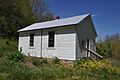
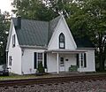
Bradford School House
The Bradford School House is located at the intersection of Kentucky Routes 8 and 1109 in Foster. This old schoolhouse was recognized on June 18, 2003, reminding us of how education used to be.

John Gregg Fee House
Northwest of Germantown, the John Gregg Fee House was listed on August 26, 1980. John Gregg Fee was an important person in Kentucky's history, known for his work against slavery and for education.
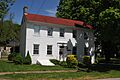
Rock Spring Warehouse
The Rock Spring Warehouse on Kentucky Route 8 in Wellsburg was added to the register on January 8, 1987. Warehouses like this were important for storing goods and trade.

Snag Creek Site (15BK2)
The Snag Creek Site (also known as 15BK2) is an archaeological site on the western side of Snag Creek, south of the Ohio River near Willow Grove. It was listed on November 14, 1985. This site helps experts learn about ancient people who lived in this area long ago.

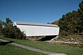
Walcott Covered Bridge
About 3.5 miles north of Brooksville, on Kentucky Route 1159, you can find the Walcott Covered Bridge over Locust Creek. This beautiful bridge was listed on June 10, 1975. Covered bridges are a special part of American history and are often very old!

Images for kids
-

Location of Bracken County in Kentucky
-
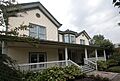
Echo Hall in Augusta
-
Augusta Historic District
-
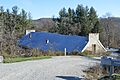
Baker Wine Cellar
-
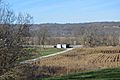
George W. Barkley Farm fields
-
Bracken County Infirmary site
-
Bradford School House
-
Brothers-O'Neil House
-

Mordecai Chalfant House through the trees
-

Confederate Monument in Augusta
-
Evan Griffith's Grocery
-
Alfonso McKibben House
-
J. R. Minor House
-
Rock Spring Warehouse from southeast
-
Snag Creek Site
-
Stroube House from northwest
-
Walcott Covered Bridge
-
Water Street Historic District
-
James Weldon House
-
Wells-Keith House
