
National Register of Historic Places listings in Calloway County, Kentucky facts for kids

Have you ever wondered about the oldest or most special buildings and places in your town? In Calloway County, Kentucky, there's a list of these important spots! It's called the National Register of Historic Places. This list helps protect buildings, sites, and objects that are important to American history, architecture, archeology, engineering, or culture.
When a place is on this list, it means it's recognized as a valuable part of our past. It also helps make sure these places are kept safe for future generations to learn from and enjoy. Calloway County has 17 different places on this special list. Let's explore some of them!
Contents
Historic Places in Calloway County
Important Buildings and Sites
Many buildings in Calloway County have a rich history. They tell us about how people lived, worked, and worshipped long ago.
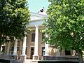
Calloway County Courthouse
The Calloway County Courthouse is right in the middle of Murray, Kentucky. It's a very important building where local government decisions are made. It was added to the National Register in 1986.
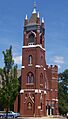
First Baptist Church
The First Baptist Church is located on South 4th Street in Murray. Churches are often central to a community's history, and this one was recognized in 1986.
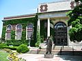
First Christian Church
Another historic church in Murray is the First Christian Church on North 5th Street. It also joined the National Register in 1986.
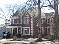
Edwin S. Diuguid House
The Edwin S. Diuguid House is a historic home on West Main Street in Murray. It was added to the list in 1976, showing its importance to the area's past.
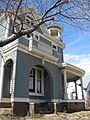
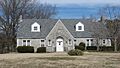
Will Linn House
The Will Linn House is another old home in Murray, found on North 6th Street. It became a historic place in 1980.
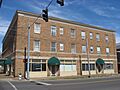
National Hotel
The National Hotel stands at North 6th and Main Streets in Murray. Hotels often played a big role in travel and community life in the past. This one was listed in 1986.
U.S. Post Office
The U.S. Post Office in Murray, located at Maple and South 4th Street, is also on the list. Post offices were vital for communication and connecting communities. It was added in 1986.
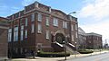
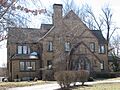
Murray Woman's Club Clubhouse
The Murray Woman's Club Clubhouse on Vine Street in Murray is a special place. Women's clubs often worked to improve their communities, and this clubhouse was recognized in 2011.
W.G. Swann Tobacco Company
The W.G. Swann Tobacco Company building on Poplar Street in Murray tells us about the area's economic history. It was added to the National Register in 2015.
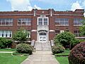
Old Normal School Building
The Old Normal School Building is on the Murray State University campus. Normal schools were places where teachers were trained. This building is a key part of the university's history and was listed in 1975.
Seclusaval
Seclusaval is a historic site located east of Murray on KY 614. It was recognized in 1975.
Historic Districts
Sometimes, it's not just one building that's important, but a whole group of buildings or an area. These are called historic districts.
Main Street Historic District
The Main Street Historic District includes blocks of West Main Street in Murray. This area shows what the town looked like in earlier times and was listed in 1986.
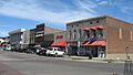
Murray Commercial Historic District
The Murray Commercial Historic District covers a larger area in downtown Murray, including parts of Walnut, L.P. Miller, Poplar, and 6th Streets. This district shows how businesses and shops developed in Murray. It was added in 2003.
Murray State University Historic Buildings
The Murray State University Historic Buildings district includes several important buildings on the university campus. This shows the growth and history of the university itself. It was first listed in 1978, with an addition in 1983.
Ancient and Military Sites
Calloway County also has sites that tell us about even older times or important historical events.
Backusburg Mounds
The Backusburg Mounds, also known as Archeological Site 15CW64, are located near Backusburg along the Clarks River. These mounds are ancient sites that give us clues about early people who lived in this area. They were added to the list in 1985.
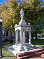
Confederate Monument in Murray
The Confederate Monument in Murray is found at the junction of KY 94 and KY 121. Monuments like this help us remember important historical events, in this case, the American Civil War. It was listed in 1997.
Fort Heiman Site
The Fort Heiman Site is near New Concord. This site is part of a larger battlefield from the Civil War. It was recognized in 1976.
Images for kids
-
Calloway County Courthouse
-
Confederate Monument in Murray
-
Edwin S. Diuguid House
-
First Baptist Church
-
First Christian Church
-
Will Linn House
-
Main Street Historic District
-
Murray Commercial Historic District
-
Murray State University Historic Buildings
-
The Murray Woman's Club Clubhouse
-
National Hotel
-
Old Normal School Building
-
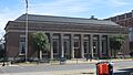
US Post Office-Murray


