
National Register of Historic Places listings in Cedar County, Nebraska facts for kids
This article is about special places in Cedar County, Nebraska that are important to history. These places are listed on the National Register of Historic Places. It's like a special list of buildings, areas, and sites that the United States government thinks are worth protecting because they tell us about the past.
You can find 14 different places and areas from Cedar County on this list. One place was on the list before, but it has since been removed. If you look at a map, you can often see where these special places are located.

Contents
- Cool Places You Can Still See
- Cedar County Courthouse
- Hartington City Hall and Auditorium
- Couser Barn
- Hartington Hotel
- Immaculate Conception Catholic Church and Rectory
- Meridian Bridge
- St. Boniface Catholic Church Complex
- Saints Peter and Paul Catholic Church Complex
- Saints Philip and James Parochial School
- Schulte Archeological Site
- Wiseman Archeological Site
- Franz Zavadil Farmstead
- Places That Were Once Listed
- Images for kids
Cool Places You Can Still See
Here are some of the interesting places in Cedar County that are currently on the National Register of Historic Places:
Cedar County Courthouse
The Cedar County Courthouse is a big, important building in Hartington, Nebraska. It's located on Broadway Avenue. This courthouse was added to the list in 1990. It's where many important decisions for the county are made.
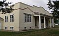
Hartington City Hall and Auditorium
Also in Hartington, Nebraska, the City Hall and Auditorium is a cool building at 101 North Broadway. It was built in a style called Prairie School, designed by an architect named William L. Steele. This building is used for many different things in the city and was listed in 1983.
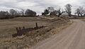
Couser Barn
The Couser Barn is a historic barn near Laurel, Nebraska. It was added to the list in 1986. The exact address is kept private to help protect the property.
Hartington Hotel
The Hartington Hotel is another historic spot in Hartington, Nebraska, located at 202 North Broadway. This hotel was recognized as a historic place in 2003.
Immaculate Conception Catholic Church and Rectory
In St. Helena, Nebraska, you can find the Immaculate Conception Catholic Church and its rectory (the priest's house). These buildings are at 102 and 108 East 9th Street. They were added to the list in 2001.
Meridian Bridge
The Meridian Bridge is a very important bridge that crosses the Missouri River. It's part of U.S. Route 81 and is just south of Yankton, South Dakota. This bridge connects Nebraska and South Dakota and was listed in 1993.
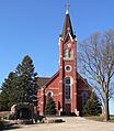
St. Boniface Catholic Church Complex
In Menominee, Nebraska, the St. Boniface Catholic Church Complex is on Main Street. This group of church buildings was added to the National Register in 1983.
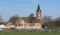
Saints Peter and Paul Catholic Church Complex
The Saints Peter and Paul Catholic Church Complex is located in Bow Valley, Nebraska, at 106 West 889th Road. This historic church complex was listed in 2000.
Saints Philip and James Parochial School
Near Wynot, Nebraska, you'll find the Saints Philip and James Parochial School at 89039 570 Avenue. This old school building was added to the list in 2003.
Schulte Archeological Site
The Schulte Archeological Site is a special place near St. Helena, Nebraska. An archeological site is where scientists study old human history by digging up artifacts. This site was listed in 1974, and its exact location is kept secret to protect it.
Wiseman Archeological Site
Another important archeological site is the Wiseman Archeological Site, near Wynot, Nebraska. It was added to the list in 1974, and its address is also restricted for protection.
Franz Zavadil Farmstead
The Franz Zavadil Farmstead is a historic farm near Menominee, Nebraska. This farm was recognized as a historic place in 1985.
Places That Were Once Listed
Sometimes, a place that was on the National Register of Historic Places might be removed from the list. This usually happens if the building or site is no longer there, or if it has changed too much.
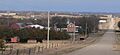
Bow Valley Mills
The Bow Valley Mills were located north of Wynot, Nebraska. They were added to the list in 1978 but were removed in 2016. The mill building itself is no longer there, but you can still see a concrete spillway across the road.
Images for kids
-
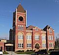
The Cedar County Courthouse in Hartington.
-
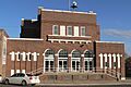
The Hartington City Hall and Auditorium.
-
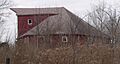
The historic Couser Barn near Laurel.
-
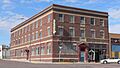
The Hartington Hotel.
-
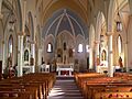
Inside the Immaculate Conception Catholic Church in St. Helena.
-
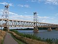
The Meridian Bridge over the Missouri River.
-
The St. Boniface Catholic Church Complex in Menominee.
-
The Saints Peter and Paul Catholic Church Complex in Bow Valley.
-
The Saints Philip and James Parochial School in Wynot.
-
The Franz Zavadil Farmstead.
-
The site of the former Bow Valley Mills.


_church_and_cemetery_from_S.JPG)


