
National Register of Historic Places listings in Codington County, South Dakota facts for kids

This page lists special old buildings and places in Codington County, South Dakota that are on the National Register of Historic Places. Think of this list as a way to protect and remember important parts of history!
The National Register of Historic Places is like a special club for buildings, sites, districts, objects, and structures that are important to American history, architecture, archaeology, engineering, or culture. When a place is on this list, it means it's recognized as a valuable part of our past.
In Codington County, South Dakota, there are 43 places currently on this important list. One place that used to be on the list has since been removed.
Contents
- Historic Places in Codington County
- Watertown's Historic Buildings
- E.C. Adams House
- Carnegie Free Public Library
- Benjamin H. Cartford House
- Codington County Courthouse
- Amy A. Davis House
- Curt E. DeGraff House
- Evangelical United Brethren Church
- James W. Ferris House
- C.E. and Bertha Fowler House
- Dr. H.M. Freeburg House
- A.C. Gilruth House
- John B. Hanten House
- Dr. Harry Henningson House
- A. Einar Johnson House
- Mabel and David Jones House
- Kemp Avenue Bridge
- Mathiesen House
- Peter Mauseth House
- Andrew and Lulu Melham House
- Mellette House
- Minneapolis and St. Louis Railroad Depot
- Mount Hope Cemetery Mausoleum
- Olive Place
- Gen. Mark W. Sheafe House
- South Dakota Dept. of Transportation Bridge No. 15-210-136
- Dr. Tarbell House
- Watertown Commercial Historic District
- Watertown Post Office
- Watertown Stadium
- Walter Willson House
- Zech Farmstead
- Historic Places in Other Codington County Towns
- Barr Farmstead (Florence)
- Beskow Barn (South Shore)
- Citizens State Bank of Henry (Henry)
- Corson Emminger Round Barn (Watertown area)
- Florence Methodist Church (Florence)
- Goodhue Lutheran Church (Florence)
- Nels M. Hanson Farmstead (Henry)
- Holy Rosary Church (Kranzburg)
- Kranzburg School District No. 5 (Kranzburg)
- Puhlman Farm (Hazel)
- Reeve's Resort (Florence)
- Nicholas T. Ries Farmstead (Kranzburg)
- Watertown's Historic Buildings
- Former Listings
- Images for kids
Historic Places in Codington County
Here are some of the cool historic places you can find in Codington County:
Watertown's Historic Buildings
Many historic buildings are located in Watertown, South Dakota, the biggest city in Codington County.
E.C. Adams House
The E.C. Adams House is a historic home located at 604 N. Maple in Watertown. It was added to the National Register on January 3, 1989.
Carnegie Free Public Library

The Carnegie Free Public Library is a beautiful old library building at 27 1st Ave., SE. in Watertown. It joined the list on June 18, 1976. Libraries like this were often built with money from a famous businessman named Andrew Carnegie.
Benjamin H. Cartford House
Another historic home, the Benjamin H. Cartford House, is found at 803 N. Maple in Watertown. It was listed on January 3, 1989.
Codington County Courthouse

The Codington County Courthouse is an important government building at 1st Ave., SE. in Watertown. It was added to the National Register on July 24, 1978. Courthouses are often grand buildings because they are central to a county's government and history.
Amy A. Davis House
The Amy A. Davis House is a historic residence at 20 4th Ave., NW. in Watertown. It was listed on January 3, 1989.
Curt E. DeGraff House
You can find the Curt E. DeGraff House at 603 N. Park in Watertown. This house was added to the list on January 3, 1989.
Evangelical United Brethren Church
The Evangelical United Brethren Church, located at 409 N. Maple in Watertown, is a historic church building. It was recognized on January 3, 1989.
James W. Ferris House
The James W. Ferris House is another historic home in Watertown, found at 619 N. Park. It was added to the National Register on January 3, 1989.
C.E. and Bertha Fowler House
The C.E. and Bertha Fowler House is a historic residence at 316 1st Ave., SE. in Watertown. It was listed on February 9, 2001.
Dr. H.M. Freeburg House
The Dr. H.M. Freeburg House is at 501 N. Park in Watertown. This home was added to the list on January 3, 1989.
A.C. Gilruth House
The A.C. Gilruth House is a historic home located at 218 2nd Ave., NE. in Watertown. It was listed on January 3, 1989.
John B. Hanten House
The John B. Hanten House is at 518 E. Kemp Ave. in Watertown. It was added to the National Register on January 26, 1990.
Dr. Harry Henningson House
The Dr. Harry Henningson House is a historic residence at 802 1st St., NW. in Watertown. It was listed on January 3, 1989.
A. Einar Johnson House
The A. Einar Johnson House is found at 803 1st St., NW. in Watertown. This home was added to the list on January 3, 1989.
Mabel and David Jones House
The Mabel and David Jones House is a historic home at 425 N. Park in Watertown. It was listed on November 8, 2001.
Kemp Avenue Bridge
The Kemp Avenue Bridge crosses the Big Sioux River in Watertown. This bridge was recognized for its historical importance on December 9, 1993.
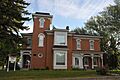
Mathiesen House

The Mathiesen House is a historic home at 914 N. Maple in Watertown. It was added to the National Register on February 1, 1982.
Peter Mauseth House
The Peter Mauseth House is located at 703 N. Maple in Watertown. It was listed on January 3, 1989.
Andrew and Lulu Melham House
The Andrew and Lulu Melham House is a historic home at 721 1st. St., NW in Watertown. It was added to the list on July 28, 2011.
Mellette House

The Mellette House is a very important historic home at 421 5th Ave., NW. in Watertown. It was listed on August 13, 1976. This house was once the home of Arthur C. Mellette, the last governor of the Dakota Territory and the first governor of South Dakota.
Minneapolis and St. Louis Railroad Depot

The Minneapolis and St. Louis Railroad Depot is an old train station at 168 N. Broadway in Watertown. It was added to the National Register on October 31, 1985. Train stations were very important for travel and trade in the past!
Mount Hope Cemetery Mausoleum
The Mount Hope Cemetery Mausoleum is a historic building within Mount Hope Cemetery in Watertown, located off U.S. Route 81. It was listed on August 13, 1986. A mausoleum is a building where people are buried.
Olive Place
Olive Place is a historic site north of Watertown, off U.S. Route 81. It was added to the National Register on May 23, 1978.
Gen. Mark W. Sheafe House
The Gen. Mark W. Sheafe House is a historic home at 57 4th Ave., NW. in Watertown. It was listed on February 26, 1987.
South Dakota Dept. of Transportation Bridge No. 15-210-136
This bridge is a historic structure on a local road over an unnamed creek near Watertown. It was added to the list on December 9, 1993.
Dr. Tarbell House
The Dr. Tarbell House is a historic home at 304 2nd Ave., SE. in Watertown. It was listed on June 6, 2001.
Watertown Commercial Historic District
The Watertown Commercial Historic District is a whole area in downtown Watertown with many historic buildings. It's roughly bounded by 1st Ave., N., 3rd St., E., 2nd Ave., S., and 1st St., W. This district was recognized on July 13, 1989.
Watertown Post Office

The Watertown Post Office is a historic building at 26 S. Broadway in Watertown. It was added to the National Register on December 12, 1976.
Watertown Stadium
The Watertown Stadium, located at 1600 W. Kemp Ave. in Watertown, is a historic sports venue. It was listed on July 5, 2000.
Walter Willson House
The Walter Willson House is a historic home at 702 2nd St., NE. in Watertown. It was added to the list on January 3, 1989.
Zech Farmstead
The Zech Farmstead is a historic farm located at 16676 456th Ave. near Watertown. It was listed on March 31, 2005.
Historic Places in Other Codington County Towns
Barr Farmstead (Florence)
The Barr Farmstead is a historic farm at 15539 444th Ave. near Florence, South Dakota. It was added to the National Register on August 4, 2005.
Beskow Barn (South Shore)
The Beskow Barn is a historic barn located at 15689 456th Ave. near South Shore, South Dakota. It was listed on October 24, 2003. Barns are important for understanding farming history.
Citizens State Bank of Henry (Henry)
The Citizens State Bank of Henry is a historic bank building at the junction of Main and 2nd Sts. in Henry, South Dakota. It was added to the list on November 7, 1997.
Corson Emminger Round Barn (Watertown area)

The Corson Emminger Round Barn is a unique, tall round barn built by farmer Corson Emminger between 1909 and 1910. It's made of concrete blocks and has a two-tier roof with a small tower called a cupola. It's located south of Watertown on U.S. Route 81 and was listed on March 30, 1978.
Florence Methodist Church (Florence)
The Florence Methodist Church is a historic church building at the junction of 5th St. and Dolly Ave. in Florence, South Dakota. It was added to the National Register on June 28, 1991.
Goodhue Lutheran Church (Florence)
The Goodhue Lutheran Church is a historic church at 15555 441st Ave. near Florence, South Dakota. It was listed on July 17, 1996.
Nels M. Hanson Farmstead (Henry)
The Nels M. Hanson Farmstead is a historic farm about 4 miles north of Henry, South Dakota. It was recognized on July 13, 1989.
Holy Rosary Church (Kranzburg)
The Holy Rosary Church is a historic church building on Minnesota Ave. in Kranzburg, South Dakota. It was added to the National Register on June 6, 1986.
Kranzburg School District No. 5 (Kranzburg)
The Kranzburg School District No. 5 building, located on Hasting St. in Kranzburg, South Dakota, is a historic school. It was listed on June 28, 1991. Old schoolhouses tell us a lot about education in the past.
Puhlman Farm (Hazel)
The Puhlman Farm is a historic farm at 44350 176th St. near Hazel, South Dakota. It was added to the National Register on October 24, 2003.
Reeve's Resort (Florence)
Reeve's Resort is a historic site about 6 miles south of Florence, South Dakota. It was listed on October 19, 1989.
Nicholas T. Ries Farmstead (Kranzburg)
The Nicholas T. Ries Farmstead is a historic farm located off Codington County Highway 3 near Kranzburg, South Dakota. It was recognized on February 11, 1988.
Former Listings
Sometimes, a place that was once on the National Register of Historic Places might be removed. This can happen if the building is torn down, or if it changes so much that it no longer meets the requirements to be considered historic.
Here are some places that used to be on the list in Codington County:
- Appleby Atlas Elevator: This elevator, located south of the junction of Interstate 29 and U.S. Route 212 near Watertown, was listed on June 21, 1990, but was removed on August 1, 2012, because it was torn down.
- Halse Halfway House: This house, about 6 miles north of Florence, was listed on June 5, 1975, and removed on June 9, 1987.
- Larson Bridge: This bridge, on a local road over Willow Creek near Watertown, was listed on December 9, 1993, and removed on December 15, 1999.
- Watertown Light and Power Company Plant: This plant at 524 W. Kemp Street in Watertown was listed on July 30, 1989, and removed on May 1, 2001.
Images for kids
-
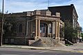
The Carnegie Free Public Library in Watertown
-
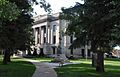
The Codington County Courthouse
-
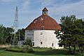
The Corson Emminger Round Barn
-
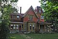
The Mathiesen House in Watertown
-
The Mellette House in Watertown
-
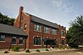
The Minneapolis and St. Louis Railroad Depot
-
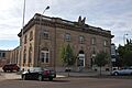
The Watertown Post Office
