
National Register of Historic Places listings in Copiah County, Mississippi facts for kids

This article is about the cool historic places in Copiah County, Mississippi, that are listed on the National Register of Historic Places. Think of the National Register as a special list of buildings, sites, and objects that are important to American history, architecture, archaeology, engineering, or culture. When a place is on this list, it means it's recognized for its special value and efforts are made to protect it.
In Copiah County, Mississippi, there are 35 places that are currently on this important list. There were also two other places that were once on the list but have since been removed. This list helps us learn about the past and appreciate the unique history of Copiah County!
Contents
Cool Historic Places in Copiah County
Copiah County is home to many interesting buildings and sites that tell stories from the past. Here are some of the places that have been recognized for their historical importance:
Historic Homes
Many old houses in Copiah County have been added to the National Register. These homes often show us how people lived long ago and the different styles of architecture that were popular.
- Ailes House: Located in Crystal Springs, this house was added to the list in 1991.
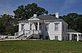
- Alford-Little House: Found south of Georgetown, this house became a historic listing in 1982.
- Brewer Place: Another Crystal Springs home, listed in 2016.
- Cherry Grove: This historic spot in Crystal Springs was recognized in 1990.
- Cook House: In Hazlehurst, this house joined the list in 1983.
- George Washington Copley House: A Crystal Springs home listed in 1996.
- Robert L. Covington House: This Hazlehurst house, listed in 1984, was designed by a famous architect named George Franklin Barber.
- Isaac Newton Ellis House: Also in Hazlehurst, this house was listed in 1987 and was another design by George Franklin Barber.
- Hargrave House: Located west of Hazlehurst, this house was added in 1993.
- Charles Morris Huber House: A Crystal Springs home listed in 1994.
- Dr. William Little House: Found in Wesson, this house became a historic listing in 1993.
- Mount Hope: Located near Hazlehurst, this site was listed in 1985.
- C.H. Parsons House: A Crystal Springs home listed in 1984.
- Dr. Robert W. Rea House: This Wesson house was recognized in 1996.
- James Samuel Rea House: Another Wesson home, listed in 1996.
- Jenkins H. Welch House: Located near Hazlehurst, this house was added in 1988.
- Col. William James Willing House: A Crystal Springs home, listed in 1992.
Important Buildings and Districts
Beyond individual homes, some larger areas or public buildings are also recognized for their history.
- Carpenter United Methodist Church: This church near Utica was listed in 1996.
- Crystal Springs Historic District: A whole area in Crystal Springs, including many streets, was recognized in 1997 for its historic value.
- Gallman Historic District: Similarly, a historic area in Gallman was listed in 1986.
- Georgetown Methodist Church: This church in Georgetown was added to the list in 2016.
- Hazlehurst Historic District: A large historic area in Hazlehurst was recognized in 1998.
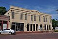
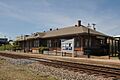
- Illinois Central Railroad Passenger Depot: This old train station in Hazlehurst was listed in 1996. Train stations were very important for travel and trade in the past!
- Marchetti Farm: This farm in Hazlehurst was listed in 1996.
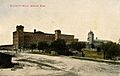
- Mississippi Mills Packing and Shipping Rooms: Located in Wesson, these old mill buildings were listed in 1996.
- Old Wesson Public School Building: This former school in Wesson was recognized in 1980.
- Pleasant Valley Methodist Church: This church near Hazlehurst was listed in 1996.
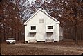
- Tabernacle Methodist Church: Another church near Hazlehurst, listed in 1996.
- US Post Office-Crystal Springs: The old post office in Crystal Springs was added to the list in 1993.
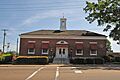
- US Post Office-Hazlehurst: The old post office in Hazlehurst was also listed in 1993.
- Wesson Presbyterian Church: This church in Wesson was recognized in 2015.
Historic Bridges
Bridges are also important parts of history, showing how people built connections and traveled.
- Bayou Pierre Bridge: This bridge near Carpenter was listed in 2005.
- Gatesville Bridge: This bridge spans the Pearl River near Gatesville and was listed in 1988. It even extends into Simpson County!
- Homochitto River Bridge: This bridge near Hazlehurst was listed in 1988.
- Pearl River Bridge on Mississippi Highway 28: Another bridge over the Pearl River near Georgetown, listed in 2005.
Places No Longer Listed
Sometimes, places are removed from the National Register. This can happen if they are destroyed or if they lose their historic importance.
- Rockport Bridge: This bridge over the Pearl River near Georgetown was listed in 1988 but was removed in 1999 because it collapsed in February 1999.
- Wesson Hotel: This hotel in Wesson was listed in 1972 but was removed in 1987 because its owner tore it down in 1982.
Images for kids
-

The Alford-Little House in Georgetown.
-
The Cook House in Hazlehurst.
-
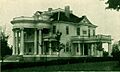
The Robert L. Covington House in Hazlehurst.
-
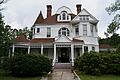
The Isaac Newton Ellis House in Hazlehurst.
-
A view of the Hazlehurst Historic District.
-
The Illinois Central Railroad Passenger Depot in Hazlehurst.
-
The Mississippi Mills Packing and Shipping Rooms in Wesson.
-
The Tabernacle Methodist Church near Hazlehurst.
-
The US Post Office in Hazlehurst.


