
National Register of Historic Places listings in Dent County, Missouri facts for kids

This page tells you about special places in Dent County, Missouri, that are listed on the National Register of Historic Places. This is like a national list of important buildings, sites, and objects that are worth saving because of their history.
These places are recognized by the United States government for their historical or architectural importance. Dent County has 8 of these amazing places!
Exploring Historic Places in Dent County
Dent County is home to several historic sites that tell stories about the past. These places are protected to help us remember and learn about history. Let's explore some of them!
Dent County Courthouse: A Community Landmark
The Dent County Courthouse is a very important building in Salem, Missouri. It's located right in the middle of town, at Main and 4th Streets. This building has been a key part of the community for a long time. It was added to the National Register of Historic Places in 1972. Courthouses are often central to a county's history and government.

Lower Parker School: Learning in the Ozarks
Imagine going to school in a place like this! The Lower Parker School is found on the eastern bank of the Current River. It's part of the beautiful Ozark National Scenic Riverways. This old schoolhouse shows us what education might have been like many years ago in this rural area. It became a historic place in 1991.

Nichols Farm District: A Glimpse of Farm Life
The Nichols Farm District is located west of County Road V, near the Current River, close to Cedargrove, Missouri. This area helps us understand what farm life was like in the past. It includes old buildings and land that show how people lived and worked on farms long ago. The Nichols Farm District was added to the list in 1989.

Montauk State Park: Nature and History Combined
Montauk State Park is a beautiful park off Route 119 near Salem, Missouri. It's known for its natural beauty and great fishing. But it also has several historic structures listed on the National Register:
- Dam and Spillway in the Hatchery Area: This structure helps manage water for fish hatcheries. It was recognized in 1985.
- Montauk State Park Open Shelter: This shelter provides a place for visitors to relax. It was also listed in 1985.
- Old Mill at Montauk State Park: This old mill is a reminder of how people used to process grains. It was added to the list in 1985.
These structures show how people used the natural resources of the park in the past.
Nova Scotia Ironworks Historic District: Industrial History
The Nova Scotia Ironworks Historic District is located within the Mark Twain National Forest. This site tells the story of early industry in the area. Ironworks were places where iron was made, which was very important for building things in the past. This historic district was recognized in 2003.
W.A. Young House: A Historic Home
The W.A. Young House is a historic home located on County Road 513 near Salem, Missouri. Old houses like this can tell us a lot about how people lived and what kind of architecture was popular in different time periods. This house was added to the National Register in 1989.
Images for kids
-
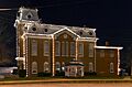
The Dent County Courthouse in Salem, Missouri.
-
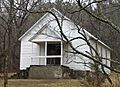
The historic Lower Parker School House.
-
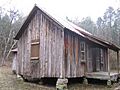
A cabin at the Nichols Farm District.
