Salem, Missouri facts for kids
Quick facts for kids
Salem, Missouri
|
|
|---|---|
| City of Salem | |
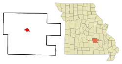
Location of Salem, Missouri
|
|
| Country | United States |
| State | Missouri |
| County | Dent |
| Township | Spring Creek East, Spring Creek West |
| Government | |
| • Type | Mayor–council government |
| Area | |
| • Total | 3.48 sq mi (9.01 km2) |
| • Land | 3.48 sq mi (9.01 km2) |
| • Water | 0.00 sq mi (0.00 km2) |
| Elevation | 1,168 ft (356 m) |
| Population
(2020)
|
|
| • Total | 4,608 |
| • Density | 1,324.52/sq mi (511.41/km2) |
| Time zone | UTC-6 (Central (CST)) |
| • Summer (DST) | UTC-5 (CDT) |
| ZIP code |
65560
|
| Area code(s) | 573 |
| FIPS code | 29-65234 |
| GNIS feature ID | 2396528 |
| Website | https://www.salemmo.com/ |
Salem is a city in Missouri, United States. It is the main city, or county seat, of Dent County. In 2020, about 4,608 people lived there.
Salem is located near the beautiful Ozark National Scenic Riverways. It is also close to Montauk State Park. This park is special because it's where the Current River begins. The name Salem comes from the Hebrew word Shalom, which means "peace."
Contents
Discovering Salem's History
Dent County was first explored between 1818 and 1829. In 1851, the state of Missouri created Dent County. It was made from parts of Crawford, Shannon, and Texas counties. The county was named after an early settler, Lewis Dent. He was the first person to represent the area in government.
The first courthouse for Dent County was a log building. It was built around 1851 or 1852 on the Wingfield farm, just northeast of Salem. W. P. Williams became Salem's first mayor in 1860. This happened after Missouri passed laws about how village governments should work.
During the American Civil War, soldiers from the 5th Missouri State Militia sometimes stayed in Salem. Village governments were paused during the war. Later, in 1881, Salem officially became a town.
Today, you can learn about the town's past at several museums. These include the Dent County Museum and the Bonebrake Center of Nature and History. There is also a special Downtown Walking Tour to see historic places.
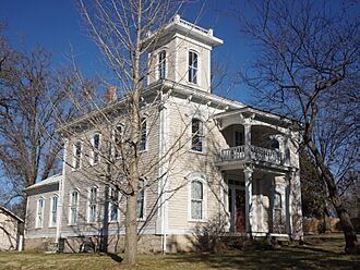
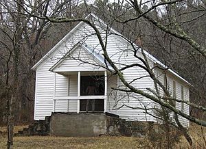
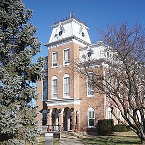
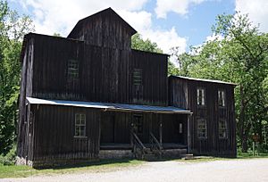
Many important places in and around Salem are listed on the National Register of Historic Places. This means they are protected because of their historical value. Some of these places include the Dent County Courthouse and the Lower Parker School. Also listed are several spots within Montauk State Park, like the Dam and Spillway and the Old Mill.
Salem's Geography and Climate
Salem covers a total area of about 3.18 square miles (8.24 square kilometers). All of this area is land.
Salem's Climate Details
Salem has a humid subtropical climate. This means it has cool winters and warm summers. It also gets a steady amount of rain throughout the year.
| Climate data for Salem, Missouri (1991–2020 normals, extremes 1903–present) | |||||||||||||
|---|---|---|---|---|---|---|---|---|---|---|---|---|---|
| Month | Jan | Feb | Mar | Apr | May | Jun | Jul | Aug | Sep | Oct | Nov | Dec | Year |
| Record high °F (°C) | 84 (29) |
85 (29) |
92 (33) |
93 (34) |
97 (36) |
112 (44) |
111 (44) |
112 (44) |
106 (41) |
93 (34) |
86 (30) |
79 (26) |
112 (44) |
| Mean daily maximum °F (°C) | 42.6 (5.9) |
47.9 (8.8) |
57.3 (14.1) |
68.0 (20.0) |
75.5 (24.2) |
83.2 (28.4) |
87.6 (30.9) |
86.8 (30.4) |
79.5 (26.4) |
68.8 (20.4) |
55.7 (13.2) |
45.2 (7.3) |
66.5 (19.2) |
| Daily mean °F (°C) | 32.2 (0.1) |
36.7 (2.6) |
45.8 (7.7) |
56.1 (13.4) |
64.3 (17.9) |
72.0 (22.2) |
76.3 (24.6) |
75.1 (23.9) |
67.5 (19.7) |
56.8 (13.8) |
45.2 (7.3) |
35.6 (2.0) |
55.3 (12.9) |
| Mean daily minimum °F (°C) | 21.8 (−5.7) |
25.6 (−3.6) |
34.2 (1.2) |
44.2 (6.8) |
53.1 (11.7) |
60.9 (16.1) |
64.9 (18.3) |
63.4 (17.4) |
55.5 (13.1) |
44.9 (7.2) |
34.7 (1.5) |
26.0 (−3.3) |
44.1 (6.7) |
| Record low °F (°C) | −28 (−33) |
−23 (−31) |
−8 (−22) |
13 (−11) |
29 (−2) |
30 (−1) |
44 (7) |
39 (4) |
27 (−3) |
16 (−9) |
−2 (−19) |
−21 (−29) |
−28 (−33) |
| Average precipitation inches (mm) | 2.69 (68) |
2.81 (71) |
4.04 (103) |
4.98 (126) |
5.63 (143) |
4.22 (107) |
3.68 (93) |
4.33 (110) |
4.03 (102) |
3.71 (94) |
3.93 (100) |
2.95 (75) |
47.00 (1,194) |
| Average snowfall inches (cm) | 0.2 (0.51) |
0.4 (1.0) |
0.5 (1.3) |
0.0 (0.0) |
0.0 (0.0) |
0.0 (0.0) |
0.0 (0.0) |
0.0 (0.0) |
0.0 (0.0) |
0.0 (0.0) |
0.1 (0.25) |
0.1 (0.25) |
1.3 (3.3) |
| Average precipitation days (≥ 0.01 in) | 8.7 | 9.0 | 10.4 | 10.6 | 12.0 | 9.5 | 9.0 | 8.2 | 7.0 | 8.3 | 9.3 | 9.0 | 111.0 |
| Average snowy days (≥ 0.1 in) | 0.2 | 0.2 | 0.1 | 0.0 | 0.0 | 0.0 | 0.0 | 0.0 | 0.0 | 0.0 | 0.1 | 0.1 | 0.7 |
| Source: NOAA | |||||||||||||
People Living in Salem
| Historical population | |||
|---|---|---|---|
| Census | Pop. | %± | |
| 1870 | 280 | — | |
| 1880 | 1,624 | 480.0% | |
| 1890 | 1,815 | 11.8% | |
| 1900 | 1,481 | −18.4% | |
| 1910 | 1,796 | 21.3% | |
| 1920 | 1,771 | −1.4% | |
| 1930 | 2,250 | 27.0% | |
| 1940 | 3,151 | 40.0% | |
| 1950 | 3,611 | 14.6% | |
| 1960 | 3,870 | 7.2% | |
| 1970 | 4,363 | 12.7% | |
| 1980 | 4,454 | 2.1% | |
| 1990 | 4,486 | 0.7% | |
| 2000 | 4,854 | 8.2% | |
| 2010 | 4,950 | 2.0% | |
| 2020 | 4,608 | −6.9% | |
| U.S. Decennial Census | |||
Salem's Population in 2010
In 2010, the census counted 4,950 people living in Salem. There were 2,152 households, which are groups of people living together. About 28.5% of these households had children under 18. The average age of people in Salem was 39.5 years.
Education in Salem
Salem High School is the only high school in the city. Salem also has a branch of Southwest Baptist University, where students can continue their education. For reading and learning, the city has the Salem Public Library.
Notable People from Salem
Many interesting people have come from Salem, Missouri. Here are a few:
- James Yancy Callahan: He was a delegate who represented the Oklahoma Territory in the United States House of Representatives.
- Ben Cantwell: A professional MLB baseball player.
- Orien Crow: A professional NFL football player.
- William P. Elmer: He served as a U.S. Representative for Missouri.
- Ralph K. Hofer: A brave fighter pilot in World War II. He received the Distinguished Flying Cross (United States).
- Elmer Jacobs: Another professional MLB baseball player.
- Doug Dillard and Mitchell F. Jayne: These two were bluegrass musicians from the band The Dillards.
- Paulette Jiles: A talented novelist and poet.
- Jason T. Smith: He is a current U.S. Representative for Missouri.
See also
 In Spanish: Salem (Misuri) para niños
 | Ernest Everett Just |
 | Mary Jackson |
 | Emmett Chappelle |
 | Marie Maynard Daly |


