
National Register of Historic Places listings in Doña Ana County, New Mexico facts for kids

Doña Ana County in New Mexico is home to many amazing places that are listed on the National Register of Historic Places. This special list helps protect important buildings, sites, and areas across the United States. When a place is on this list, it means it has a unique history and is worth preserving for future generations.
In Doña Ana County, there are 34 different places on the National Register. Two of these are even more special, called National Historic Landmarks, which means they are important to the history of the entire country! All these local historic places are also recognized by the State of New Mexico. Let's explore some of these cool historic spots!
Contents
Historic Treasures of Doña Ana County
Doña Ana County has a rich history, from old university buildings to ancient trails and important community centers. These sites tell stories about the people who lived here and the events that shaped the area.
Important Buildings and Sites
Many individual buildings in Doña Ana County have been recognized for their historical value. They often show different styles of architecture or played a key role in the community.
New Mexico State University Buildings
The New Mexico State University (NMSU) campus in Las Cruces has several buildings on the National Register.
- Air Science (now the William Conroy Honors Center) was listed in 1989. It's an important part of the university's history.
- Foster Hall and Goddard Hall are also historic buildings on the NMSU campus, recognized for their architecture and role in the university's development.
- The University President's House was built a long time ago and has been home to many NMSU presidents.
Historic Homes
Some old houses in the county are also on the list, showing how people lived in the past.
- The Nestor Armijo House in Las Cruces, listed in 1976, is a beautiful example of historic architecture.
- The Barela-Reynolds House near Mesilla is another historic home. It's even a State Historic Site, meaning it's managed to help people learn about its past.
- The Hadley-Ludwick House and Frank and Amelia Jones House in La Mesa are also recognized for their historical importance.
Community Hubs
Places where people gathered and community life happened are also preserved.
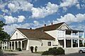
- The Thomas Branigan Memorial Library in Las Cruces, listed in 2004, was the original library building. It served the community for many years before a new library was built. Today, it's known as the Branigan Cultural Center.
- Chope's Town Cafe and Bar in La Mesa is a local favorite and a historic spot where people have gathered for generations.
- The Rio Grande Theatre in Las Cruces, listed in 2004, is a classic movie theater that has been a center for entertainment and arts in the city.
- Phillips Chapel CME Church in Las Cruces is a historic church that has served its community for a long time.
Schools
Even schools can be historic!
- The Paul Laurence Dunbar Elementary School in Vado was listed in 2017. It represents an important part of the area's educational history.
- Mesilla Park Elementary School in Las Cruces is another school building recognized for its historical significance.
Historic Districts and Villages
Sometimes, it's not just one building, but a whole area or group of buildings that is important. These are called historic districts.
Mesilla Plaza and Historic District
The village of Mesilla is especially rich in history.
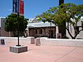
- Mesilla Plaza is a very famous National Historic Landmark. It's the heart of Mesilla and has seen many important events, including the Gadsden Purchase flag raising in 1854, which made Mesilla part of the United States.
- The La Mesilla Historic District includes the plaza and many surrounding buildings, preserving the unique look and feel of this old village.
Other Historic Areas
Other communities in Doña Ana County also have historic districts.
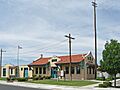
- The Alameda-Depot Historic District in Las Cruces includes properties around Pioneer Park and Alameda Boulevard, showing the city's early growth.
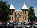
- The Dona Ana Village Historic District preserves the historic center of the village of Doña Ana.
- The Mesquite Street Original Townsite Historic District in Las Cruces is one of the oldest parts of the city, with many historic homes and buildings.
- The Mesilla Park Historic District in Las Cruces is another area recognized for its historic buildings and layout.
Important Landmarks and Infrastructure
Beyond buildings, some natural features, military sites, and old transportation routes are also considered historic.
Forts and Military Sites
Doña Ana County has played a role in military history.
- Fort Fillmore near Las Cruces was an important military post in the mid-1800s.
- Fort Selden, located north of Las Cruces, was a U.S. Army fort established in 1865. It's now a State Historic Site where you can learn about frontier life.
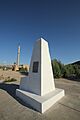
- Launch Complex 33 at White Sands Missile Range is a National Historic Landmark. This is where the first V-2 rockets were launched in the United States after World War II, which was a huge step in space exploration!
Old Roads and Bridges
Transportation routes that connected communities long ago are also preserved.
- Sections of the Camino Real are listed. This was a very old and important road that connected Mexico City to Santa Fe, New Mexico, for hundreds of years. It was used by Spanish explorers, traders, and settlers.
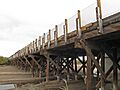
- The Green Bridge in Las Cruces, built over the Rio Grande, is a historic bridge that has served the community for many years.
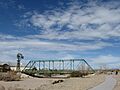
- The Rio Grande Bridge at Radium Springs is another historic bridge crossing the famous Rio Grande river.
Unique Markers
Some historic places are unique markers of boundaries or events.
- International Boundary Marker No. 1, U.S. and Mexico is a significant marker west of El Paso, showing the border between the two countries.
Irrigation and Archeology
Even systems that help grow food and ancient sites are important.
- The Elephant Butte Irrigation District is a large system of canals and dams that brings water to farms in the area. It's a historic example of how people managed water resources.
- The Summerford Mountain Archeological District near Radium Springs is an important site for learning about ancient cultures and the people who lived in this area long before modern times.
Images for kids
-

Air Science building, now the William Conroy Honors Center at NMSU.
-
A building in the Alameda-Depot Historic District in Las Cruces.
-
The historic Nestor Armijo House in Las Cruces.
-

The Barela-Reynolds House, a State Historic Site near Mesilla.
-

The L.B. Bentley General Merchandise building in Organ.
-
The original Thomas Branigan Memorial Library building in Las Cruces.
-

Image for sites with restricted addresses.
-

Chope's Town Cafe and Bar in La Mesa.
-

Entrance to Fort Selden State Historic Site.
-

Foster Hall at New Mexico State University.
-

Goddard Hall at New Mexico State University.
-
The historic Green Bridge in Las Cruces.
-

The Hadley-Ludwick House in Las Cruces.
-
International Boundary Marker No. 1 between the U.S. and Mexico.
-

The Frank and Amelia Jones House in La Mesa.
-
San Albino Church, part of the La Mesilla Historic District.
-
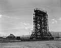
Launch Complex 33 at White Sands Missile Range.
-

Mesilla Park Elementary School, now the Frank O'Brien Papen Community Center.
-

Mesilla Plaza, a National Historic Landmark.
-

Jardin de Mesquite, located in the Mesquite Street Original Townsite Historic District.
-

Our Lady of Purification Catholic Church in Doña Ana.
-

Phillips Chapel CME Church in Las Cruces.
-
The Rio Grande Bridge at Radium Springs.
-

The Rio Grande Theatre in Las Cruces.
-

San Jose Church in La Mesa.
-

The University President's House at New Mexico State University.


.jpg)


