
National Register of Historic Places listings in Fayette County, West Virginia facts for kids
Fayette County, West Virginia, is a place filled with amazing history! Many buildings and areas here are so important that they've been added to a special list called the National Register of Historic Places. This list helps protect and celebrate places that tell us about America's past. In Fayette County, there are 28 such special spots. Let's explore some of them!

Contents
- Exploring Fayette County's Historic Treasures
- Altamont Hotel: A Grand Stay
- Bank of Glen Jean: A Community's Heart
- Camp Washington-Carver Complex: A Place for Culture
- Contentment: A Historic Home
- Fayette County Courthouse: The Center of Law
- Fayetteville Historic District: A Walk Through Time
- Gauley Bridge Railroad Station: A Stop on the Tracks
- E. B. Hawkins House: Another Historic Home
- Kay Moor: A Coal Mining Past
- Main Building at WVU Institute of Technology: Education's Foundation
- Mount Hope Historic District: A Town's Story
- New River Company General Office Building: Business History
- New River Gorge Bridge: An Engineering Marvel
- Nuttallburg Coal Mining Complex and Town Historic District: A Mining Town
- Oak Hill Railroad Depot: Another Train Stop
- Page-Vawter House: A Grand Residence
- Prince Brothers General Store-Berry Store: A Community Hub
- Thurmond Historic District: A Railroad Town
- Whipple Company Store: Life in a Coal Town
- Images for kids
Exploring Fayette County's Historic Treasures
Altamont Hotel: A Grand Stay
The Altamont Hotel is a beautiful old building located in Fayetteville. It was added to the National Register of Historic Places in 1979. Hotels like this were once very important places for travelers and local events.

Bank of Glen Jean: A Community's Heart
The Bank of Glen Jean in Glen Jean was built a long time ago. Banks are important because they help people save money and businesses grow. This building shows us what banks looked like in the past. It became a historic place in 1983.

Camp Washington-Carver Complex: A Place for Culture
The Camp Washington-Carver Complex near Clifftop is a special place. It was once a training camp for African American youth. Today, it's a cultural center that celebrates Appalachian arts and heritage. It was added to the list in 1980.

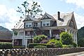
Contentment: A Historic Home
The house known as Contentment is found along U.S. Route 60 in Ansted. This historic home tells us about how people lived many years ago. It was recognized as a historic place in 1974.

Fayette County Courthouse: The Center of Law
The Fayette County Courthouse in Fayetteville is where many important decisions are made for the county. Courthouses are usually grand buildings that show the importance of law and order. This one became historic in 1978.

Fayetteville Historic District: A Walk Through Time
The Fayetteville Historic District includes many old buildings and streets in Fayetteville. Walking through this area is like stepping back in time. It helps us see how the town grew and changed. This district was added to the list in 1990.

Gauley Bridge Railroad Station: A Stop on the Tracks
The Gauley Bridge Railroad Station in Gauley Bridge was once a busy place. Trains were a main way to travel and move goods. This station reminds us of the age of railroads. It was listed in 1980.

E. B. Hawkins House: Another Historic Home
The E. B. Hawkins House is another historic home in Fayetteville. Old houses often have unique designs and stories about the families who lived there. This house was added to the list in 1990.

Kay Moor: A Coal Mining Past
Kay Moor is a historic area along the New River near Fayetteville. It was once a very active coal mining operation. It shows us the history of coal mining in West Virginia. Kay Moor became a historic district in 1990.

Main Building at WVU Institute of Technology: Education's Foundation
The Main Building on the West Virginia University Institute of Technology campus in Montgomery is an important part of the school's history. College buildings often have a long history of teaching and learning. It was listed in 1980.

Mount Hope Historic District: A Town's Story
The Mount Hope Historic District in Mount Hope includes many parts of the town. Historic districts help preserve the overall look and feel of a community from a certain time period. This district was added to the list in 2007.

New River Company General Office Building: Business History
The New River Company General Office Building in Mount Hope was the main office for a large company. This building shows us how businesses operated in the past. It was listed in 2004.

New River Gorge Bridge: An Engineering Marvel
The New River Gorge Bridge is a very famous landmark. It spans across the New River near Fayetteville. It's one of the longest single-arch bridges in the world. This amazing bridge was added to the list in 2013.

Nuttallburg Coal Mining Complex and Town Historic District: A Mining Town
The Nuttallburg Coal Mining Complex and Town Historic District near Nuttallburg is another site that tells the story of coal mining. It includes the old mining structures and parts of the town where miners lived. It became historic in 2007.

Oak Hill Railroad Depot: Another Train Stop
The Oak Hill Railroad Depot in Oak Hill was another important train station. Depots were busy places where people boarded trains and goods were loaded. This depot was listed in 1995.

Page-Vawter House: A Grand Residence
The Page-Vawter House in Ansted is a beautiful historic home. It shows the architectural styles and living conditions of wealthy families from long ago. It was added to the list in 1985.

Prince Brothers General Store-Berry Store: A Community Hub
The Prince Brothers General Store-Berry Store in Prince was a general store. These stores were very important in small towns, selling everything from food to tools. They were often the heart of the community. This store was listed in 1986.

Thurmond Historic District: A Railroad Town
The Thurmond Historic District near Thurmond is a unique historic area. Thurmond was once a very busy railroad town. It shows how important the railroad was to the area's growth. This district was added to the list in 1984.

Whipple Company Store: Life in a Coal Town
The Whipple Company Store in Scarbro was a store run by a coal company. In many mining towns, company stores were where miners bought everything they needed. This store helps us understand life in a coal town. It was listed in 1991.

Images for kids
-
Glen Ferris Inn, a historic hotel.

