Montgomery, West Virginia facts for kids
Quick facts for kids
City of Montgomery
|
|||||
|---|---|---|---|---|---|

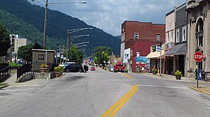
Third Avenue in Montgomery. The Montgomery Amtrak station is on the left.
|
|||||
|
|||||

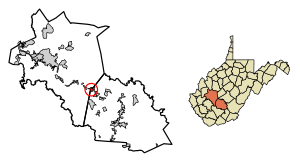
Location of Montgomery in Fayette County, West Virginia
|
|||||
| Country | |||||
| State | |||||
| County | Fayette, Kanawha | ||||
| Area | |||||
| • Total | 1.75 sq mi (4.53 km2) | ||||
| • Land | 1.60 sq mi (4.14 km2) | ||||
| • Water | 0.15 sq mi (0.39 km2) | ||||
| Elevation | 636 ft (194 m) | ||||
| Population
(2020)
|
|||||
| • Total | 1,280 | ||||
| • Estimate
(2021)
|
1,257 | ||||
| • Density | 942.50/sq mi (363.88/km2) | ||||
| Time zone | UTC-5 (Eastern (EST)) | ||||
| • Summer (DST) | UTC-4 (EDT) | ||||
| ZIP code |
25136
|
||||
| Area code(s) | 304 | ||||
| FIPS code | 54-55468 | ||||
| GNIS feature ID | 1555154 | ||||
Montgomery is a city in West Virginia, United States. It is located along the Kanawha River. Most of the city is in Fayette County. A smaller part is in Kanawha County. In 2020, about 1,280 people lived in Montgomery.
Contents
The Story of Montgomery
Montgomery has had a few different names over the years. From 1876 to 1890, it was known as Coal Valley Post Office. Then, it was called Montgomery's Landing, and later, Coal Valley again.
In 1890, its name changed to Cannelton. Finally, on April 1, 1891, the town officially became Montgomery. It was named after James C. Montgomery, who was one of the first people to settle there. James received the land as a wedding gift from his father-in-law, Levi Morris.
How Montgomery Grew
In the late 1800s, Montgomery started to grow a lot. This happened because new railroads were built nearby. The Kanawha & Michigan Railroad was built across the river. Also, the Virginian Railway connected at a place called Deepwater.
By the early 1910s, Montgomery became a very important shipping center. It helped move coal from 26 different mining operations. At that time, it was the biggest town in Fayette County.
Colleges in Montgomery
For many years, Montgomery was home to West Virginia University Institute of Technology, also known as WVU Tech. This college was in Montgomery from 1895 until 2017. It then moved to Beckley.
Today, Montgomery is still a college town. It is home to the Montgomery Campus of BridgeValley Community and Technical College.
Where is Montgomery?
Montgomery is located in West Virginia. The city covers a total area of about 1.59 square miles (4.12 square kilometers). Most of this area, about 1.57 square miles (4.07 square kilometers), is land. The rest, about 0.02 square miles (0.05 square kilometers), is water.
People in Montgomery
| Historical population | |||
|---|---|---|---|
| Census | Pop. | %± | |
| 1900 | 1,594 | — | |
| 1910 | 1,886 | 18.3% | |
| 1920 | 2,130 | 12.9% | |
| 1930 | 2,906 | 36.4% | |
| 1940 | 3,231 | 11.2% | |
| 1950 | 3,484 | 7.8% | |
| 1960 | 3,000 | −13.9% | |
| 1970 | 2,525 | −15.8% | |
| 1980 | 3,104 | 22.9% | |
| 1990 | 2,449 | −21.1% | |
| 2000 | 1,942 | −20.7% | |
| 2010 | 1,638 | −15.7% | |
| 2020 | 1,280 | −21.9% | |
| 2021 (est.) | 1,257 | −23.3% | |
| U.S. Decennial Census | |||
In 2010, there were 1,638 people living in Montgomery. These people lived in 645 households. The city had about 1,043 people per square mile.
The average age of people in Montgomery was about 30 years old. About 13% of residents were under 18. About 31% were between 18 and 24 years old.
Getting Around Montgomery
Trains and Roads
Montgomery has a train station served by Amtrak. Amtrak is the national passenger rail service in the United States. The Cardinal train route stops in Montgomery.
CSX transportation also has freight train services in the area. Major road Route 60 also passes through Montgomery.
Bus Service
If you want to travel by bus, the Kanawha Valley Regional Transportation Authority has a bus route. Bus 22M runs from Montgomery all the way to Charleston.
See also
 In Spanish: Montgomery (Virginia Occidental) para niños
 | Roy Wilkins |
 | John Lewis |
 | Linda Carol Brown |


