
National Register of Historic Places listings in Franklin County, Georgia facts for kids

Welcome to Franklin County, Georgia! This area is home to many special places that are listed on the National Register of Historic Places (NRHP). The NRHP is like a special list kept by the United States government. It helps protect important buildings, sites, and objects that tell us about American history, architecture, and culture. When a place is on this list, it means it's recognized as being very important and worth preserving for future generations.
In Franklin County, you can find many historic homes, schools, and even a covered bridge that are part of this list. Let's explore some of these amazing places!
Contents
Historic Buildings and Districts in Franklin County
Franklin County has many buildings and areas that are important because of their history. These places help us understand what life was like long ago.
Old Schools and Boarding Houses
Some buildings on the list were once places where people learned or lived.
Ayers-Little Boarding House
The Ayers-Little Boarding House is a historic home located at 121 Athens Street in Carnesville, Georgia. It's a one-and-a-half-story house made of wood, found right near the courthouse square. This house was added to the NRHP in 2008.
Baty School
The Baty School, located near Carnesville, Georgia, is another important historic site. It was added to the NRHP in 1996. Schools like Baty School played a big role in educating children in the past.
Historic Homes and Farms
Many of the listed properties are old homes that show us how people used to live and build.
William Ariail House
The William Ariail House is a historic home located on GA 51 near the Banks-Franklin County line, close to Carnesville, Georgia. This house was recognized for its historical value in 1996.
John R. and Mary Bond Bond House
Another interesting home is the John R. and Mary Bond Bond House. It's located on GA 59, northeast of the junction with GA 51, also near Carnesville, Georgia. This house was added to the NRHP in 1996.
Strange-Duncan House
The Strange-Duncan House is found on GA 51, east of the Franklin-Banks County line, near Carnesville, Georgia. It became a listed historic place in 1996.

Important Public Buildings
Public buildings are also a big part of Franklin County's history.
Franklin County Courthouse
The Franklin County Courthouse is a very important building in Carnesville, Georgia. It stands proudly on Courthouse Square. This courthouse was built a long time ago and was added to the NRHP in 1980. It's where many important decisions for the county have been made over the years.

Lavonia Carnegie Library
The Lavonia Carnegie Library is a special building in Lavonia, Georgia, located on Hartwell Road. It was built with money from Andrew Carnegie, a famous businessman who helped build many libraries across the country. This library was added to the NRHP in 1983 and has served the community for many years.

Historic Commercial and Industrial Sites
These sites show us how people worked and traded in the past.
Lavonia Cotton Mill
The Lavonia Cotton Mill, located on Main Street in Lavonia, Georgia, was an important place for making textiles. Cotton mills were a big part of the economy in the South. This mill was listed on the NRHP in 1983.

Lavonia Roller Mill
The Lavonia Roller Mill, on East Main Street in Lavonia, Georgia, was a place where grain was processed. Mills like this were essential for producing food for the community. It was added to the NRHP in 1983.

Southern Cotton Oil Co.
The Southern Cotton Oil Co., located on West Main Street in Lavonia, Georgia, was another important industrial site. It processed cotton seeds to make oil and other products. This company's building was listed on the NRHP in 1983.

Unique Historic Structures
Sometimes, a single structure stands out for its historical significance.
Cromer's Mill Covered Bridge
One of the most interesting historic places in Franklin County is the Cromer's Mill Covered Bridge. It's located about 8 miles south of Carnesville, Georgia, over Nails Creek. Covered bridges are rare and beautiful structures that were once common. This bridge was added to the NRHP in 1976, making it one of the earliest listings in the county. It's a great example of old-time engineering.

Historic Districts
A "historic district" is an area with many buildings or sites that are historically important together.
Canon Commercial Historic District
The Canon Commercial Historic District includes Depot Street between Bond Avenue and Broad Street in Canon, Georgia. This area shows what a busy town center looked like in the past. It was listed in 1985.
Royston Commercial Historic District
The Royston Commercial Historic District is found along Church and Railroad Streets in Royston, Georgia. This district also highlights the historic business areas of the town. It was added to the NRHP in 1985.

Lavonia Commercial Historic District
In Lavonia, Georgia, the Lavonia Commercial Historic District covers several streets, including Jones, Augusta, Vickery, Grogan, and Bowman Streets. This district shows the historic heart of Lavonia's business activity. It was listed in 1983.

Walnut Hill Historic District
The Walnut Hill Historic District is located on GA 51, about 1 mile northwest of the junction with I-85, near Carnesville, Georgia. This district was recognized in 1996.

McConnell Historic District
The McConnell Historic District is also on GA 51, about 2.5 miles northwest of I-85, near Carnesville, Georgia. This area was added to the NRHP in 1996.

Images for kids
-
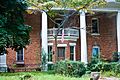
Cheek House in Lavonia.
-
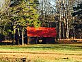
A barn in the Hamilton Historic District.
-
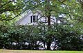
The Yow-Vandiver House in Lavonia.


