Lavonia, Georgia facts for kids
Quick facts for kids
Lavonia, Georgia
|
|
|---|---|

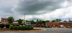
Main Street, Lavonia, Georgia, May 2017
|
|
| Motto(s):
"Home to Land of Spirit",
"Big Time Small Town" |
|

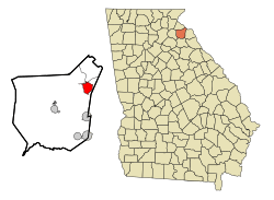
Location in Franklin County and the state of Georgia
|
|
| Country | United States |
| State | Georgia |
| Counties | Franklin, Hart |
| Area | |
| • Total | 4.53 sq mi (11.73 km2) |
| • Land | 4.51 sq mi (11.67 km2) |
| • Water | 0.02 sq mi (0.06 km2) |
| Elevation | 853 ft (260 m) |
| Population
(2020)
|
|
| • Total | 2,143 |
| • Density | 475.59/sq mi (183.61/km2) |
| Time zone | UTC-5 (Eastern (EST)) |
| • Summer (DST) | UTC-4 (EDT) |
| ZIP code |
30553
|
| Area code(s) | 706 |
| FIPS code | 13-45460 |
| GNIS feature ID | 0316687 |
Lavonia is a small city located in the state of Georgia, in the United States. It is found in both Franklin and Hart Counties. In 2020, about 2,143 people lived there. Lavonia is known for its friendly, small-town feel.
Contents
Where is Lavonia Located?
Lavonia is in the northeastern part of Franklin County. A small piece of the city also reaches into Hart County. It covers an area of about 11.9 square kilometers (4.6 square miles). Only a tiny part of this area is water.
The city is right along Interstate 85, a major highway. This makes it easy to travel to bigger cities. Lavonia is about 53 miles (85 km) southwest of Greenville, South Carolina. It is also about 94 miles (151 km) northeast of Atlanta, Georgia's capital.
Lavonia's History
Early Inhabitants: The Cherokee People
Long ago, the Cherokee people lived in the area where Lavonia is now. They were a very advanced tribe. By the 1700s, they lived in cabins. During the American Revolution, the Cherokee joined forces with the British. When the American colonists won the war, the Cherokee's land was given to the soldiers who fought. This led to European Americans moving into the Lavonia area around the 1780s.
How Lavonia Was Founded
The city of Lavonia began because of the expanding railroad system in northeast Georgia. A railroad company, the Elberton-Airline Railroad, wanted a new station further north. Business people in the area decided to build a town around this new station.
The land was divided into town lots. After all the legal steps were finished, the town of Lavonia was officially created in 1880. The community was named after Lavonia Hammond Jones. She was the wife of an important railroad official.
Getting Around Lavonia
Major Roads
Several important roads pass through or near Lavonia, making travel easy.
Local Airports
Lavonia is also home to Broad River Air Park (3GE3). This is a private airport community. It has a 3,000-foot runway that runs next to Interstate 85.
People of Lavonia
| Historical population | |||
|---|---|---|---|
| Census | Pop. | %± | |
| 1880 | 72 | — | |
| 1890 | 283 | 293.1% | |
| 1900 | 699 | 147.0% | |
| 1910 | 1,712 | 144.9% | |
| 1920 | 1,644 | −4.0% | |
| 1930 | 1,511 | −8.1% | |
| 1940 | 1,667 | 10.3% | |
| 1950 | 1,766 | 5.9% | |
| 1960 | 2,088 | 18.2% | |
| 1970 | 2,044 | −2.1% | |
| 1980 | 2,024 | −1.0% | |
| 1990 | 1,840 | −9.1% | |
| 2000 | 1,827 | −0.7% | |
| 2010 | 2,156 | 18.0% | |
| 2020 | 2,143 | −0.6% | |
| U.S. Decennial Census | |||
Population in 2020
In 2020, the city of Lavonia had 2,143 residents. There were 1,029 households and 676 families living in the city. The population has grown over the years.
The people of Lavonia come from many different backgrounds.
| Race | Number of People | Percentage |
|---|---|---|
| White | 1,395 | 65.1% |
| Black or African American | 492 | 22.96% |
| Native American | 5 | 0.23% |
| Asian | 10 | 0.47% |
| Pacific Islander | 10 | 0.06% |
| Other/Mixed | 80 | 3.73% |
| Hispanic or Latino | 161 | 7.51% |
Lavonia Carnegie Library
The Lavonia Carnegie Library is a special building in the city. It was named after a kind person named Andrew Carnegie. He helped build many libraries. This library was built in 1911. It has a beautiful Renaissance Revival style. The building is an important local landmark. It has been used as a library for over 100 years. Lavonia is the smallest city in the entire United States that still has its original Carnegie Library building.
Sports and Fun in Lavonia
Lavonia Speedway
Lavonia is home to the Lavonia Speedway. This is a 3/8-mile dirt oval track where exciting races happen. It hosts several annual races, like the Buck Simmons Memorial and the Rusty Jordan Memorial. From 2018 to 2021, it also hosted an annual event for the World of Outlaws Late Model Series.
Famous People from Lavonia
- FPS Russia: A well-known YouTube personality.
- Ernest Vandiver: He was a mayor of Lavonia. He also served as the governor of Georgia from 1959 to 1963. A governor is the elected leader of a state.
- Omer Clyde "O.C." Aderhold: He was the president of the University of Georgia. He led the university during a time when it began to allow students of all races.
See also
 In Spanish: Lavonia para niños
 | Lonnie Johnson |
 | Granville Woods |
 | Lewis Howard Latimer |
 | James West |

