Hart County, Georgia facts for kids
Quick facts for kids
Hart County
|
|
|---|---|

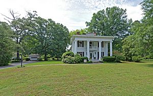
J. Pearl Jones House, completed in 1914. Greek Revival architecture.
|
|

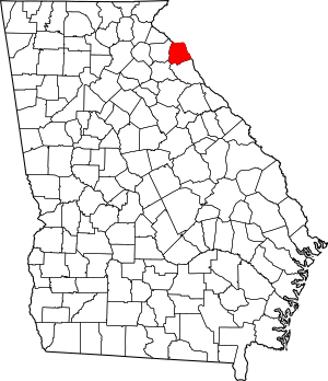
Location within the U.S. state of Georgia
|
|
 Georgia's location within the U.S. |
|
| Country | |
| State | |
| Founded | December 7, 1853 |
| Named for | Nancy Hart |
| Seat | Hartwell |
| Largest city | Hartwell |
| Area | |
| • Total | 257 sq mi (670 km2) |
| • Land | 232 sq mi (600 km2) |
| • Water | 25 sq mi (60 km2) 9.6%% |
| Population
(2020)
|
|
| • Total | 25,828 |
| • Density | 111/sq mi (43/km2) |
| Time zone | UTC−5 (Eastern) |
| • Summer (DST) | UTC−4 (EDT) |
| Congressional district | 9th |
Hart County is a special area in the U.S. state of Georgia. It is located in the Northeast part of the state. In 2020, about 25,828 people lived here. The main town and center of the county is Hartwell.
Hart County was created on December 7, 1853. It was named after Nancy Hart, a brave woman from Georgia's history. It is the only county in Georgia named after a woman. The big Lake Hartwell is also named in her honor.
You might have heard of Hart County from the movie The Color Purple. Letters in the movie were sent to "Hartwell County, Georgia." This suggests the story might take place in or near Hart County.
Contents
Exploring Hart County's Geography
Hart County covers a total area of about 257 square miles. Most of this land, about 232 square miles, is dry land. The rest, about 25 square miles, is water. This means about 9.6% of the county is covered by water.
The county is part of the Piedmont region. This area has rolling hills and is located between the mountains and the coastal plains.
Most of Hart County's southern part is in the Upper Savannah River area. This river basin is a large system of rivers and streams. The northern part of the county is in the Tugaloo River area, which also flows into the Savannah River.
Main Roads in Hart County
Many important roads run through Hart County. These roads help people travel around the county and to other parts of Georgia.
Neighboring Counties
Hart County shares borders with several other counties. These are:
- Oconee County, South Carolina (to the north)
- Anderson County, South Carolina (to the northeast)
- Elbert County (to the south)
- Madison County (to the southwest)
- Franklin County (to the west)
People and Population in Hart County
The number of people living in Hart County has changed over many years. Here's a look at how the population has grown:
| Historical population | |||
|---|---|---|---|
| Census | Pop. | %± | |
| 1860 | 6,137 | — | |
| 1870 | 6,783 | 10.5% | |
| 1880 | 9,094 | 34.1% | |
| 1890 | 10,887 | 19.7% | |
| 1900 | 14,492 | 33.1% | |
| 1910 | 16,216 | 11.9% | |
| 1920 | 17,944 | 10.7% | |
| 1930 | 15,174 | −15.4% | |
| 1940 | 15,512 | 2.2% | |
| 1950 | 14,495 | −6.6% | |
| 1960 | 15,229 | 5.1% | |
| 1970 | 15,814 | 3.8% | |
| 1980 | 18,585 | 17.5% | |
| 1990 | 19,712 | 6.1% | |
| 2000 | 22,997 | 16.7% | |
| 2010 | 25,213 | 9.6% | |
| 2020 | 25,828 | 2.4% | |
| 2023 (est.) | 27,556 | 9.3% | |
| U.S. Decennial Census 1790-1880 1890-1910 1920-1930 1930-1940 1940-1950 1960-1980 1980-2000 2010 |
|||
Population in 2020
In 2020, there were 25,828 people living in Hart County. There were 9,853 households and 6,743 families.
Here's a breakdown of the different groups of people living in Hart County in 2020:
| Race | Number of People | Percentage |
|---|---|---|
| White | 19,250 | 74.53% |
| Black or African American | 4,324 | 16.74% |
| Native American | 36 | 0.14% |
| Asian | 335 | 1.3% |
| Pacific Islander | 2 | 0.01% |
| Other/Mixed | 950 | 3.68% |
| Hispanic or Latino | 931 | 3.6% |
Population in 2010
Back in 2010, Hart County had 25,213 people. The population density was about 108.5 people per square mile.
Most people were white (77.4%). About 18.7% were black or African American. Other groups included Asian, American Indian, and people from two or more races. About 3.1% of the population was Hispanic or Latino.
Fun Places and Attractions
Hart County has many interesting places to visit and things to do:
- Lake Hartwell is a huge man-made lake. It covers 56,000 acres and is great for boating, fishing, and other water sports. It was built to help control floods and for fun activities.
- The Scarecrow Festival happens every October in Hartwell. The downtown area fills up with unique, handmade scarecrows. Local shops and businesses display them, making the town look very festive.
- Cateechee is a beautiful golf course. It has 18 holes and covers 380 acres of land. It's known as one of the best golf courses in Georgia.
- The Hartwell Dam is very important for the county. It creates electricity for many states. You can see it near the Georgia and South Carolina border, close to U.S. Route 29. When the dam starts making power, you can often hear a long fog horn sound.
Towns and Communities
Hart County has several towns and communities where people live.
City
Town
Census-designated places
These are areas that are like towns but are not officially incorporated as cities or towns.
Other Communities
These are smaller communities that are not officially incorporated.
- Air Line
See also
 In Spanish: Condado de Hart (Georgia) para niños
 | James B. Knighten |
 | Azellia White |
 | Willa Brown |

