Elbert County, Georgia facts for kids
Quick facts for kids
Elbert County
|
|
|---|---|

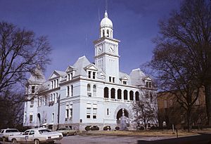
Elbert County courthouse in Elberton, 1973
|
|

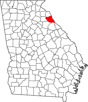
Location within the U.S. state of Georgia
|
|
 Georgia's location within the U.S. |
|
| Country | |
| State | |
| Founded | 1790 |
| Named for | Samuel Elbert |
| Seat | Elberton |
| Largest city | Elberton |
| Area | |
| • Total | 374 sq mi (970 km2) |
| • Land | 351 sq mi (910 km2) |
| • Water | 23 sq mi (60 km2) 6.2%% |
| Population
(2020)
|
|
| • Total | 19,637 |
| • Density | 56/sq mi (22/km2) |
| Time zone | UTC−5 (Eastern) |
| • Summer (DST) | UTC−4 (EDT) |
| Congressional district | 9th |
Elbert County is a county in the northeastern part of Georgia, a state in the United States. In 2020, about 19,637 people lived here. The main town, or county seat, is Elberton. Elbert County was created on December 10, 1790. It was named after Samuel Elbert, an important person in Georgia's history.
Contents
Exploring Elbert County's Geography
Elbert County covers a total area of about 374 square miles. Most of this area, about 351 square miles, is land. The rest, about 23 square miles, is water. This means about 6.2% of the county is covered by water.
Elbert County is located in the Piedmont region of Georgia. The Piedmont is an area of rolling hills and gentle slopes. It sits between the mountains and the coastal plains.
Rivers and Waterways in Elbert County
The northern part of Elbert County is in the Upper Savannah River sub-basin. This means that water in this area flows into the Savannah River. The Savannah River is a major river that forms part of the border between Georgia and South Carolina.
The southern part of the county is in the Broad River sub-basin. The Broad River is another important river in the region. Both of these rivers are part of the larger Savannah River basin. This basin is a large area where all water eventually drains into the Savannah River.
Main Roads in Elbert County
Several important roads run through Elbert County. These roads help people travel around the county and connect to other areas.
 State Route 17
 State Route 72
 State Route 77
 State Route 77 Connector
 State Route 79
 State Route 172
 State Route 368
Counties Near Elbert County
Elbert County shares its borders with several other counties. Some of these are in Georgia, and others are in South Carolina.
- Anderson County, South Carolina (northeast)
- Abbeville County, South Carolina (east)
- McCormick County, South Carolina (southeast)
- Lincoln County (southeast)
- Wilkes County (south)
- Oglethorpe County (southwest)
- Madison County (west)
- Hart County (north)
- Franklin County (northwest)
Towns and Places in Elbert County
Elbert County has several communities where people live. These include cities, a census-designated place, and smaller unincorporated communities.
Cities in Elbert County
Census-Designated Place
- Dewy Rose is a place that the U.S. Census Bureau defines for gathering population data. It is not an officially incorporated city or town.
Unincorporated Communities
These are smaller areas that do not have their own local government.
- Hard Cash
- Ruckersville
- Rice Town
Ghost Town
- Petersburg is a former town that no longer exists as a populated place.
People of Elbert County: Demographics
The population of Elbert County has changed over many years. The U.S. Census counts how many people live in an area every ten years.
| Historical population | |||
|---|---|---|---|
| Census | Pop. | %± | |
| 1800 | 10,094 | — | |
| 1810 | 12,156 | 20.4% | |
| 1820 | 11,788 | −3.0% | |
| 1830 | 12,354 | 4.8% | |
| 1840 | 11,125 | −9.9% | |
| 1850 | 12,959 | 16.5% | |
| 1860 | 10,433 | −19.5% | |
| 1870 | 9,249 | −11.3% | |
| 1880 | 12,957 | 40.1% | |
| 1890 | 15,376 | 18.7% | |
| 1900 | 19,729 | 28.3% | |
| 1910 | 24,125 | 22.3% | |
| 1920 | 23,905 | −0.9% | |
| 1930 | 18,485 | −22.7% | |
| 1940 | 19,618 | 6.1% | |
| 1950 | 18,585 | −5.3% | |
| 1960 | 17,835 | −4.0% | |
| 1970 | 17,262 | −3.2% | |
| 1980 | 18,758 | 8.7% | |
| 1990 | 18,949 | 1.0% | |
| 2000 | 20,511 | 8.2% | |
| 2010 | 20,166 | −1.7% | |
| 2020 | 19,637 | −2.6% | |
| 2023 (est.) | 20,013 | −0.8% | |
| U.S. Decennial Census 1790–1880 1890–1910 1920–1930 1930–1940 1940–1950 1960–1980 1980–2000 2010 |
|||
In 2020, the census showed that 19,637 people lived in Elbert County. These people lived in 7,559 households. About 5,065 of these were families.
Racial Makeup of Elbert County (2020)
The table below shows the different racial groups living in Elbert County in 2020.
| Race | Number of People | Percentage |
|---|---|---|
| White | 12,610 | 64.22% |
| Black or African American | 5,253 | 26.75% |
| Native American | 26 | 0.13% |
| Asian | 182 | 0.93% |
| Pacific Islander | 3 | 0.02% |
| Other/Mixed Race | 567 | 2.89% |
| Hispanic or Latino | 996 | 5.07% |
Historical and Cultural Places to Visit
Elbert County has many interesting places that tell stories about its past and culture.
Some of these sites include:
- The Nancy Hart cabin, home of a famous rebel heroine.
- The Dan Tucker gravesite.
- The Stephen Heard Cemetery.
- The Petersburg Township site, a former town.
- Vans Creek Church.
- The Elbert County Courthouse, an important government building.
- The Elberton Seaboard-Airline Depot, an old train station.
- The Rock Gym.
- The Granite Bowl, a sports stadium.
- The Elberton Granite Museum and Exhibit, which shows the county's history with granite.
- The Richard B. Russell Dam.
- The Elbert Theatre, a historic theater.
- Richard B. Russell State Park, a great place for outdoor activities.
- Bobby Brown Park.
The Georgia Guidestones, a set of large granite monuments, used to stand in Elbert County from 1980 until 2022.
Famous People from Elbert County
Many notable people have connections to Elbert County. Here are a few:
- Warren Akin Sr. was a member of the Georgia House of Representatives. He also served in the Confederate States Congress.
- Milton Alexander was a high-ranking military officer. He was a brigadier general during the Black Hawk War.
- William J. Alston served in the U.S. House of Representatives. He was also part of the Alabama House and Senate.
- Richard E. Banks was a doctor and surgeon.
- William Barnett served in the U.S. House of Representatives.
- William Augustus Bell was an academic and president of Miles College.
- Fred Bond Jr. worked in the tobacco industry. He also served as mayor of Cary, North Carolina.
- Nathaniel J. Hammond was a U.S. Representative. He also served as Georgia's Attorney General.
- Mecole Hardman is a professional football player.
- Derek Harper is a professional basketball player.
- Corra Mae Harris was a journalist and war correspondent.
- Sampson Willis Harris served in the U.S. House of Representatives. He was also in the Georgia House of Representatives.
- Nancy Hart was a rebel heroine during the American Revolutionary War.
- William Henry Heard was a religious leader and diplomat.
- R. H. Hunt was a well-known architect.
- Mammy Kate was an enslaved woman known for her bravery.
- Joseph Rucker Lamar became a justice on the U.S. Supreme Court.
- Otis Leavill was an R&B singer, songwriter, and record company executive.
- Daniel Parker was a leader in the Primitive Baptist Church.
- Charles Tait was a U.S. Senator. He also served as a U.S. district judge.
- Horace Tate was an educator, activist, scholar, and politician.
- Daniel Tucker was a Methodist minister and farmer. He was also a captain during the American Revolution.
- Matthias Ward was a lawyer and U.S. Senator from Texas.
- William J. White was a civil rights leader. He was also a minister, educator, and journalist.
- Thomas Simpson Woodward was a brigadier general in the Georgia militia.
See also
 In Spanish: Condado de Elbert (Georgia) para niños
 | Audre Lorde |
 | John Berry Meachum |
 | Ferdinand Lee Barnett |

