McCormick County, South Carolina facts for kids
Quick facts for kids
McCormick County
|
||
|---|---|---|

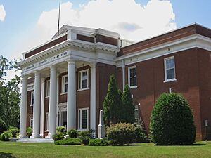
McCormick County Courthouse
|
||
|
||
| Motto(s):
"The Natural Place Of Life"
|
||

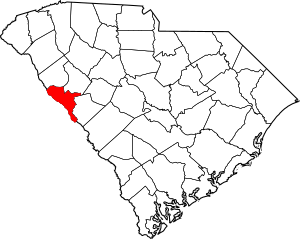
Location within the U.S. state of South Carolina
|
||
 South Carolina's location within the U.S. |
||
| Country | ||
| State | ||
| Founded | 1916 | |
| Named for | Cyrus McCormick | |
| Seat | McCormick | |
| Largest community | McCormick | |
| Area | ||
| • Total | 393.61 sq mi (1,019.4 km2) | |
| • Land | 358.87 sq mi (929.5 km2) | |
| • Water | 34.74 sq mi (90.0 km2) 8.83% | |
| Population
(2020)
|
||
| • Total | 9,526 | |
| • Estimate
(2023)
|
9,941 | |
| • Density | 26.54/sq mi (10.25/km2) | |
| Time zone | UTC−5 (Eastern) | |
| • Summer (DST) | UTC−4 (EDT) | |
| Congressional district | 3rd | |
McCormick County is a special area called a county in the state of South Carolina, United States. In 2020, about 9,526 people lived here. This makes it the second-least populated county in South Carolina. The main town and center of the county is McCormick. The county was created in 1916. It was formed from parts of three other counties: Edgefield, Abbeville, and Greenwood.
Contents
History of McCormick County
McCormick County was officially started in 1916. It was named after Cyrus McCormick. He was famous for inventing the mechanical reaper, a machine that helped farmers harvest crops. The biggest town and the county seat is McCormick. This town is where the county government is located.
Geography and Nature
McCormick County covers about 393.61 square miles. Most of this area is land, about 358.87 square miles. The rest, about 34.74 square miles, is water. This means water makes up about 8.83% of the county. McCormick County is the smallest county in South Carolina by land area. It is also the second-smallest by total area. The county is part of the Savannah River basin. This means its rivers and streams flow into the Savannah River.
Protected Natural Areas
McCormick County has several important natural areas. These places are protected to keep nature safe.
National Forests
- Sumter National Forest (a part of this large forest is in the county)
State Parks and Sites
- Baker Creek State Park
- Eden Hall
- Hamilton Branch State Recreation Area
- Hickory Knob State Resort Park
- James L. Mason Wildlife Management Area
- Leroys Ferry Recreation Area
- Long Cane Creek Picnic Area
- Parksville Recreation Area
- Price's Mill
- Savannah Lakes Beach
- Stevens Creek Heritage Preserve/Wildlife Management Area (part)
- Sumter National Forest - Long Cane Ranger District
Major Water Bodies
- J. Strom Thurmond Reservoir
- Savannah River
- Steven Creek
Neighboring Counties
McCormick County shares its borders with several other counties:
- Greenwood County – to the northeast
- Edgefield County – to the east
- Columbia County, Georgia – to the south
- Lincoln County, Georgia – to the west
- Elbert County, Georgia – to the northwest
- Abbeville County – to the northwest
Main Roads
Several important highways pass through McCormick County:
 US 221
 US 378
 SC 10
SC 10 SC 23
SC 23 SC 28
SC 28 SC 81
SC 81 SC 283
 SC 823
People and Population
| Historical population | |||
|---|---|---|---|
| Census | Pop. | %± | |
| 1920 | 16,444 | — | |
| 1930 | 11,471 | −30.2% | |
| 1940 | 10,367 | −9.6% | |
| 1950 | 9,577 | −7.6% | |
| 1960 | 8,629 | −9.9% | |
| 1970 | 7,955 | −7.8% | |
| 1980 | 7,797 | −2.0% | |
| 1990 | 8,868 | 13.7% | |
| 2000 | 9,958 | 12.3% | |
| 2010 | 10,233 | 2.8% | |
| 2020 | 9,526 | −6.9% | |
| 2023 (est.) | 9,941 | −2.9% | |
| U.S. Decennial Census 1790–1960 1900–1990 1990–2000 2010 2020 |
|||
In 2020, the county had 9,526 people living there. There were 3,957 households. A household is a group of people living in one home. About 2,513 of these were families.
Population Changes Over Time
The population of McCormick County has changed over many years. In 1920, there were over 16,000 people. By 1970, the number had dropped to under 8,000. Since then, it has slowly grown again. In 2010, the population was 10,233. By 2020, it was 9,526.
Who Lives Here?
In 2010, about 49.7% of the people were Black or African American. About 48.7% were White. A small number of people were Asian, Pacific Islander, or American Indian. About 0.8% of the population was of Hispanic or Latino origin. The average age of people in the county was 50 years old.
Money and Jobs
In 2010, the average income for a household was about $35,858 per year. For families, it was about $43,021. About 18.2% of all people lived below the poverty line. This means they had a very low income.
Economy and Work
The economy of McCormick County involves different types of jobs. In 2022, the total value of goods and services produced in the county was about $278 million. This is called the GDP.
Major Employers
Some of the biggest employers in McCormick County include:
- Food Lion (a grocery store chain)
- The United States Department of Defense (part of the U.S. government)
- The United States Postal Service (the mail delivery service)
Many people also work in healthcare, social assistance, and public administration. These jobs include hospitals, care services, and government roles.
Towns and Communities
McCormick County has several towns and smaller communities.
Towns
- McCormick (This is the county seat and the largest community.)
- Parksville
- Plum Branch
Census-Designated Places
These are areas that are like towns but are not officially incorporated.
Famous People
- Johnny Letman, a talented musician
- Patrick Noble, who was the governor of South Carolina from 1838 to 1840
See also
 In Spanish: Condado de McCormick para niños
 | William L. Dawson |
 | W. E. B. Du Bois |
 | Harry Belafonte |


