
Royston, Georgia facts for kids
Quick facts for kids
Royston, Georgia
|
|||
|---|---|---|---|

Church Street (SR 17)
|
|||
|
|||

Location in Franklin County and the state of Georgia
|
|||
| Country | United States | ||
| State | Georgia | ||
| Counties | Franklin, Hart, Madison | ||
| City of Royston | 1879 | ||
| Area | |||
| • Total | 3.30 sq mi (8.54 km2) | ||
| • Land | 3.28 sq mi (8.50 km2) | ||
| • Water | 0.02 sq mi (0.05 km2) | ||
| Elevation | 899 ft (274 m) | ||
| Population
(2020)
|
|||
| • Total | 2,649 | ||
| • Density | 807.62/sq mi (311.78/km2) | ||
| Time zone | UTC-5 (Eastern (EST)) | ||
| • Summer (DST) | UTC-4 (EDT) | ||
| ZIP code |
30662
|
||
| Area code(s) | 706 | ||
| FIPS code | 13-67452 | ||
| GNIS feature ID | 0321981 | ||


Royston is a city located in the state of Georgia, in the United States. It's special because it's spread across three different counties: Franklin, Hart, and Madison. In 2020, about 2,649 people lived there.
Contents
Royston's Past: A Look at History
A post office opened in Royston in 1878. The community was named after a local business owner, W.A. Royston. The city of Royston was officially formed in 1879 by the Georgia General Assembly.
Where is Royston? Exploring its Geography
Royston is found in the southeastern part of Franklin County and the southwestern part of Hart County. A small piece of the city also reaches into Madison County.
You can travel through the middle of Royston on U.S. Route 29. This road goes northeast about 12 miles to Hartwell and southwest about 30 miles to Athens. Another road, Georgia State Route 17, goes north from Royston about 11 miles to Lavonia and southeast about 19 miles to Elberton.
According to the United States Census Bureau, Royston covers a total area of about 3.3 square miles (8.5 square kilometers). Only a very small part of this area, about 0.02 square miles (0.05 square kilometers), is water.
Who Lives in Royston? Population Facts
| Historical population | |||
|---|---|---|---|
| Census | Pop. | %± | |
| 1880 | 127 | — | |
| 1890 | 340 | 167.7% | |
| 1900 | 579 | 70.3% | |
| 1910 | 1,422 | 145.6% | |
| 1920 | 1,681 | 18.2% | |
| 1930 | 1,447 | −13.9% | |
| 1940 | 1,549 | 7.0% | |
| 1950 | 2,039 | 31.6% | |
| 1960 | 2,333 | 14.4% | |
| 1970 | 2,428 | 4.1% | |
| 1980 | 2,404 | −1.0% | |
| 1990 | 2,758 | 14.7% | |
| 2000 | 2,493 | −9.6% | |
| 2010 | 2,582 | 3.6% | |
| 2020 | 2,649 | 2.6% | |
| U.S. Decennial Census | |||
In 2000, there were 2,493 people living in Royston. The city had 1,016 households. About 27.2% of these households had children under 18 living with them. The average age of people in Royston was 40 years old.
Fun Things to Do: Royston's Culture
- Ty Cobb Museum: This museum celebrates the life and career of famous baseball player Ty Cobb.
- Royston Public Library: This library is part of the Athens Regional Library System.
Famous Faces: Notable People from Royston
Many interesting people have come from Royston, including:
- Orville Vernon Burton, a scholar
- Spud Chandler, a professional baseball pitcher who was named Most Valuable Player in 1943
- Ty Cobb, a legendary baseball player and member of the Baseball Hall of Fame
- Dee Dowis, a Air Force Academy quarterback
- Clete Donald Johnson, Jr., who served in the U.S. House of Representatives
- Tony Jones, a professional football player
- Terry Kay, an author
- Gary Walker, a professional football player
- FPSRussia, a popular YouTuber
- D. W. Brooks, a farmer and businessman
Images for kids
-
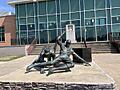
Ty Cobb Statue-Royston Public Library in Royston
-
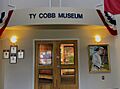
Ty Cobb Museum Entrance in Royston
-
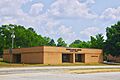
City hall


See also
 In Spanish: Royston (Georgia) para niños
