
National Register of Historic Places listings in Grand Teton National Park facts for kids
Grand Teton National Park in Wyoming is not just famous for its amazing mountains and wildlife. It's also home to many important historical places! These special spots are listed on the National Register of Historic Places. This list helps protect buildings, ranches, and other sites that tell us about the past.
There are 36 places in Grand Teton National Park that are on this important list. Two of them are even more special and are called National Historic Landmarks. These landmarks are recognized for being extra important to the history of the United States.
Contents
What is the National Register of Historic Places?
The National Register of Historic Places is like a special club for historic buildings, sites, and objects in the United States. It's the official list of places that are important to American history, architecture, archaeology, engineering, or culture. When a place is added to this list, it means it's worth preserving for future generations.
Being on the National Register helps protect these places. It also makes them eligible for certain grants or tax benefits that can help with their upkeep. It's a way to celebrate and remember the stories of the past.
Historic Ranches and Lodges
Many of the historic places in Grand Teton National Park are old ranches and lodges. These were often "dude ranches" where visitors could come to experience life in the Old West.
Dude Ranches: A Western Adventure
Dude ranches were popular places for city folks to visit in the early 1900s. They could ride horses, fish, and enjoy the beautiful scenery. Many of these ranches are now protected as historic districts.
- 4 Lazy F Dude Ranch: This ranch was a summer home and a dude ranch. It's also known as Sun Star Ranch.
- AMK Ranch: Another summer home and dude ranch, located near Moran.
- Bar B C Dude Ranch: This was one of the very first and largest dude ranches in the Jackson Hole area.
- Double Diamond Dude Ranch Dining Hall: This building was the main dining hall for a dude ranch. Today, it's part of the Grand Teton Climbers' Ranch.
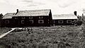
- Hunter Hereford Ranch Historic District: This was once a working ranch in Jackson Hole. It shows what ranch life was like in the past.
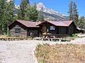
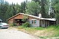
- Ramshorn Dude Ranch Lodge: This lodge was a guest ranch and even a climbing school! Now, the Teton Science School uses it.
- Triangle X Barn: This barn is part of the last dude ranch still operating inside the park. It shows a unique local style of building.
- White Grass Dude Ranch: This ranch is now a center where people learn how to preserve old buildings.
Jackson Lake Lodge: A Modern Landmark

The Jackson Lake Lodge is a very important building. It was designed by a famous architect named Gilbert Stanley Underwood. He created a modern version of a classic lodge. This lodge is so special that it's a National Historic Landmark. It's a great example of how buildings can fit into nature while still being modern.
Murie Ranch: Home of Conservation Heroes

The Murie Ranch Historic District is another National Historic Landmark. This ranch was home to famous conservationists, Olaus Murie and Margaret Murie. They worked hard to protect nature and wildlife. The ranch is also where The Wilderness Society was started. It's a place where important ideas about protecting wild places were born. The Murie Residence itself is also listed, as it was the home of Olaus and Mardie Murie.
Early Homes and Cabins
Before Grand Teton became a national park, people lived and worked on the land. Many of their original homes and cabins are still standing today.
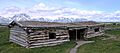
- Andy Chambers Ranch Historic District: This is a nearly complete homestead, showing what a family farm looked like in Jackson Hole.
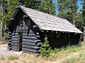
- Cunningham Cabin: This is an early homestead cabin in Jackson Hole. It tells the story of the first settlers in the area.
- Geraldine Lucas Homestead-Fabian Place Historic District: This was the home of an early homesteader. Later, it was connected to the Snake River Land Company, which helped buy land for the park.
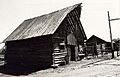
- Manges Cabin: This homestead cabin later became part of a dude ranch.
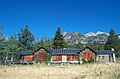
- Mormon Row Historic District: This is a group of homesteads built by Mormon settlers in Jackson Hole. It includes the Andy Chambers Ranch and the famous T. A. Moulton Barn. These buildings are often photographed with the Teton mountains in the background.
Park Service Buildings and Structures
Some historic places were built by the National Park Service or other groups to help manage the park and serve visitors.
- The Brinkerhoff: This was a summer home that was even used as a retreat for presidents!
- Chapel of the Transfiguration: This beautiful chapel was built so that its windows perfectly frame the stunning Cathedral Group of Teton peaks.

- Jackson Lake Ranger Station: This building was first used by the U.S. Forest Service before it became part of the National Park Service.
- Jenny Lake Boat Concession Facilities: These buildings are where visitors can rent boats and enjoy Jenny Lake.
- Jenny Lake CCC Camp NP-4: This is the only remaining building from a Civilian Conservation Corps (CCC) camp in the park. The CCC was a program during the Great Depression that put young men to work building parks and infrastructure.
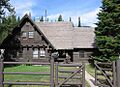
- Jenny Lake Ranger Station Historic District: This ranger station is built in a "rustic" style, designed to blend in with the natural surroundings.
- Kimmel Kabins: These cabins were once a tourist camp.
- Leek's Lodge: Another former tourist camp where visitors could stay.
- Leigh Lake Ranger Patrol Cabin: This is a backcountry ranger station, used by rangers who patrol the more remote areas of the park.
- Menor's Ferry: This was a ferry crossing on the Snake River, operated by an early settler named Bill Menor. It helped people cross the river before bridges were built.

- Moose Entrance Kiosk: This is the entrance structure where visitors pay to enter the park. It's also built in the rustic style.
- Old Administrative Area Historic District: This area used to be the park headquarters. It was built by the CCC.
- Snake River Land Company Residence and Office: This building was once a guest ranch. Later, it became the headquarters for John D. Rockefeller Jr.'s efforts to buy land to expand Grand Teton National Park.
- String Lake Comfort Station: This is a public restroom building, also designed in the rustic style to fit the park's look.
- White Grass Ranger Station Historic District: Another backcountry ranger station.
Backcountry Cabins
Some historic cabins are found deep in the park's backcountry, used by rangers for patrols and shelter.
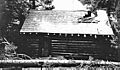
- Cascade Canyon Barn: This barn was used as a backcountry ranger patrol cabin.
- Death Canyon Barn: Another backcountry ranger patrol cabin.
- Moran Bay Patrol Cabin: This cabin was built by the CCC for backcountry patrols.
- Upper Granite Canyon Patrol Cabin: A backcountry patrol cabin located in the southwestern part of the park.
Images for kids
-
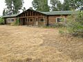
4 Lazy F Dude Ranch Lodge
-
AMK Berol Lodge
-
Bar B C Ranch Main Cabin
-
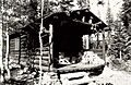
Cascade Canyon Barn
-
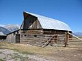
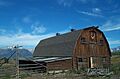
Andy Chambers Ranch Barn
-
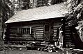
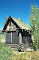
Cunningham Cabin
-
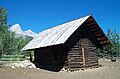
Death Canyon Barn
-
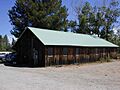
Double Diamond Ranch dining hall
-
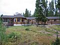
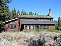
Highlands Dining Room and Lodge
-
Hunter Hereford Barn
-
Jackson Lake Ranger Station
-
Jenny Lake Boathouse
-
Jenny Lake CCC messhall
-
Jenny Lake Ranger Station
-
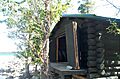
Cabin at Kimmel Kabins
-
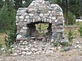
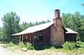
Leek's Lodge chimney
-
Leigh Lake Patrol Cabin
-
Geraldine Lucas cabin
-
Manges Cabin
-
Moose Entrance Kiosk
-
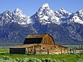
Barns on Mormon Row
-
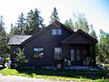
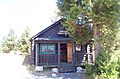
Murie Residence
-
Beaver Creek Superintendent's Residence
-
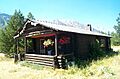
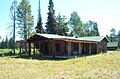
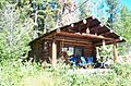
Ramshorn Dude Ranch Lodge
-
Snake River Land Company Office
-
String Lake Comfort Station
-
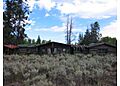
Triangle X Barn
-
White Grass Main Cabin
-
White Grass Ranger Station


