
National Register of Historic Places listings in Greene County, Missouri facts for kids

This article is about the cool, old places in Greene County, Missouri that are listed on the National Register of Historic Places. Think of this register as a special list of buildings, areas, or even battlefields that are really important to the history of the United States. When a place is on this list, it means it's worth protecting and remembering for future generations.
Greene County has many such places! There are 71 different properties and areas that are officially recognized for their historical importance. One place was on the list but has since been removed. These special spots help us learn about the past and see how people lived, worked, and built things long ago.
Contents
- What is the National Register of Historic Places?
- Cool Historic Places in Greene County
- Historic Buildings and Homes
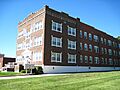
- Abou Ben Adhem Shrine Mosque
- Ambassador Apartments
- Elijah Teague Anderson House
- Camp Manor Apartments
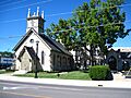
- Christ Episcopal Church
- College Apartments
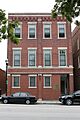
- Day House
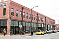
- Fallin Brothers Building
- Finkbiner Building
- Franklin Springfield Motor Co. Building
- Gillioz Theater
- Gottfried Furniture Company Building
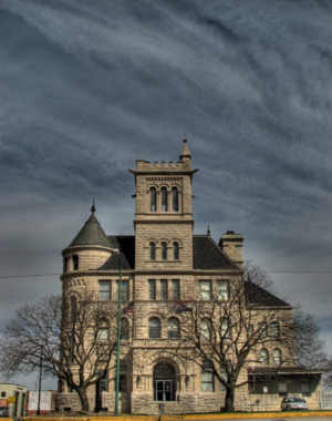
- Greene County Courthouse
- Heer's Department Store
- Holland Building
- Jefferson Street Footbridge
- Keet-McElhany House
- Robert B. and Vitae A. Kite Apartment Building
- Landers Theater
- Marquette Hotel
- Old Calaboose
- Palace Hotel
- Pythian Home of Missouri
- Rail Haven Motel
- Route 66 Steak 'n Shake
- Henry Schneider Building
- Springfield National Cemetery
- Springfield Seed Co. Office and Warehouse
- U.S. Customhouse and Post Office
- E. M. Wilhoit Building
- Edward M. and Della C. Wilhoit House
- Wise Feed Company Building
- Historic Districts
- Campbell Avenue Historic District
- Commercial Street Historic District
- Mid-Town Historic District
- Rock Fountain Court Historic District
- South Avenue Commercial Historic District
- South-McDaniel-Patton Commercial Historic District
- Springfield Public Square Historic District
- Springfield Warehouse and Industrial Historic District
- Walnut Street Commercial Historic District
- Walnut Street Historic District
- West Walnut Street Commercial Historic District
- Woods-Evertz Stove Company Historic District
- Other Important Sites
- Historic Buildings and Homes
- Former Listing
- Images for kids
What is the National Register of Historic Places?
The National Register of Historic Places is the official list of the nation's historic places that are worth saving. It's like a hall of fame for buildings, sites, structures, objects, and districts that have played a big part in American history, architecture, archaeology, engineering, or culture.
Why are places listed?
Places are listed for many reasons. Maybe a famous person lived there, or an important event happened there. Sometimes, a building is listed because it shows a special style of architecture or was built using unique methods. Listing a place helps people understand its value and encourages efforts to keep it safe and sound.
Cool Historic Places in Greene County
Greene County is home to many fascinating historic sites. Let's look at a few examples of the types of places you can find on this special list.
Historic Buildings and Homes
Many buildings in Greene County are on the list because of their unique design or the stories they hold.
Abou Ben Adhem Shrine Mosque

The Abou Ben Adhem Shrine Mosque is a really cool building in Springfield, Missouri. It was built in 1923 and looks like something out of a fairy tale with its unique design. It's located at 601 E. St. Louis and was added to the list in 1982.
Ambassador Apartments

The Ambassador Apartments building, found at 1235 E. Elm St. in Springfield, was added to the list in 2008. It's an example of historic apartment living.
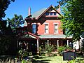
Elijah Teague Anderson House

In Republic, Missouri, you can find the Elijah Teague Anderson House at 406 N. Pine St. This house was recognized in 1980 for its historical importance.
Camp Manor Apartments

Another interesting apartment building, the Camp Manor Apartments at 423 E. Elm St. in Springfield, joined the list in 2005.
Christ Episcopal Church

The Christ Episcopal Church at 601 E. Walnut St. in Springfield is a beautiful church building that was added to the list in 1987.
College Apartments

The College Apartments at 408 E. Walnut St. in Springfield were listed in 2003.
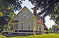
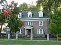
Day House

The Day House at 614 South St. in Springfield is a historic home that was added to the list in 1976.
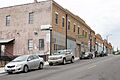
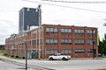
Fallin Brothers Building

The Fallin Brothers Building at 211-229 S. Market Ave. in Springfield was listed in 2012. It's part of a larger group of historic places in Springfield.
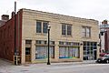
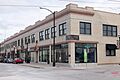
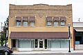
Finkbiner Building

The Finkbiner Building at 509-513 W. Olive St. in Springfield was recognized in 2005.
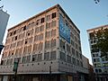
Franklin Springfield Motor Co. Building

The Franklin Springfield Motor Co. Building at 312-314 E. Olive St. in Springfield was added in 2006. It reminds us of the early days of cars!
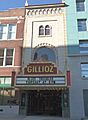
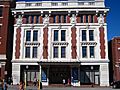
Gillioz Theater

The Gillioz Theater at 325 Park Central E. in Springfield is a grand old theater listed in 1991. Imagine all the shows and movies that have been seen there!
Gottfried Furniture Company Building

The Gottfried Furniture Company Building at 326 Boonville Ave. in Springfield was listed in 2007.
Greene County Courthouse

The Greene County Courthouse at 940 Boonville Ave. in Springfield is where important county decisions are made. It became a historic listing in 2007.
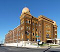
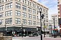
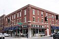
Heer's Department Store

Heer's Department Store at 138 Park Central Square in Springfield was a big shopping spot in its day. It was listed in 2002.
Holland Building

The Holland Building at 205 Park Central East in Springfield was added to the list in 2000.
Jefferson Street Footbridge

The Jefferson Street Footbridge connects Jefferson Ave. between Commercial and Chase Sts. in Springfield. This unique bridge was listed in 2003.
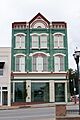
Keet-McElhany House

The Keet-McElhany House at 435 E. Walnut St. in Springfield is another historic home, listed in 1984.
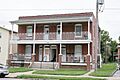
Robert B. and Vitae A. Kite Apartment Building

This apartment building at 769-771 South Ave. in Springfield was listed in 2004.
Landers Theater

The Landers Theater at 311 E. Walnut in Springfield is a very old theater, listed way back in 1977. It's still a popular place for shows today!
Marquette Hotel

The Marquette Hotel at 400 East Walnut in Springfield was listed in 2000.
Old Calaboose

The Old Calaboose at 409 W. McDaniel St. in Springfield is a historic jail building, listed in 1980.
Palace Hotel

The Palace Hotel at 501 College St. in Springfield was listed in 2002.
Pythian Home of Missouri

The Pythian Home of Missouri at 1451 E. Pythian St. in Springfield was listed in 2009. It's a large, impressive building.
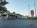
Rail Haven Motel

The Rail Haven Motel at 203 S. Glenstone Ave. in Springfield is famous because it's on the historic Route 66. It was listed in 2010.
Route 66 Steak 'n Shake
The Route 66 Steak 'n Shake at 1158 E. St. Louis St. in Springfield is another cool spot on Route 66, listed in 2012. It's a classic diner!
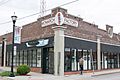
Henry Schneider Building

The Henry Schneider Building at 600 College St.-219-231 S. Main Ave. in Springfield was listed in 2006.
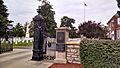
Springfield National Cemetery

The Springfield National Cemetery at 1702 E. Seminole St. in Springfield is a very important place where many veterans are buried. It was listed in 1999.
Springfield Seed Co. Office and Warehouse

The Springfield Seed Co. Office and Warehouse at 319 N. Main Ave. in Springfield was listed in 2006.
U.S. Customhouse and Post Office
The U.S. Customhouse and Post Office at 830 Boonville Ave. in Springfield, now the City Hall, was listed in 1979.
E. M. Wilhoit Building

The E. M. Wilhoit Building at 300-330 E. Pershing St. in Springfield was listed in 2005.
Edward M. and Della C. Wilhoit House

The Edward M. and Della C. Wilhoit House at 903 S. Weller Ave. in Springfield was listed in 2004.
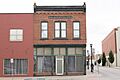
Wise Feed Company Building

The Wise Feed Company Building at 438-440 S. Campbell Ave. in Springfield was listed in 2003.
Historic Districts
Sometimes, not just one building, but a whole area or neighborhood is considered historic. These are called "historic districts."
Campbell Avenue Historic District
The Campbell Avenue Historic District includes parts of S. Campbell Ave. and Park Central West in Springfield. It was listed in 1999 and expanded in 2005.
Commercial Street Historic District
The Commercial Street Historic District in Springfield is a whole street known for its historic buildings and shops. It was listed in 1983.
Mid-Town Historic District
The Mid-Town Historic District in Springfield covers a large area with many historic homes and buildings. It was listed in 1989 and expanded in 2002.
Rock Fountain Court Historic District
The Rock Fountain Court Historic District at 2400 W. College St. in Springfield was listed in 2003.
South Avenue Commercial Historic District
This district includes parts of Walnut and Pershing Sts., and South and Robberson Aves. in Springfield. It was listed in 1999.
South-McDaniel-Patton Commercial Historic District
This district is roughly bounded by S. Campbell Ave., W. McDaniel St., South Ave., and W. Walnut St. in Springfield. It was listed in 2003.
Springfield Public Square Historic District
The Springfield Public Square Historic District covers the heart of downtown Springfield, including Park Central Square. It was listed in 2006 and expanded in 2010.
Springfield Warehouse and Industrial Historic District
This district includes areas around E. Water, W. Mill and W. Phelps Sts. and Boonville Ave. in Springfield. It was listed in 1999.
Walnut Street Commercial Historic District
The Walnut Street Commercial Historic District focuses on Walnut St. in Springfield and was listed in 1999.
Walnut Street Historic District
This larger district covers parts of McDaniel, Walnut, and Elm Sts. and the Sherman Parkway in Springfield. It was listed in 1985 and expanded in 2002.
West Walnut Street Commercial Historic District
This district includes parts of W. Walnut St. and S. Campbell Ave. in Springfield. It was listed in 2002.
Woods-Evertz Stove Company Historic District
This district is bounded by N. Jefferson Ave., E Phelps St., N. Robberson Ave., and E. Tampa St. in Springfield. It was listed in 2003.
Other Important Sites
Not all historic places are buildings. Some are battlefields or other unique sites.
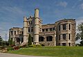
Nathan Boone Homestead State Historic Site
The Nathan Boone House is located north of Ash Grove on Highway V. Nathan Boone was the son of the famous explorer Daniel Boone! This site was listed in 1969.
Wilson's Creek National Battlefield

The Wilson's Creek National Battlefield is southwest of Springfield on Route 174. This is a very important site from the American Civil War. It was listed in 1966 and helps us remember a significant moment in American history.
Former Listing
Sometimes, a place that was once on the National Register might be removed. This usually happens if the building is destroyed or changed so much that it loses its historical importance.
Second Baptist Church
The Second Baptist Church at 729 North Washington in Springfield was listed in 2000 but was removed in 2001.
Images for kids
-
The beautiful Abou Ben Adhem Shrine Mosque.
-
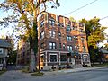
The Ambassador Apartments building.
-
The historic Elijah Teague Anderson House.
-
The Camp Manor Apartments.
-
Christ Episcopal Church in Springfield.
-
The College Apartments building.
-

The Day House, a historic home.
-
The Fallin Brothers Building.
-
The Finkbiner Building, now Olive Place Lofts.
-
The Franklin Springfield Motor Co. Building.
-
The historic Gillioz Theater.
-
The Gottfried Furniture Company Building.
-

The Greene County Courthouse.
-
Heer's Department Store building.
-
The Holland Building.
-

The Jefferson Street Footbridge.
-
The Keet-McElhany House.
-
The Robert B. and Vitae A. Kite Apartment Building.
-
The Landers Theater.
-
The Marquette Hotel building.
-
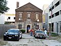
The Old Calaboose.
-
The Palace Hotel.
-
The Pythian Home of Missouri.
-
The historic Rail Haven Motel.
-
The Henry Schneider Building, now Monarch Art Factory.
-
The main gate of Springfield National Cemetery.
-
The Springfield Seed Co. Office and Warehouse.
-

The U.S. Customhouse and Post Office, now Springfield City Hall.
-
The E. M. Wilhoit Building.
-
The Edward M. and Della C. Wilhoit House.
-
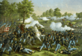
A painting of the Battle of Wilson's Creek.
-
The Wise Feed Company Building.
