
National Register of Historic Places listings in Greenwood County, South Carolina facts for kids

Have you ever wondered about old buildings and places that are super important to history? Well, in Greenwood County, South Carolina, there's a special list of these amazing spots! It's called the National Register of Historic Places.
This list helps protect places that tell us stories about the past. It includes buildings, sites, and even whole neighborhoods that are important for their history, architecture, or what happened there. In Greenwood County, there are 21 places on this list, and one of them is even a National Historic Landmark – that's like a super important historic place!
Greenwood County's Historic Treasures
Let's explore some of the cool historic places you can find in Greenwood County. Each one has a story to tell about the past!
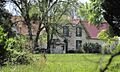
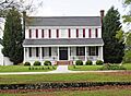
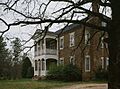
- Barratt House
* Located near Greenwood. * This historic house was added to the list on September 12, 1985.
- J. Wesley Brooks House
* You can find this house south of Greenwood. * It became a historic site on March 30, 1973.
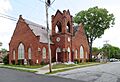
- Greenville Presbyterian Church
* This church is in Donalds. * It joined the list on May 20, 1998.
- Kinard House
* Located in Ninety Six. * This house was recognized on March 7, 2007.
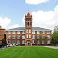
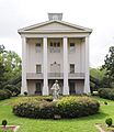
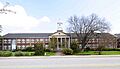
- Lander College Old Main Building
* This important building is at Lander University in Greenwood. * It was added to the list on August 2, 1984.
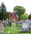
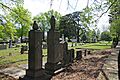
- Magnolia Cemetery
* This historic cemetery is in Greenwood. * It became a listed site on June 9, 2004.
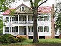
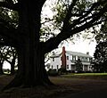
- Moore-Kinard House
* You can find this house near Ninety Six. * It was recognized on August 4, 1983.
- Mt. Pisgah A.M.E. Church
* This church is in Greenwood. * It joined the list on August 16, 1979.
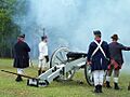
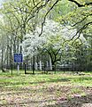
- Ninety Six National Historic Site
* This is a very special place south of Ninety Six. * It's a National Historic Landmark and was listed on December 3, 1969. It played a big role in the American Revolutionary War.
- The Oaks
* This historic property is near Coronaca. * It was added to the list on December 17, 2010.
- Old Cokesbury and Masonic Female College and Conference School
* This historic school is north of Greenwood in Cokesbury. * It was recognized on August 25, 1970.
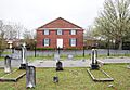
- Old Greenwood Cemetery
* This historic cemetery is in Greenwood. * It joined the list on March 1, 2002.
- Old Greenwood High School
* This former school building is in Greenwood. * It was added to the list on October 10, 1985.
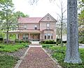
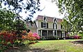
- James C. Self House
* This house is located in Greenwood. * It became a historic site on November 20, 1987.
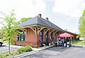
- Southern Railway Depot
* This old train station is in Ninety Six. * It was recognized on October 6, 2011.
- Stony Point
* This historic site is north of Greenwood. * It was added to the list on June 20, 1975.
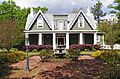
- Sunnyside
* This historic home is in Greenwood. * It joined the list on November 14, 1978.
- Tabernacle Cemetery
* This cemetery is near Greenwood. * It was recognized on August 1, 2008.
- Trapp and Chandler Pottery Site (38GN169)
* This important archaeological site is near Kirksey. * It was added to the list on January 6, 1986. Its exact location is kept private to protect it.
- Vance-Maxwell House
* This house is in Greenwood. * It became a historic site on March 5, 1982.
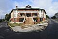
- Ware Shoals Inn
* This historic inn is in Ware Shoals. * It was recognized on November 1, 2007.
Former Listing
Sometimes, a place might be removed from the National Register of Historic Places. This usually happens if it's moved or if it changes too much.
- Benjamin Mays Birthplace
* This was the birthplace of Benjamin Mays, a very important leader in education and civil rights. * It was originally listed on May 18, 1998. * It was removed from the list on December 8, 2005, because it was moved to Greenwood.
Images for kids
-
Barratt House
-
J. Wesley Brooks House
-
Greenville Presbyterian Church
-
Kinard House
-
Lander College Old Main Building
-
Magnolia Cemetery
-
Moore-Kinard House
-
Mt. Pisgah A.M.E. Church
-
Ninety Six National Historic Site
-
The Oaks
-
Old Cokesbury and Masonic Female College and Conference School
-
Old Greenwood Cemetery
-
Old Greenwood High School
-
Southern Railway Depot
-
Stony Point
-
Sunnyside
-
Tabernacle Cemetery
-

Trapp and Chandler Pottery Site (38GN169)
-
Vance-Maxwell House
-
Ware Shoals Inn


.jpg)


