
National Register of Historic Places listings in Grenada County, Mississippi facts for kids

This page lists special places in Grenada County, Mississippi, that are part of the National Register of Historic Places. Think of it like a national list of important buildings, sites, and objects that tell a story about America's past.
These places are chosen because they are historically or architecturally important. When a place is on this list, it means it's recognized as a valuable part of our country's history. There are 16 such places in Grenada County.
What is the National Register of Historic Places?
The National Register of Historic Places is the official list of the United States' historic places worth saving. It's managed by the National Park Service. Being on this list helps protect these places and makes people more aware of their importance.
Why are places added to the Register?
Places are added to the Register for many reasons. They might be important because of:
- Events that happened there, like battles or important meetings.
- Famous people who lived or worked there.
- Their unique design or how they were built.
- What they tell us about a certain time period or way of life.
Historic Places in Grenada County
Grenada County has many interesting places that are part of the National Register. These sites include old battlegrounds, grand homes, and important buildings that show the county's rich history.
Confederate Earthworks
The Confederate Earthworks are old military defenses built during the American Civil War. They are located west of Grenada. These earthworks were part of the defenses used by the Confederate army. They show how soldiers protected areas during the war.
Confederate Redoubt
Another Civil War site is the Confederate Redoubt on Springhill Road. A redoubt is a small fort or defensive position. This site also played a role in the Civil War history of Grenada.
Evergreen Plantation
Evergreen Plantation is a historic property located north of Grenada. Plantations were large farms, especially common in the Southern United States before the Civil War. This plantation is recognized for its historical significance.
Glenwild Plantation Manager's House
The Glenwild Plantation Manager's House is another building from a plantation. It was where the manager of the Glenwild Plantation lived. This house gives us a glimpse into the daily life and operations of these large farms.

Grenada Bank
The Grenada Bank building, located on 1st Street, is an important part of the city's downtown. It was built in 1978 and is recognized for its architecture and role in the community's financial history.

Grenada Downtown Historic District
The Grenada Downtown Historic District includes a large area of the city center. This district is special because it has many historic buildings close together. Walking through this area is like stepping back in time, seeing how the city looked years ago.
Grenada Masonic Temple
The Grenada Masonic Temple is a building used by the Masons, a fraternal organization. Located on South Main Street, this temple is recognized for its architectural style and its place in the community's social history.
Illinois Central Depot
The Illinois Central Depot was a train station. Train depots were very important for travel and trade in the past. This depot in Grenada served the Illinois Central Railroad and is a reminder of the age of trains.

Lee-Dubard House
The Lee-Dubard House is a historic home on 3rd Street. Many old homes are listed on the National Register because of their unique design or the families who lived there. This house is a good example of historic residential architecture in Grenada.
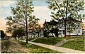
Margin Street Historic District
The Margin Street Historic District is another area with many historic buildings. It includes Margin Street and parts of Line Street. Like the Downtown Historic District, it shows the historic layout and architecture of Grenada's neighborhoods.

Odd Fellows and Confederate Cemetery
The Odd Fellows and Confederate Cemetery is a historic burial ground. It includes graves of members of the Independent Order of Odd Fellows, another fraternal organization, and soldiers from the Confederate army. Cemeteries can be historic sites because they tell us about the people and events of the past.
Providence Cemetery
The Providence Cemetery is another historic cemetery located east of Grenada. It is recognized for its historical importance as a burial site for early residents of the area.
South Main Historic District
The South Main Historic District covers a section of South Main Street. This district is known for its collection of historic buildings, including homes and businesses, that show the development of Grenada over time.

US Post Office-Grenada
The US Post Office-Grenada building is a historic post office. Post offices were central to communication and community life. This building is recognized for its architecture and its role in serving the people of Grenada.
Sen. Edward C. Walthall House
The Sen. Edward C. Walthall House was the home of Edward C. Walthall, a notable politician who served as a United States Senator from Mississippi. This house is important because of its connection to a significant historical figure.
Wild Wings Mounds (22Gr713)
The Wild Wings Mounds are ancient earth mounds. These mounds were often built by Native American cultures for various purposes, such as burials or ceremonial sites. They are very important for understanding the early history of the region.
Images for kids
-
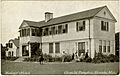
Glenwild Plantation Manager's House
-
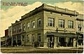
Grenada Bank building
-
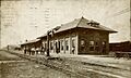
Illinois Central Depot
-
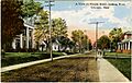
Margin Street Historic District
-
South Main Historic District
