
National Register of Historic Places listings in Grundy County, Tennessee facts for kids

Have you ever wondered what makes a building or a place super special and worth protecting? In Grundy County, Tennessee, there are many amazing spots that are so important, they're listed on something called the National Register of Historic Places. This is a special list kept by the United States government. It helps make sure that important buildings, areas, and sites from the past are kept safe and preserved for future generations.
This article will tell you about the cool historic places in Grundy County that are on this list. There are 22 places currently listed. Four other places were once on the list but have since been removed.
Some places, like parts of Monteagle, Tennessee, are also listed in Marion County, Tennessee, because the city is in both counties.
Cool Historic Places in Grundy County
Here are some of the interesting places in Grundy County that are recognized for their history and importance:
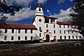
Beersheba Springs Historic District
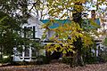
The Beersheba Springs Historic District is a whole area listed on the Register. It includes the old Beersheba Springs Hotel and many other buildings. This area was a popular resort in the late 1800s and early 1900s. It was added to the list on March 20, 1980.
Christ Episcopal Church
Located in Tracy City, Tennessee, the Christ Episcopal Church is a beautiful historic church. You can find it at 530 10th Street. It was added to the National Register on April 24, 2015.
Coalmont Bank Building
The Coalmont Bank Building is in Coalmont, Tennessee. It stands at the corner of State Route 56 and Heidenburg Street. This building became a historic site on March 14, 1991.
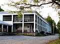
DuBose Memorial Church Training School
In Monteagle, Tennessee, you'll find the DuBose Memorial Church Training School. It's located at Fairmont and College Streets. This school was added to the Register on November 25, 1980.
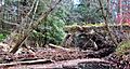
Firescald Creek Stone Arch Bridge
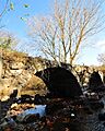
This old stone bridge crosses Firescald Creek on Northcutts Cove Road near Altamont, Tennessee. It's a cool example of old bridge building. It was listed on April 1, 1987.
Grundy Lakes Historic District
The Grundy Lakes Historic District is another important area. It's part of Grundy Lakes State Park, east of State Route 56 in Tracy City, Tennessee. This district was recognized on April 1, 1987.
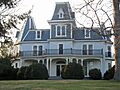
E.L. Hampton House
The E.L. Hampton House is a historic home in Tracy City, Tennessee. It's located at Depot and Oak Street. This house joined the list of historic places on April 1, 1987.
Hickory Creek Stone Arch Bridge
Another stone arch bridge, this one crosses Hickory Creek on Sherwood Road near Marvin Chapel, Tennessee. It's a neat piece of history and was listed on April 1, 1987.
Marugg Company
The Marugg Company building is at 35 Depot Street in Tracy City, Tennessee. This site was added to the National Register on April 1, 1987.
Monteagle Sunday School Assembly Historic District
This large historic district in Monteagle, Tennessee, is off U.S. Route 41, U.S. Route 64, and State Route 56. It's a unique place with a long history of education and community. It was listed on March 25, 1982.
H.B. Northcutt House
The H.B. Northcutt House is on State Route 56 in Altamont, Tennessee. This historic home was added to the Register on March 23, 1982.
Northcutts Cove Chapel
Southeast of Altamont, Tennessee, you'll find the Northcutts Cove Chapel. This charming chapel became a historic listing on April 18, 1979.
John E. Patton House
The John E. Patton House is on Roddy Creek Road in Coalmont, Tennessee. This house was recognized as a historic place on April 1, 1987.
Scott Creek Stone Arch Bridge
This stone arch bridge goes over Scott Creek at Flat Branch Road in Coalmont, Tennessee. It's another example of the area's historic bridges. It was listed on April 1, 1987.
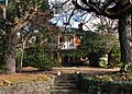
Col. A.M. Shook House
The Col. A.M. Shook House is in Tracy City, Tennessee, at the corner of Depot and Montgomery Streets. This important house was added to the Register on April 1, 1987.
Stagecoach Inn (Gruetli, Tennessee)
The Stagecoach Inn is on Colony Road in Gruetli, Tennessee. This old inn was a stop for travelers in the past. It was listed on April 2, 1987.
Stagecoach Road
Part of the Savage Gulf State Natural Area, the Stagecoach Road is northwest of State Route 108 near Beersheba Springs, Tennessee. This historic road was added to the Register on April 1, 1987.
Stoker-Stampfli Farm
The Stoker-Stampfli Farm is on Colony Cemetery Road in Gruetli, Tennessee. This historic farm was recognized on April 2, 1987.
Tracy City Coke Ovens
The Tracy City Coke Ovens are west of Hobbs Hill Road in Tracy City, Tennessee. These ovens were used to make coke, an important fuel for industry. They were listed on April 1, 1987.
Frank White House
The Frank White House is on 10th Street in Tracy City, Tennessee. This historic home was added to the National Register on April 1, 1987.
Wonder Cave Historic District
The Wonder Cave Historic District is on Wonder Cave Road in Monteagle, Tennessee. This area, including the famous Wonder Cave, was listed on April 1, 1987.
L.V. Woodlee House
The L.V. Woodlee House is on Cumberland Street in Altamont, Tennessee. This house became a historic listing on April 2, 1987.
Wrenn's Nest
The Wrenn's Nest is on Eagle Cliff Road in Monteagle, Tennessee. This interesting place was added to the National Register on March 13, 1986.
Former Historic Listings
Sometimes, a place is removed from the National Register. This can happen if the building is changed too much, or if it is torn down. Here are some places that were once listed in Grundy County:
- Elkhead Stone Arch Bridge: This bridge was north of Pelham, Tennessee. It was listed in 1978 but removed in 1986.
- Grundy County Jail: This red brick building was a local landmark in Altamont, Tennessee. It was listed in 1978 but was torn down in 1982.
- Miner's Hall: Located on Jasper Road in Tracy City, Tennessee, this hall was listed in 1987 but removed in 1988.
Images for kids
-
The Beersheba Springs Hotel complex.
-
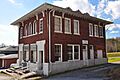
The Coalmont Bank Building.
-
The DuBose Memorial Church Training School.
-
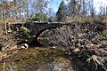
The Firescald Creek Stone Arch Bridge.
-
The E.L. Hampton House.
-
The Hickory Creek Stone Arch Bridge.
-
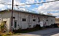
The Marugg Company building.
-
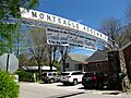
The entrance to the Monteagle Sunday School Assembly Historic District.
-
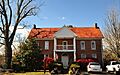
The H.B. Northcutt House.
-
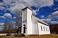
The Northcutts Cove Chapel.
-
The Scott Creek Stone Arch Bridge.
-
The Col. A.M. Shook House.
-
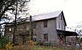
The Stagecoach Inn in Gruetli.
-
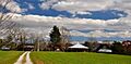
The Stoker-Stampfli Farm.
-
The Frank White House.
-

The L.V. Woodlee House.


