
National Register of Historic Places listings in Henderson County, Kentucky facts for kids

This article is about the amazing historic places in Henderson County, Kentucky, that are listed on the National Register of Historic Places. Think of the National Register as a special list of buildings, sites, and objects that are important to American history, architecture, archaeology, engineering, or culture. When a place is on this list, it means it's recognized for its special value and efforts are made to protect it.
In Henderson County, there are 27 places on this list. Four of these are part of an even bigger, super-important site called a National Historic Landmark, which stretches across several counties. One place was once on the list but has since been removed. Let's explore some of these cool historic spots!
Contents
What is the National Register of Historic Places?
The National Register of Historic Places is the official list of the nation's historic places worth saving. It's like a hall of fame for buildings, neighborhoods, and archaeological sites. Being on the list helps people understand why these places are important. It also encourages communities to protect them for future generations.
Historic Places in Henderson County
Henderson County has many interesting places that tell stories about its past. These include old houses, schools, parks, and even ancient archaeological sites.
Special Buildings and Areas
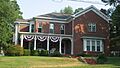
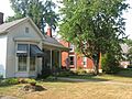
- Alves Historic District: This is a whole neighborhood in Henderson, Kentucky, with many historic buildings. It's bounded by streets like Green, Center, and Washington.
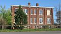
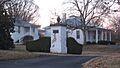
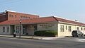
- Audubon School: Located at 1400 Clay Street in Henderson, this school building has been recognized for its history.
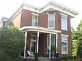
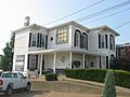
- Barret House: You can find this historic house at 204 South Elm Street in Henderson.
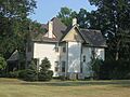
- Barret-Keach Farm: This old farm is located at 1586 Kentucky Route 136 West in Henderson.
- Delano-Alves House: Another historic home, this one is at 536 Chestnut Street in Henderson.
- E.L. Ehlen Livery and Sale Stable: This building at 110 1st Street in Henderson was once a stable where horses were kept and sold.
- Geibel House: This house at 327 North Main Street in Henderson is also on the list.
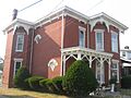
- J. Hawkins Hart House: Located at 630 Center Street in Henderson, this house was designed by a famous architect named George Franklin Barber.
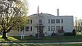
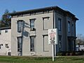
- Henderson Armory: The armory, at 735 North Elm Street in Henderson, is a historic building that was likely used for military training or storage.
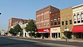
- Henderson Commercial District: This district includes many historic businesses and buildings in downtown Henderson, roughly around Main, 3rd, Elm, and 1st Streets.
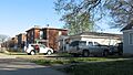
- Henderson Cotton Mill Workers Housing District: This area in Henderson, near Washington and Letcher Streets, includes homes where cotton mill workers used to live.
- Henderson Louisville and Nashville Railroad Depot: This old train station at 300 Clark Street in Henderson is a reminder of the importance of railroads in the past.
- Jackson-Ijames Farm: Also known as "Tallmadge," this farm is located at 12500 South Kentucky Route 1078 in Henderson.
- Klee Funeral Parlor: This historic building at 13-17 South Main Street in Henderson was once a funeral home.
- John E. McCallister House: You can find this house at 839 North Green Street in Henderson.
- North Main Street Historic District: This district covers North Main Street from 5th to 8th Streets in Henderson and has many historic buildings.
- John O'Byrne House: This house at 317 North Main Street in Henderson is another historic home.
- Prichett House: Located at 311 North Main Street in Henderson, this is another historic residence.
- St. Paul's Episcopal Church: This beautiful church at 338 Center Street in Henderson is also on the list.
- William Soaper Farm: This farm at 2323 Zion Road in Henderson is recognized for its historical significance.
- South Main and South Elm Streets Historic District: This large historic area in Henderson includes parts of Washington, Center, South Green, Jefferson, South Main, and Water Streets.
- Stewart House: This house at 827 South Green Street in Henderson is also a protected historic site.
Important Natural and Archaeological Sites
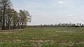
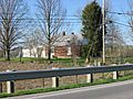
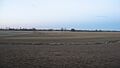
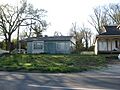
- Archaeological Site KHC-3 (15HE635): This ancient site is found in the lawn of a house near Reed Bluff City Road, northeast of Bluff City. It's part of the Green River Shell Middens Archeological District. A "shell midden" is a mound of shells and other debris left behind by ancient people who ate a lot of shellfish.
- Archaeological Site KHC-4 (15HE580): This site is on the right bank of the Green River, about one mile above Bluff City. It's also part of the Green River Shell Middens Archeological District.
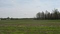
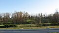
- Bluff City Shell Mound (15HE160): This shell mound is about half a mile above Bluff City on a bluff overlooking the Green River. It's another important part of the Green River Shell Middens Archeological District.
- James Giles Shell Midden (15HE589): This site is on the left bank of the Green River, east of Bluff City. It's also part of the Green River Shell Middens Archeological District. These sites help us learn about the lives of people who lived here thousands of years ago.
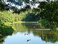
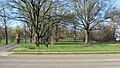
- John James Audubon State Park: This beautiful park, located on U.S. Route 41 in Henderson, is named after the famous bird artist John James Audubon. It's recognized for its natural beauty and connection to Audubon.
Places That Were Once Listed
Sometimes, a place might be removed from the National Register. This can happen if the building is changed too much, or if it's destroyed.
- Douglass High School: This school, located at 300 South Alvasia Street in Henderson, was listed in 1980 but was removed from the list in 1988.
Images for kids
-

Alves Historic District
-
Archaeological Site KHC-3
-
Archaeological Site KHC-4
-
Audubon School
-
John James Audubon State Park
-
Barret House
-
Barret-Keach Farm
-
Bluff City Shell Mound
-
Delano-Alves House
-
E.L. Ehlen Livery and Sale Stable
-
Geibel House
-
J. Hawkins Hart House
-
Henderson Armory
-
Henderson Commercial District
-
Henderson Cotton Mill Workers Housing District
-

Henderson Louisville and Nashville Railroad Depot
-
Jackson-Ijames Farm
-
James Giles Shell Midden
-

Klee Funeral Parlor
-
John E. McCallister House
-

North Main Street Historic District
-
John O'Byrne House
-
Prichett House
-

St. Paul's Episcopal Church
-
William Soaper Farm
-
South Main and South Elm Streets Historic District
-
Stewart House


