
National Register of Historic Places listings in Huron County, Michigan facts for kids
This article is about special places in Huron County, Michigan that are listed on the National Register of Historic Places. These places are important because they tell us about the history of the area. They could be old buildings, special areas, or even lighthouses! The National Register helps protect these places so people can learn from them for many years to come.
Cool Historic Places in Huron County
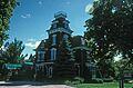
Grice House Museum
The Grice House Museum is a cool place to visit in Harbor Beach, Michigan. It's an old house that was built a long time ago. Now, it's a museum where you can learn about how people lived in the past. It was added to the National Register of Historic Places on November 12, 1982.

Harbor Beach Lighthouse
The Harbor Beach Light is a lighthouse located in Harbor Beach, Michigan. Lighthouses are tall towers with bright lights that help guide ships safely. This one is out on the breakwater, which is like a wall built in the water. It became a historic place on August 4, 1983.

Pointe Aux Barques Lighthouse
Another amazing lighthouse in Huron County is the Pointe aux Barques Light. It's located east of Huron City, Michigan. This lighthouse has been helping sailors for a very long time. It was added to the National Register on March 20, 1973.

Port Austin Reef Light
The Port Austin Light is a lighthouse that stands on the Port Austin Reef, about 2.5 miles north of Port Austin, Michigan. It's out in the water, helping boats navigate the Great Lakes. This lighthouse was recognized as a historic place on September 15, 2011.

Frank Murphy's Birthplace
Did you know a very important person was born in Harbor Beach, Michigan? Frank Murphy was born here! He grew up to be a judge on the highest court in the United States, the Supreme Court. He also served as the Governor of Michigan. His birthplace became a historic site on September 22, 1971.
Historic Districts to Explore
Some areas are special because they have many old buildings or tell a story about a whole community. These are called "historic districts."
Bay Port Fishing History
The Bay Port Historic Commercial Fishing District in Bay Port, Michigan is one such place. It shows how important fishing was to the people who lived here. It became a historic district on September 22, 1977.
Grindstone City's Past
Grindstone City Historic District in Grindstone City is another interesting district. This area was once famous for making grindstones, which are big stones used to sharpen tools. It was added to the National Register on September 3, 1971.
Huron City's Pioneer Life
The Huron City Historic District in Huron City gives us a peek into pioneer life. It's like stepping back in time to see how early settlers lived. This district was listed on April 28, 1995.
Other Notable Buildings
Charles G. Learned House
The Charles G. Learned House is a historic home located in Port Austin, Michigan. It was added to the National Register on May 31, 1984.

Smith-Culhane House
Another historic house in Port Austin, Michigan is the Smith-Culhane House. It was recognized as a historic place on September 24, 2001.

Masonic Temple in Port Hope
The Masonic Temple in Port Hope, Michigan is an old building that was used by a group called the Masons. It was added to the National Register on November 20, 1987.

Winsor and Snover Bank Building
The Winsor and Snover Bank Building in Port Austin, Michigan is an old bank building. It tells us about the history of money and business in the area. It became a historic place on March 19, 1987.

Images for kids
-
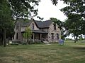
The Grice House Museum in Harbor Beach.
-
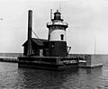
The Harbor Beach Lighthouse standing tall.
-
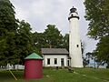
The Pointe Aux Barques Lighthouse and its oil house.
-
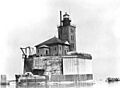
The Port Austin Reef Light out in the water.
-
The Charles G. Learned House.
-
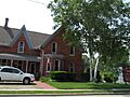
The Smith-Culhane House.
-
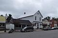
The Masonic Temple in Port Hope.
-
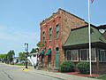
The Winsor and Snover Bank Building.
