Pointe aux Barques Light facts for kids
| Location | Port Hope, Michigan |
|---|---|
| Coordinates | 44°01′24″N 82°47′36″W / 44.02333°N 82.79333°W |
| Year first constructed | 1847 (original tower); 1857 (current tower) |
| Year first lit | 1848 (original light); 1857 (current light) |
| Automated | 1958 |
| Foundation | Dressed stone and timber |
| Construction | Milwaukee Cream City brick |
| Tower shape | Conical |
| Markings / pattern | White with black and red trim |
| Height | 89 feet (27 m) |
| Focal height | 93 feet (28 m) |
| Original lens | Lewis Patent Lamp with reflector and lens (1848–1873); Third order Fresnel lens with bullseyes (1873–1969) |
| Range | 28 nautical miles (52 km; 32 mi) |
| Characteristic | 0.2s fl 4.8s ec.
0.2s fl 14.8s ec. |
The Pointe aux Barques Lighthouse (pronounced "point-uh-BARKS") is an important lighthouse and museum in Huron County, Michigan. It stands on the edge of Lake Huron, at the tip of a region shaped like a thumb. This lighthouse, built in 1857, is one of Michigan's oldest active lighthouses. Today, it helps people learn about the lighthouse, the nearby United States Life-Saving Service station, and local history. The name "Pointe aux Barques" comes from French and means "point of little boats." This name describes the shallow waters that were dangerous for larger ships.
Contents
History of the Pointe aux Barques Lighthouse
In the mid-1800s, most people traveled by sailing ships. There were very few roads, and only a few steamships on the Great Lakes. Ships would follow the coastline. When they needed to cross a large area of water, they used tools like a compass to find their way.

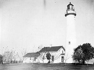
An old photo of the Pointe aux Barques Lighthouse from the USCG.
|
Sailing ships leaving Detroit and the St. Clair River would soon lose sight of the Fort Gratiot Light. This light was built in 1825. The next lighthouse north was at Thunder Bay Island, over 150 miles away. Ships sailing up the Lake Huron coast often ran into trouble near Pointe aux Barques. A dangerous reef, covered by only about two feet of water, stretched almost two miles into Lake Huron.
Pointe aux Barques was also a key turning point for ships heading to the Saginaw River. A lighthouse was built at the mouth of the Saginaw River in 1841. But ships still needed to avoid the reef at Pointe aux Barques to reach Saginaw Bay safely.
Building the First Lighthouse
President James K. Polk approved $5,000 to build the first lighthouse on July 3, 1847. This first lighthouse had a 65-foot tall tower. It was separate from the keeper's house, which was made of local stone.
The first lighthouse keeper, Peter Shook, and his family moved in during 1848. Sadly, Peter Shook drowned while getting supplies in his first year. He was the first Michigan lighthouse keeper to die while working. His wife, Catherine Shook, then became Michigan's first female lighthouse keeper. The keeper's house burned down soon after she took over. However, it was rebuilt, and Catherine continued as keeper for another season. Eight more keepers worked there until the light became fully automatic.
The Current Lighthouse Tower
The first tower and keeper's house became very old and worn out by the 1850s. So, a new tower was built. This one was attached to the keeper's house and made of special Milwaukee Cream City brick. The lighthouse you see today was built in 1857. It is a white tower, 89 feet tall. Its light shines from 93 feet above Lake Huron.
A special spinning lens, called a Third Order Fresnel lens, made the light flash every five seconds. This flash could be seen up to 16 nautical miles away on the lake. Even with the new, taller light, shipwrecks still happened. Because of this, a United States Life-Saving Service station was built near the lighthouse in 1876.
Upgrades and Automation
An assistant keeper's house was added in 1908. The light itself was improved in 1914 with a brighter lamp. This change made the light visible up to 18 nautical miles away. More safety was added in 1918 with a lighted bell buoy. This buoy was placed about two and a quarter miles offshore at the end of the point.
Electricity came to Pointe aux Barques in 1932. A 500-watt light bulb was put into the Third Order lens. The Coast Guard took over responsibility for navigation aids in 1939. This led to the lighthouse becoming fully automatic. Around 1950, the old Fresnel lens was removed. It was replaced with powerful spinning DCB-224 aero beacons. These new lights were rated at 1,000,000 candlepower.
Michigan Historical Marker at the Lighthouse
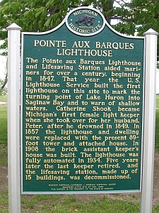
On August 5, 2007, a special Michigan Historical Marker was placed at the lighthouse. Cindy Krueger, whose great-great-great-grandparents were Peter and Catherine Shook, helped present the marker.
The State Historic Preservation Office helps protect old buildings. They gave a $31,000 grant to the county for lighthouse restoration. This money came from selling "Save our Lights" license plates. The county also received another $70,000 grant for restoration work.
The Michigan Historical Marker Program started in 1955. Since then, over 1,500 markers have been placed across the state. These markers are paid for by donations from groups who apply for them. The Michigan Historical Commission decides where the markers go and what they say. The Pointe Aux Barques Lighthouse Society donated $2,875 for this marker.
The words on the historical marker read:
Pointe aux Barques Lighthouse
The Pointe aux Barques Lighthouse and Lifesaving Station aided mariners for over a century, beginning in 1847. That year the U.S. Lighthouse Service built the first lighthouse on this site to mark the turning point of Lake Huron into Saginaw Bay and to warn of shallow waters. Catherine Shook became Michigan’s first female light keeper when she took over for her husband, Peter, after he drowned in 1849. In 1857, the lighthouse and dwelling were replaced with the present 89-foot tower and attached house. In 1908, the brick assistant keeper’s house was built. The lighthouse was fully automated in 1934. Five years later, the last keeper retired, and the lifesaving station, made up of 15 buildings, was decommissioned.
Pointe aux Barques Today
After the lighthouse became automatic, the grounds were given to Huron County. This happened in June 2003. The 1857 tower and the keeper's house are still there. Also remaining are the 1908 assistant keeper's house, an 1892 oil house, and a 1908 outhouse.
The keeper's house is now a museum. One room shows items about the lighthouse's history and its keepers. Many original papers and photos are on display. The lighthouse's original Third Order Fresnel lens is back at the museum. Another room tells the stories of the many shipwrecks in the local waters. The lighthouse tower is still active. It is open to the public only a few times each year.
In late 2017, two buildings from the Life-Saving Service were moved. They now sit about 100 feet from the lighthouse. These buildings were originally built along the shore. They were moved to the Huron City Historic District in 1964.
A campground was built near the lighthouse. This is where the 1876 United States Life-Saving Service (USLSS) station used to be.
In 2003, students from Western Michigan University did an archeological dig at the site. They found proof of an 1840s lighthouse structure. This structure was there before the 1857 building.
The lighthouse was added to the National Register of Historic Places in 1972. It was repaired a lot in 2005. In 2008, a project to restore the outside of the lighthouse was finished.
The Pointe aux Barques Maritime Museum Society (PaBMMS) works to protect and restore the lighthouse and museum. It was started in 2002.
Visiting the Lighthouse
The lighthouse is located off M-25. It is about 7 miles north of Port Hope. It is also 11 miles south of Port Austin on Lighthouse Road. Visitors can spend a good part of a day exploring the lighthouse grounds and museum. They can also enjoy the beautiful shore of Lake Huron.
See also
- Great Lakes Storm of 1913
- Lighthouses in the United States
- The Michigan Historical Marker Web Site
- Port Hope's Pointe aux Barques Lighthouse to Receive Michigan Historical Marker Aug. 5
- National Restoration, Inc.
- Shipwrecks of the 1913 Great Lakes storm
 | Jackie Robinson |
 | Jack Johnson |
 | Althea Gibson |
 | Arthur Ashe |
 | Muhammad Ali |


