
National Register of Historic Places listings in Kalamazoo County, Michigan facts for kids
The National Register of Historic Places is like a special list of important buildings, places, and objects in the United States. These places are chosen because they tell us a lot about American history, architecture, archaeology, engineering, or culture. When a place is added to this list, it means it's recognized as something valuable that should be protected and remembered for future generations.
In Kalamazoo County, Michigan, there are many fascinating places on this list. They include old homes, important public buildings, and even entire neighborhoods! Each one has a unique story that helps us understand the past of Kalamazoo and the people who lived there.
| Top - 0-9 A B C D E F G H I J K L M N O P Q R S T U V W X Y Z |
What are Historic Places?
Imagine a building that has stood for over a hundred years, seen many changes, and holds countless stories within its walls. That's often what a historic place is! The National Register of Historic Places is the official list of the nation's historic places worth saving. It's managed by the National Park Service.
When a place is listed, it gets special recognition. This can help protect it from being torn down or changed too much. It also helps people learn about and appreciate the history around them. These places are like time capsules, showing us how people lived, worked, and built things long ago.
Exploring Kalamazoo's Historic Gems
Kalamazoo County is full of amazing historic sites. Let's take a look at some of them!
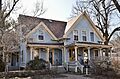
Homes with History
Many old houses in Kalamazoo County are on the National Register. These homes often show us different styles of architecture from the past.
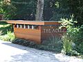
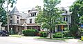
The Acres

Located in Charleston Township, The Acres is more than just one house; it's a historic district. It includes several properties at different addresses on Hawthorne Drive. It was added to the list in 2004.
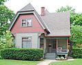
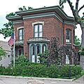
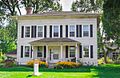
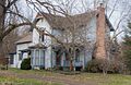
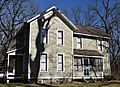
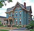
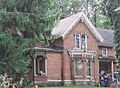
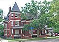
Peter B. Appeldorn House
The Peter B. Appeldorn House is found at 532 Village Street in Kalamazoo. This house became a historic place in 1983.
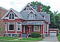
Eric and Margaret Ann Brown House

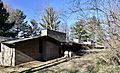
The Eric and Margaret Ann (Davis) Brown House is a more recent addition to the list, added in 2016. It's located at 2806 Taliesin Drive in Kalamazoo.
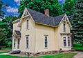
Isaac Brown House
Another historic home in Kalamazoo is the Isaac Brown House at 427 S. Burdick Street. It was listed in 1983.
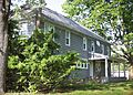
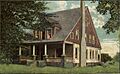
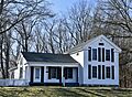
William S. Delano House
The William S. Delano House is part of what was once Delano Farms. You can find it north of Kalamazoo at 555 W. E Avenue. It was added to the list in 1979.
Benjamin and Maria Drake Farm

The Benjamin and Maria (Ogden) Drake Farm is another farmstead on the list. It's at 927 N. Drake Road in Kalamazoo and was recognized in 2012.
John Gibbs House
The John Gibbs House at 3403 Parkview Avenue in Kalamazoo was listed in 1983.
Henry Gilbert House
Also in Kalamazoo, the Henry Gilbert House at 415 W. Lovell was added to the list in 1983.
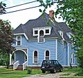
Richard and Mary Woodward Gregory House

This historic house is in Augusta, at 913 E. Augusta Road. It was listed in 2002.
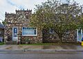
Silas W. Kendall House
The Silas W. Kendall House is located in Oshtemo Township, at 7540 Stadium Drive. It became a historic site in 1990.
David Lilienfeld House
The David Lilienfeld House at 447 W. South Street in Kalamazoo was added to the list in 1986.
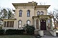
Henry Montague House
The Henry Montague House at 814 Oakland Drive in Kalamazoo was listed in 1983.
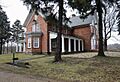
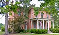
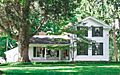
The Oaklands

The Oaklands is a historic property at 1815 W. Michigan Avenue in Kalamazoo. It was recognized in 1983.
Alonzo T. Prentice House
The Alonzo T. Prentice House at 839 W. Lovell Street in Kalamazoo was added in 1983.
Martin W. Roberts House
The Martin W. Roberts House is at 703 Wheaton Avenue in Kalamazoo. It was listed in 1983.
Enoch Shaffer House

The Enoch Shaffer House at 1437 Douglas Avenue in Kalamazoo was added to the list in 1983.
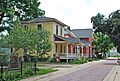
Patrick and Sarah Dobbins Shields House
This house is in Alamo, at 6681 N. 2nd Street. It was recognized as historic in 2007.
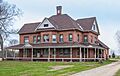
Sparks-Anderson House
The Sparks-Anderson House is located in Oshtemo Township, at 7653 W. Main Street. It was added to the list in 2014.
Andrew J. Stevens House
The Andrew J. Stevens House at 4024 Oakland Drive in Kalamazoo was listed in 1983.
Charles E. Stuart House

The Charles E. Stuart House at 427 Stuart Avenue in Kalamazoo is one of the older listings, added in 1972.
Dr. Nathan M. Thomas House
The Dr. Nathan M. Thomas House is in Schoolcraft, at 613 E. Cass Street. It was listed in 1982.
Important Buildings and Districts
Beyond individual homes, Kalamazoo County has many other types of historic places, from old public buildings to entire neighborhoods.
Booth-Dunham Estate
The Booth-Dunham Estate is a historic district at 6059 S. Ninth Street in Texas Charter Township. It was added to the list in 1998.
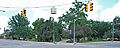
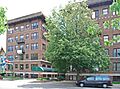
Bronson Park Historic District

Bronson Park Historic District is a significant area in downtown Kalamazoo. It's roughly bounded by S. Rose, S. Park, W. Lovell, and W. Michigan Avenues. This district was listed in 1983.
Climax Post Office Building
The Climax Post Office Building, also known as the Lawrence Memorial Library, is at 107 N. Main Street in Climax. It became a historic site in 1999.
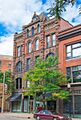
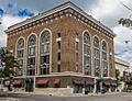
Desenberg Building
The Desenberg Building is an important structure at 251 E. Michigan Avenue in Kalamazoo. It was listed in 1979.
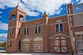
Engine House No. 3

Engine House No. 3 is an old fire station located at 607 Charlotte Avenue in Kalamazoo. It was added to the list in 1983.
Haymarket Historic District
The Haymarket Historic District is another important area in Kalamazoo, along Michigan Avenue. It was listed in 1983, with its boundaries expanded in 2011.
Henderson Park-West Main Hill Historic District

This large historic district in Kalamazoo is roughly bounded by W. Main, Thompson, Academy, Monroe, W. Lovell, and Valley Streets, and Prairie Avenue. It was recognized in 1995.
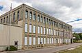
Illinois Envelope Co. Building
The Illinois Envelope Co. Building at 400 Bryant Street in Kalamazoo was listed in 1983.
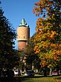
Kalamazoo State Hospital Water Tower

An interesting landmark, the Kalamazoo State Hospital Water Tower on Oakland Drive in Kalamazoo was listed way back in 1972.
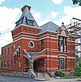
Ladies Library Association Building
The Ladies Library Association Building at 333 S. Park Street in Kalamazoo is a very old listing, added in 1970. It's a beautiful example of historic architecture.
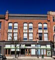
Lawrence and Chapin Building
The Lawrence and Chapin Building at 201 N. Rose Street in Kalamazoo was listed in 1983.
Lee Paper Company Mill Complex

The Lee Paper Company Mill Complex is a large industrial site at 300 W. Highway Street in Vicksburg. It was added to the list in 2016.
The Marlborough
The Marlborough is a building at 471 W. South Street in Kalamazoo, listed in 1983.
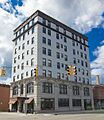
Masonic Temple Building
The Masonic Temple Building at 309 N. Rose Street in Kalamazoo was recognized in 1980.
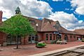
Michigan Central Depot

Also known as the Kalamazoo Transportation Center, the Michigan Central Depot at 459 N. Burdick Street in Kalamazoo was listed in 1975. It's an important part of the city's transportation history.
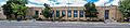
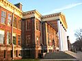
Old Central High School
The Old Central High School at 714 S. Westnedge Avenue in Kalamazoo became a historic site in 1983.
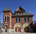
Old Fire House No. 4

Another historic fire station, Old Fire House No. 4, is at 526 N. Burdick Street in Kalamazoo. It was listed in 1983.
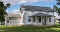
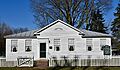
Oshtemo Town Hall
The Oshtemo Town Hall at 10 S. Eighth Street in Oshtemo Charter Township was added to the list in 2004.
Portage Street Fire Station

The Portage Street Fire Station at 1249 Portage Street in Kalamazoo was listed in 1985.
Richland Historic District
The Richland Historic District is a large area in Richland, including several streets. It was recognized in 1997.
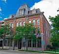
Rickman Hotel
The Rickman Hotel at 345 N. Burdick in Kalamazoo became a historic place in 1994.
Rose Place Historic District
The Rose Place Historic District is a neighborhood along Rose Place in Kalamazoo, listed in 1983.
South Street Historic District

The South Street Historic District in Kalamazoo covers South Street between Oakland Drive and Westnedge Avenue, and other nearby streets. It was first listed in 1979, with boundaries expanded in 1995.
State Hospital Gatehouse
The State Hospital Gatehouse at 1006 Oakland Drive in Kalamazoo was added to the list in 1983.
State Theatre
.jpg)
The State Theatre at 404 S Burdick Street in Kalamazoo is a more recent addition, listed in 2021. Theatres like this are important for showing how entertainment has changed over time.
Stuart Area Historic District
The Stuart Area Historic District is a large historic neighborhood in Kalamazoo, roughly bounded by the Michigan Central railroad line, Douglas, Forbes, W. Main, North, and Elm Streets, and Kalamazoo and Grand Avenues. It was listed in 1983, with boundary increases in 1995.
United States Post Office
The United States Post Office building at 410 W. Michigan Avenue in Kalamazoo was listed in 2017. It's also known as the Kalamazoo Federal Building and U.S. Courthouse.
Vine Area Historic District

The Vine Area Historic District in Kalamazoo is roughly bounded by S. Rose, S. Westnedge, W. Walnut, and Ranney Streets. It was added to the list in 1983.
William L. Welsh Terrace
The William L. Welsh Terrace at 101-105 W. Dutton Street in Kalamazoo was listed in 1983.
Farms and Rural Sites
Some historic places are not just buildings but entire farmsteads, showing us how people lived and worked in rural areas.
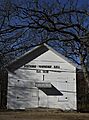
Fanckboner-Nichols Farmstead
The Fanckboner-Nichols Farmstead is located at 5992 West VW Avenue in Prairie Ronde Township. It was added to the list in 2007.
Places That Are No Longer Listed
Sometimes, a historic place might be removed from the National Register. This can happen if the building is destroyed, or if it changes so much that it loses its historic importance.
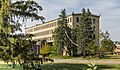
East Hall

East Hall on Oakland Drive in Kalamazoo was listed in 1978 but was removed from the list in 2017.
Western State Normal School Historic District
This district, roughly bounded by Stadium Drive, Oliver Street, and Davis Street in Kalamazoo, was listed in 1990 but delisted in 2017. It was part of the campus of what is now Western Michigan University.
Images for kids
-
The Acres sign
-
Peter B. Appeldorn House
-
Booth-Dunham Estate
-
Bronson Park
-
The Eric and Margaret Brown House
-
Isaac Brown House
-
Old Climax Post Office
-

Delano Homestead
-
The Desenberg Building
-
Drake house
-

Engine House No. 3
-
Fanckboner-Nichols Farmstead
-
John Gibbs House
-
Henry Gilbert House
-
Richard and Mary Woodward Gregory House
-
Haymarket Historic District
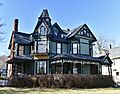
-
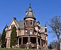
The Henderson Castle
-
Illinois Envelope Co. Building
-
Kalamazoo State Hospital Water Tower
-
Silas W. Kendall House
-
Ladies Library Association Building
-
Lawrence and Chapin Building
-
Lee Paper Company Mill Complex
-
David Lilienfeld House
-
The Marlborough
-
Masonic Temple Building
-
Michigan Central Depot
-
Henry Montague House
-
The Oaklands
-
Old Central High School
-
Old Fire House No. 4
-
Oshtemo Town Hall
-
Portage Street Fire Station
-
Alonzo T. Prentice House
-
Kedzie House in Richland Historic District
-
Rickman Hotel
-
Martin W. Roberts House
-
Rose Place Historic District
-
Enoch Shaffer House
-
Patrick and Sarah Dobbins Shields House
-
South Street Historic District
-
Sparks-Anderson House
-
State Hospital Gatehouse
-

State Theatre
-
Andrew J. Stevens House
-
A building in the Stuart Area Historic District
-

Charles E. Stuart House
-
Dr. Nathan M. Thomas House
-
United States Post Office
-
Vine Area Historic District
-
William L. Welsh Terrace
-
East Hall (former listing)


