
National Register of Historic Places listings in Lake County, Oregon facts for kids
Lake County, Oregon, is a place rich in history, with many important sites listed on the National Register of Historic Places. This list helps protect buildings, places, and objects that are important to American history, architecture, archaeology, engineering, and culture. Think of it as a special hall of fame for historical spots!
Contents
Ancient Art and Early Life
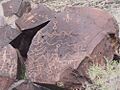
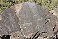
Abert Lake Petroglyphs
Imagine people living thousands of years ago, drawing pictures on rocks! That's what you'll find at the Abert Lake Petroglyphs. These amazing rock carvings, called petroglyphs, were made by early people from the Great Basin cultural tradition. They carved these pictures onto two large basalt rocks.
These carvings are near old routes where animals used to migrate. Experts believe they were part of hunting rituals. While we know they were made sometime in the last 10,000 years, their exact age is a bit of a mystery. They show us how ancient people lived and thought.
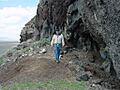
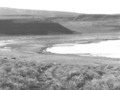
East Lake Abert Archeological District
This area is like a giant outdoor museum, full of clues about how people lived long, long ago. It's an important place for archeologists to study the past.
Fort Rock Cave

Fort Rock Cave is a super important historical site. Archeologists found something incredible here: the "Fort Rock sandals." These sandals are the oldest manufactured items ever found in the Americas! They show us that early Native Americans were skilled at weaving a very long time ago.
People lived in this cave around 11,000 years before the Common Era (BCE). That's a really, really long time ago! It helps us understand how early humans lived and developed skills.
Greaser Petroglyph Site
Just like the Abert Lake site, the Greaser Petroglyph Site has more ancient rock carvings. These drawings give us more clues about the beliefs and daily lives of the early people who lived in this area.
Paisley Five Mile Point Caves
These caves are another amazing place where scientists learn about ancient life. They hold secrets about the very first people who lived in this part of Oregon.
Picture Rock Pass Petroglyphs Site
This site is home to even more incredible petroglyphs. These rock art pieces are like ancient messages, telling stories from thousands of years ago. They are a valuable link to the past.
Historic Buildings and Ranches
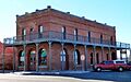
Bailey and Massingill General Store

The Bailey and Massingill General Store was Lakeview's very first commercial building. It opened way back in 1876. Sadly, the original store was destroyed in a big fire in 1900.
But the owners didn't give up! They rebuilt the store right away. The new building had special features to prevent fires, like walls covered in metal and a fire awning. This shows how important it was to protect businesses back then.
Ed Eskelin Ranch Complex
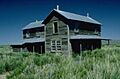
The Ed Eskelin Ranch Complex was built in the 1930s. What's cool about it is that it used both new materials and salvaged parts from old buildings. This ranch shows how tough and determined small farmers were.
They faced challenges like dryland farming not working out around 1910. But then, in the 1930s, they found success with irrigated farming. This ranch tells a story of perseverance and adapting to the land.
Heryford Brothers Building

The Heryford Brothers Building is an important part of Lakeview's downtown history. It's a well-preserved example of the kind of buildings that were central to town life in the past.
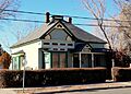
William P. Heryford House

This beautiful house was once the home of William P. Heryford. It's a great example of the homes built in Lakeview during its early development.
Lake County Round Sale Barn

The Lake County Round Sale Barn is a unique building. Its round shape makes it stand out and shows a different style of construction for a barn. It was used for selling livestock.
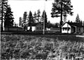
Nevada–California–Oregon Railway Passenger Station
_(lakDA0025).jpg)
This old train station was once a busy hub for travelers. It was part of the Nevada–California–Oregon Railway, connecting Lakeview to other areas. Train stations like this were vital for travel and trade in the past.
Post and King Saloon

The Post and King Saloon is another historic building in Lakeview. Saloons were important gathering places in old Western towns, serving as social centers.
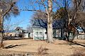
David L. Shirk Ranch
.jpg)
The David L. Shirk Ranch is a large historic ranch in Guano Valley. Ranches like this played a huge role in the development of Lake County, focusing on raising livestock.
John N. and Cornelia Watson House

This house belonged to John N. and Cornelia Watson. It's another example of the historic homes that make up the rich history of Lakeview.
Unique Historical Sites
Mitchell Recreation Area

The Mitchell Recreation Area holds a very special and sad place in American history. It is the only place in the continental United States where Americans were killed during World War II due to enemy action. This site serves as a memorial to that event.
Stone Bridge and the Oregon Central Military Wagon Road

The Stone Bridge is an old bridge that was part of the Oregon Central Military Wagon Road. This road was important for travel and moving goods across the region a long time ago. Bridges like this were crucial for connecting different areas.
Images for kids
-
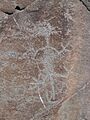
An example of a petroglyph from Abert Lake.
-
A historic administrative building in Oregon from 1935.
-
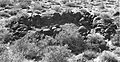
A view of the East Lake Abert Archeological District.
-
A building at the Eskelin Ranch Complex.
-
Petroglyphs found at the Greaser Petroglyph Site.
-
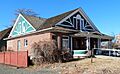
Another view of the William P. Heryford House.
-
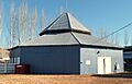
The interior of the Lake County Round Sale Barn.
-
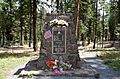
The Mitchell Monument, a memorial to a unique WWII event.
-
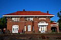
The old train station in Lakeview.
-
Inside one of the Paisley Five Mile Point Caves.
-
More ancient rock art from Picture Rock Pass.
-
The Post and King Saloon.
-
The main house at the David L. Shirk Ranch.
-
The historic Stone Bridge.
-
The John N. and Cornelia Watson House.


