
National Register of Historic Places listings in Macoupin County, Illinois facts for kids

Have you ever wondered about old buildings and places that tell a story? In Macoupin County, Illinois, there are some really special spots that are listed on the National Register of Historic Places. This is like a special list of important buildings, areas, and objects in the United States that are worth protecting because of their history.
These places help us learn about the past. They show us how people lived, worked, and built things many years ago. Macoupin County has 8 of these amazing historic places. Let's explore some of them!
Exploring Macoupin County's Historic Treasures
Macoupin County is home to several unique places that have earned a spot on the National Register of Historic Places. Each one has its own story to tell about the area's past.
John C. Anderson House
The John C. Anderson House is a beautiful old home located in Carlinville, Illinois. It's found at 920 West Breckenridge Street. This house is a great example of the architecture and style from when it was built. It helps us imagine what life was like for families living in Carlinville long ago.
Carlinville Chapter House
Also in Carlinville, at 111 South Charles Street, is the Carlinville Chapter House. This building has been an important meeting place for a local group. It shows how communities came together and organized themselves in the past. It's a reminder of the social life and groups that shaped the town.
Carlinville Historic District
The Carlinville Historic District is not just one building, but a whole area of Carlinville that is special! It's roughly bounded by Oak, Mulberry, Morgan streets, and the eastern city limits. This district includes many historic buildings, like the impressive Macoupin County Courthouse. Walking through this area is like stepping back in time, with many old buildings showing off different styles of architecture. It helps us see how the town grew and changed over the years.
J. L. Robinson General Store
Out in Hagaman, Illinois, you can find the J. L. Robinson General Store. It's located off Illinois Route 108. This old store was once a central spot for people in the area to buy everything they needed. Imagine a time before big supermarkets, when a general store was the heart of a small community. It's a cool example of how people shopped and connected in the past.
Route 66, Girard to Nilwood
Part of the famous U.S. Route 66 between Girard and Nilwood is also a historic listing. This section of the road, between Illinois Route 4 south of Girard and Illinois Route 4 near Nilwood, is a piece of American history. Route 66 was a major highway that connected the country and became a symbol of travel and adventure. This part of the road reminds us of the journeys people took and the growth of car travel.
Shriver Farmstead
The Shriver Farmstead is an old farm located northwest of Virden, Illinois. Farmsteads like this one are important because they show us how farming was done in the past. They include old farmhouses, barns, and other buildings that were essential for daily life and work on a farm. This site helps us understand the agricultural history of Macoupin County.
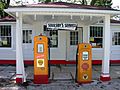
Soulsby Service Station
Another cool spot on Route 66 is the Soulsby Service Station in Mount Olive, Illinois. You can find it at 102 South Route 66 Street. This old gas station is a classic example of roadside architecture from the early days of car travel. It served travelers on the historic Route 66, offering gas and a place to rest. It's a fun reminder of road trips from long ago.
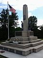
Union Miners Cemetery
The Union Miners Cemetery is a very important historical site located about half a mile north of the Mount Olive city park in Mount Olive, Illinois. This cemetery is special because it's where many coal miners and labor leaders are buried. It's a place that honors the struggles and sacrifices of workers who fought for better conditions. It reminds us of the important history of mining in Illinois and the fight for workers' rights.
Images for kids
-
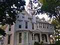
The John C. Anderson House in Carlinville.
-
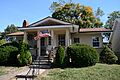
The Carlinville Chapter House.
-

The Macoupin County Courthouse, part of the Carlinville Historic District.
-
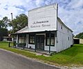
The J. L. Robinson General Store in Hagaman.
-
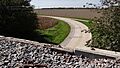
A section of historic Route 66 between Girard and Nilwood.
-
The Soulsby Service Station in Mount Olive.
-
The monument at Union Miners Cemetery.


