
National Register of Historic Places listings in Mitchell County, Kansas facts for kids

Have you ever wondered about old buildings or places that are super important to history? In the United States, there's a special list called the National Register of Historic Places. It helps protect and celebrate places that tell us about the past. This list includes buildings, bridges, and even whole neighborhoods that are important for their history, design, or what happened there.
This article shares a list of all the places in Mitchell County, Kansas, that are on this important National Register. There are 13 special spots in the county that have been added to the list.
Contents
Historic Places in Mitchell County
Mitchell County is home to several fascinating places listed on the National Register of Historic Places. These sites help us understand the history and development of the area.
Bridges with History
Some of the oldest and most interesting structures on the list are bridges. These bridges were built a long time ago using strong masonry (stone or brick) and are still standing today.
- Antelope Creek Masonry Arch Bridge: This bridge is near Tipton. It was added to the list in 2014.
- Brown's Creek Tributary Masonry Arch Bridge: You can find this bridge near Glen Elder. It also joined the list in 2014.
- North Rock Creek Masonry Arch Bridge: Located near Hunter, this bridge was also recognized in 2014.
Important Homes and Farms
Many homes and farms in Mitchell County have a rich history.
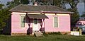
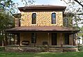
- Cather Farm: This farm near Beloit was added to the Register in 2007. It's an important example of early farm life in the region.
- Abram Click Farmstead: Also near Beloit, this farmstead joined the list in 2013. It shows how farms were set up and used long ago.
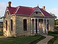
- F. H. Hart House: This historic house in Beloit was recognized in 1973. It's a great example of the architecture from its time.
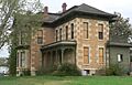
- C. A. Perdue House: Another significant home in Beloit, this house was added to the Register in 1976.
Community Buildings and Landmarks
Public buildings and businesses also play a big role in a community's history.
- E. W. Norris Service Station: Located in Glen Elder, this old service station was listed in 1976. It reminds us of how cars and travel used to be.
- Mitchell County Courthouse: The main courthouse for Mitchell County, located in Beloit, became a historic site in 1977. Courthouses are often central to a town's history and government.
- Old Cawker City Library: This former library in Cawker City was added to the list in 1973. Libraries are important places for learning and community gathering.
- Porter Hotel: In Beloit, the Porter Hotel was recognized in 2004. Hotels like this were once busy hubs for travelers and local events.
- St. John the Baptist Catholic Church: This beautiful church in Beloit was listed in 1975. Churches often have deep roots in a community's social and spiritual life.
Historic Neighborhoods
Sometimes, a whole area or street is important enough to be listed.
- Wisconsin Street Historic District: This entire block in Cawker City was added to the Register in 1986. It's a collection of buildings that together show a significant part of the town's past.
Images for kids
-
The historic Cather Farm house.
-
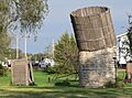
An outhouse and water tower at the Abram Click Farmstead.
-
The E. W. Norris Service Station in Glen Elder.
-
The F. H. Hart House in Beloit.
-
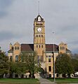
The Mitchell County Courthouse.
-
The Old Cawker City Library.
-
The C. A. Perdue House.
-
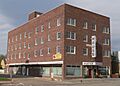
The Porter Hotel.
-
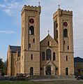
St. John the Baptist Catholic Church.
-
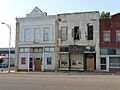
Buildings along Wisconsin Street in Cawker City.
_house_from_WNW_1.JPG)


_from_SSW_1.JPG)


_from_SW_1.JPG)
_from_SSW_2.JPG)

