
National Register of Historic Places listings in Monroe County, Illinois facts for kids

Welcome to Monroe County, Illinois! This page is all about special places here that are listed on the National Register of Historic Places. Think of this register as a super important list of buildings, areas, and sites across the United States that are worth protecting because of their history or unique design.
These places are like treasures from the past. They help us learn about how people lived a long time ago and what was important to them. In Monroe County, there are 7 amazing places on this list right now. One other place was on the list but isn't anymore. We'll tell you about the ones that are still considered important historic spots!
Contents
What is the National Register of Historic Places?
The National Register of Historic Places is the official list of places in the United States that are important for their history, architecture, archaeology, engineering, or culture. It's like a special honor roll for buildings, sites, and objects that tell a story about our country's past. When a place is added to this list, it means it's recognized as a valuable part of history that should be preserved for future generations.
Historic Places in Monroe County
Monroe County has several cool spots that have earned a place on this important list. Let's explore some of them!
Fountain Creek Bridge

The Fountain Creek Bridge is an old bridge located near Waterloo. It was added to the National Register in 1978. This bridge is a great example of older engineering and how people used to build structures to cross rivers and creeks. It's a reminder of how transportation has changed over the years.
French Colonial Historic District

The French Colonial Historic District is a large area that stretches from Fort Chartres State Park all the way to Kaskaskia Island. It's near Prairie du Rocher and was added to the list in 1974. This district is super important because it shows us what life was like when French settlers first came to this part of Illinois. You can find old buildings and sites that tell stories of early American history, even extending into Randolph County.
Gundlach-Grosse House

The Gundlach-Grosse House is a historic home located at 625 North Main Street in Columbia. It joined the National Register in 1978. This house is a beautiful example of the architecture from its time. It gives us a peek into the lives of families who lived in Columbia many years ago.
Lunsford-Pulcher Archeological Site

The Lunsford-Pulcher Archeological Site is a very special place for history detectives! It's located on the western side of Oklahoma Hill Road, near Columbia. This site was added to the list in 1973. It's an archaeological site, which means it's a place where scientists study old human activity by digging up artifacts. This site has helped us learn a lot about ancient cultures that lived in this area, even extending into St. Clair County.
Maeystown Historic District

The Maeystown Historic District is a charming area in the town of Maeystown. It was recognized as historic in 1978. Maeystown is known for keeping its old-world German charm. Walking through this district feels like stepping back in time, with many well-preserved buildings that show the town's unique heritage.
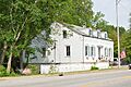
Peterstown House

The Peterstown House is another important building in Waterloo, found at 275 North Main Street. It was added to the National Register in 1977. This house has a rich history and is a great example of the kind of homes built in the area a long time ago. It's a landmark that tells stories of the past residents of Waterloo.
Waterloo Historic District

The Waterloo Historic District covers most of the central part of Waterloo. It was added to the list in 1978. This district includes many historic buildings and areas that show the growth and development of Waterloo over the years. It's a great place to explore and see how the town has changed while still keeping its historic feel. The beautiful Monroe County Courthouse is one of the important buildings in this district.
Images for kids
-
Location of Monroe County in Illinois
-
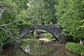
Fountain Creek Bridge
-
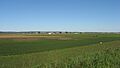
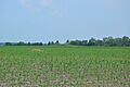
American Bottom in far southern Monroe County
-
Gundlach-Grosse House
-
Lunsford-Pulcher Site from Oklahoma Hill Road
-
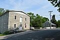
Mill at Franklin, Maeystown
-
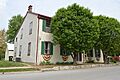
Peterstown House
-

Monroe County Courthouse, Waterloo
