
National Register of Historic Places listings in Montgomery County, Arkansas facts for kids

Have you ever wondered about the old buildings and special places in your town or county? In Montgomery County, Arkansas, there are many historic spots that are so important, they've been added to a special list called the National Register of Historic Places. This list helps protect and celebrate places that tell us about the past.
This article will tell you about the 14 amazing places and areas in Montgomery County that are on this list. It's like a treasure map of history! One place used to be on the list but was later removed. Let's explore these cool historical sites together.
What is the National Register of Historic Places?
The National Register of Historic Places is the official list of the United States' historic places worth saving. It's like a hall of fame for buildings, structures, objects, sites, and districts that are important to American history, architecture, archaeology, engineering, or culture. When a place is added to this list, it means it's recognized as a special part of our country's heritage.
It's managed by the National Park Service. Being on the list can help protect these places and sometimes even provide money for their care. It encourages people to appreciate and preserve these historical treasures for future generations, like you!
Historic Places in Montgomery County
Montgomery County is home to several fascinating places on the National Register. These sites include old schools, unique shelters built in forests, and even a historic courthouse. Each one has a story to tell about the people and events that shaped this part of Arkansas.
Let's take a closer look at some of these special locations:
Caddo Valley Academy Complex
The Caddo Valley Academy Complex is located in Norman. It was added to the National Register in 2002. This complex likely includes buildings that were part of an old school or academy, which played an important role in educating young people in the area long ago.

CCC Company 741 Powder Magazine Historic District
Northeast of Norman, you'll find the CCC Company 741 Powder Magazine Historic District. This site was listed in 2007. It's connected to the Civilian Conservation Corps (CCC), a program during the Great Depression that helped young men find work building parks and other public projects. A "powder magazine" was a safe place to store explosives used for construction.
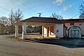
Collier Springs Shelter
The Collier Springs Shelter is located northeast of Norman, within the beautiful Ouachita National Forest. It was added to the list in 1993. This shelter was likely built for people to use while enjoying the forest, perhaps by the CCC. It's a great example of how people used to connect with nature.

Crystal Springs Camp Shelter and Dam
Also in the Ouachita National Forest, near Norman, are the Crystal Springs Camp Shelter and the Crystal Springs Dam. Both were listed in 1993. The camp shelter was a place for people to stay, but sadly, it was damaged by a falling tree in 2016. The dam helped control water and create a scenic area.

Historic Dipping Vats
You might find it interesting that two "dipping vats" are on the list: the Cogburn Dipping Vat near Black Springs and the Guinn Dipping Vat near Mauldin. Both were listed in 2006. Dipping vats were used in the past to treat livestock, like cattle, to protect them from ticks and diseases. They are a reminder of how farming and animal care used to be done.
Huddleston Store and McKinzie Store
In Pine Ridge, you can find the Huddleston Store and McKinzie Store, listed in 1984. These old stores were once important centers for the community, where people bought supplies, shared news, and socialized. They show us what life was like before big supermarkets.

Montgomery County Courthouse
The Montgomery County Courthouse in Mount Ida was listed in 1976. Courthouses are very important buildings in any county. They are where local government decisions are made, and where many official records are kept. This courthouse is a symbol of justice and community in Montgomery County.

Mount Ida Cities Service Filling Station
Also in Mount Ida is the Mount Ida Cities Service Filling Station, listed in 2001. This old gas station reminds us of the early days of cars and road trips. It shows how transportation has changed over time and how important these service stations were for travelers.

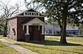
Norman Town Square
The Norman Town Square in Norman, listed in 1993, is another important historic district. Town squares are often the heart of a community, where people gather, events happen, and businesses are located. This square tells the story of how the town of Norman grew and developed.

Reeves-Melson House
Near Bonnerdale, you'll find the Reeves-Melson House, listed in 1985. Historic homes like this one give us a peek into the daily lives of families from the past. They often have unique architectural styles and stories about the people who lived there.

Womble District Administration House No. 1
East of Mount Ida is the Womble District Administration House No. 1, listed in 1993. This building likely served as an administrative center for a district, perhaps related to forest management or other public services. It shows how different parts of the county were organized and managed in the past.

Former Listings
Sometimes, a place might be removed from the National Register. This can happen if the building is destroyed, or if it changes so much that it no longer has its historic importance.
Mount Ida Esso Service Station
The Mount Ida Esso Service Station was once on the list, added in 2001, but it was removed in 2012. It was located on U.S. Route 270 in Mount Ida. Even though it's no longer on the list, it was still a part of the county's history for a time.
Images for kids
-
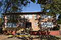
The Caddo Valley Academy Complex
-
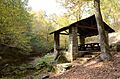
The Collier Springs Shelter
-
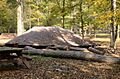
The Crystal Springs Camp Shelter
-
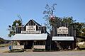
The Huddleston Store and McKinzie Store
-

The Montgomery County Courthouse
-
The Mount Ida Cities Service Filling Station
-
The Norman Town Square
-

The Reeves-Melson House
-

The Womble District Administration House No. 1
