
Norman, Arkansas facts for kids
Quick facts for kids
Norman, Arkansas
|
|
|---|---|

Norman Public Library on the town square
|
|

Location in Montgomery County, Arkansas
|
|
| Country | United States |
| State | Arkansas |
| County | Montgomery |
| Area | |
| • Total | 1.14 sq mi (2.95 km2) |
| • Land | 1.13 sq mi (2.91 km2) |
| • Water | 0.01 sq mi (0.04 km2) |
| Elevation | 722 ft (220 m) |
| Population
(2020)
|
|
| • Total | 303 |
| • Density | 269.33/sq mi (104.02/km2) |
| Time zone | UTC-6 (Central (CST)) |
| • Summer (DST) | UTC-5 (CDT) |
| ZIP code |
71960
|
| Area code(s) | 870 |
| FIPS code | 05-50030 |
| GNIS feature ID | 2406998 |
Norman is a small town located in Montgomery County, Arkansas, United States. It was once known by a different name, Womble, until 1925. In 2020, about 303 people lived in Norman. This number was a bit lower than the 378 people who lived there in 2010.
Contents
Geography of Norman
Norman is found in the southern part of Montgomery County. It sits where two main roads, Highway 8 and Highway 27, meet.
The town is about 9 miles (14 km) south of Mount Ida. Mount Ida is the main town, or county seat, of Montgomery County. Norman is also about 13 miles (21 km) northwest of Glenwood.
Natural Surroundings
Norman is right next to the Caddo River. The river forms the town's southwestern edge. The town is also surrounded by the large Ouachita National Forest. This means there are lots of trees and nature nearby.
The United States Census Bureau says Norman covers about 1.14 square miles (2.95 square kilometers). Only a tiny part of this area, about 0.014 square miles (0.04 square kilometers), is water.
Local Names and History
The western part of Norman is sometimes called Middlebuster. In the past, it was even known as "Poor Horse."
There is a special place on the southern edge of town. It is a burial ground for the Caddo Native American people. City officials, led by former mayor Duane Cox, found and protected this important site with a wooden fence. More recently, Caddo descendants have added a path, benches, and signs. These signs share historical facts about how the Native Americans lived long ago.
People of Norman
The number of people living in Norman has changed over the years. Here's how the population has looked:
| Historical population | |||
|---|---|---|---|
| Census | Pop. | %± | |
| 1910 | 552 | — | |
| 1920 | 420 | −23.9% | |
| 1930 | 478 | 13.8% | |
| 1940 | 512 | 7.1% | |
| 1950 | 401 | −21.7% | |
| 1960 | 482 | 20.2% | |
| 1970 | 505 | 4.8% | |
| 1980 | 539 | 6.7% | |
| 1990 | 382 | −29.1% | |
| 2000 | 423 | 10.7% | |
| 2010 | 378 | −10.6% | |
| 2020 | 303 | −19.8% | |
| U.S. Decennial Census | |||
In 2000, there were 423 people living in Norman. These people lived in 190 homes, and 117 of these were families. The town had about 365 people per square mile (141 people per square kilometer).
Community Makeup
About 25% of the homes had children under 18 living there. Many homes, about 41%, were married couples. About 17% of homes had a female head of household without a husband.
The population was spread out by age. About 26% were under 18 years old. About 19% were 65 years or older. The average age in Norman was 40 years old.
Education in Norman
Students in Norman attend public schools. The Caddo Hills School District provides education for elementary and high school students. Young people in Norman usually graduate from Caddo Hills High School.
In 1971, the Norman School District joined with the Caddo Gap school district.
Fun Places to Visit
If you visit Norman, you might want to see these places:
- Crystal Springs Dam
- Crystal Springs Camp Shelter
Getting Around Norman
The main roads that help people travel to and from Norman are:
- Arkansas Highway 8
- Arkansas Highway 27
Gallery
-
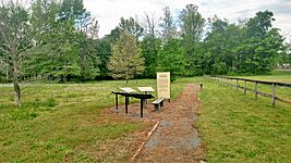
Caddo burial mound
-
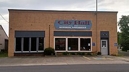
Town hall
-
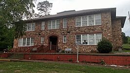
Former school


See also
 In Spanish: Norman (Arkansas) para niños
