Mount Ida, Arkansas facts for kids
Quick facts for kids
Mount Ida, Arkansas
|
|
|---|---|

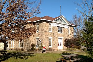
Montgomery County Courthouse in downtown Mount Ida
|
|
| Motto(s):
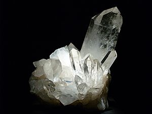
"Quartz Crystal Capital of the World"
|
|

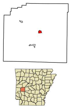
Location in Montgomery County, Arkansas
|
|
| Country | United States |
| State | Arkansas |
| County | Montgomery |
| Incorporated (city) | May 30, 1890 |
| Area | |
| • Total | 1.60 sq mi (4.14 km2) |
| • Land | 1.57 sq mi (4.06 km2) |
| • Water | 0.03 sq mi (0.08 km2) |
| Elevation | 659 ft (201 m) |
| Population
(2020)
|
|
| • Total | 996 |
| • Density | 634.80/sq mi (245.06/km2) |
| Time zone | UTC-6 (Central (CST)) |
| • Summer (DST) | UTC-5 (CDT) |
| ZIP code |
71957
|
| Area code(s) | 870 |
| FIPS code | 05-47690 |
| GNIS feature ID | 2404320 |
Mount Ida is a city in Arkansas, United States. It is the main town and county capital of Montgomery County. The city was started in 1842. In the 1880s, a "silver boom" brought a lot of growth and money to the area.
Today, the city's economy relies on several things. These include ranching (raising animals), poultry farming (raising chickens), and silviculture (growing trees for wood). Tourism around Lake Ouachita is also very important. Mount Ida is famous as the "quartz crystal capital of the U.S." It is known worldwide for its amazing quartz deposits. In 2020, about 996 people lived in Mount Ida.
Contents
History of Mount Ida
Mount Ida officially became a city on May 30, 1890. This was an important step in its development.
Geography of Mount Ida
Mount Ida is located in the middle of Montgomery County. It sits on the south bank of the South Fork of the Ouachita River. Two main roads, US Route 270 and Arkansas Highway 27, go through the town.
US 270 goes east about 36 miles to Hot Springs. It also goes northwest about 86 miles to Heavener, Oklahoma. AR 27 goes northeast about 46 miles to Danville. It also goes southwest about 9 miles to Norman. The actual mountain named Mount Ida is about 5 miles southwest of the town, along Route 27.
The city of Mount Ida covers about 1.60 square miles. A small part of this area, about 0.03 square miles, is water.
Mount Ida's Climate
The weather in Mount Ida has hot, humid summers. Winters are usually mild to cool. According to the Köppen Climate Classification system, Mount Ida has a humid subtropical climate. This means it gets a lot of rain and has warm temperatures for most of the year.
| Climate data for Mount Ida, Arkansas (1991–2020 normals, extremes 1883–present) | |||||||||||||
|---|---|---|---|---|---|---|---|---|---|---|---|---|---|
| Month | Jan | Feb | Mar | Apr | May | Jun | Jul | Aug | Sep | Oct | Nov | Dec | Year |
| Record high °F (°C) | 87 (31) |
86 (30) |
91 (33) |
93 (34) |
97 (36) |
108 (42) |
110 (43) |
116 (47) |
107 (42) |
100 (38) |
89 (32) |
83 (28) |
116 (47) |
| Mean daily maximum °F (°C) | 53.0 (11.7) |
56.9 (13.8) |
65.4 (18.6) |
73.6 (23.1) |
80.5 (26.9) |
88.4 (31.3) |
92.9 (33.8) |
92.7 (33.7) |
86.3 (30.2) |
75.3 (24.1) |
63.5 (17.5) |
55.0 (12.8) |
73.6 (23.1) |
| Daily mean °F (°C) | 41.8 (5.4) |
45.5 (7.5) |
53.3 (11.8) |
61.5 (16.4) |
69.4 (20.8) |
77.2 (25.1) |
81.0 (27.2) |
80.4 (26.9) |
73.4 (23.0) |
62.2 (16.8) |
51.5 (10.8) |
43.6 (6.4) |
61.7 (16.5) |
| Mean daily minimum °F (°C) | 30.7 (−0.7) |
34.0 (1.1) |
41.2 (5.1) |
49.3 (9.6) |
58.3 (14.6) |
66.1 (18.9) |
69.2 (20.7) |
68.2 (20.1) |
60.5 (15.8) |
49.1 (9.5) |
39.6 (4.2) |
32.2 (0.1) |
49.9 (9.9) |
| Record low °F (°C) | −15 (−26) |
−21 (−29) |
4 (−16) |
20 (−7) |
30 (−1) |
41 (5) |
47 (8) |
43 (6) |
31 (−1) |
20 (−7) |
6 (−14) |
−6 (−21) |
−21 (−29) |
| Average precipitation inches (mm) | 3.81 (97) |
4.04 (103) |
5.01 (127) |
6.17 (157) |
5.44 (138) |
4.77 (121) |
4.20 (107) |
3.66 (93) |
4.14 (105) |
4.44 (113) |
5.25 (133) |
4.82 (122) |
55.75 (1,416) |
| Average precipitation days (≥ 0.01 in) | 8.6 | 9.9 | 10.9 | 9.9 | 12.0 | 9.8 | 10.2 | 8.3 | 7.6 | 9.3 | 9.1 | 9.4 | 115.0 |
| Source: NOAA | |||||||||||||
Population of Mount Ida
| Historical population | |||
|---|---|---|---|
| Census | Pop. | %± | |
| 1920 | 298 | — | |
| 1930 | 512 | 71.8% | |
| 1940 | 490 | −4.3% | |
| 1950 | 566 | 15.5% | |
| 1960 | 564 | −0.4% | |
| 1970 | 819 | 45.2% | |
| 1980 | 1,023 | 24.9% | |
| 1990 | 775 | −24.2% | |
| 2000 | 981 | 26.6% | |
| 2010 | 1,076 | 9.7% | |
| 2020 | 996 | −7.4% | |
| U.S. Decennial Census | |||
2020 Census Information
In 2020, the census counted 996 people living in Mount Ida. There were 428 households, which are groups of people living together. Also, there were 273 families living in the city.
Parks and Outdoor Fun
The Ouachita National Forest is a huge forest area. It is located in Montgomery County, very close to Mount Ida. This forest is the oldest and largest national forest in the southern United States. It has beautiful places like Little Missouri Falls. You can also find many trails for hiking and backpacking there. Lake Ouachita is one of the biggest lakes in the area. Part of this large lake is also found within Montgomery County.
Famous People from Mount Ida
Mount Ida has been the birthplace of a few notable people:
- Mark Davis: A professional sport fisherman. He is known for competing in the Bass Anglers Sportsman Society.
- Lon Warneke: A former Major League Baseball player. He also worked as a Major League umpire after his playing career.
- Charles L. Watkins: The first Parliamentarian of the United States Senate. He was born and grew up in Mount Ida.
See also
 In Spanish: Mount Ida (Arkansas) para niños
 | Janet Taylor Pickett |
 | Synthia Saint James |
 | Howardena Pindell |
 | Faith Ringgold |


